Stacks of energy outta the south

Sydney, Hunter and Illawarra Surf Forecast by Ben Matson (issued Friday 21st June)
Best Days: Mon: abating winds and a fun though lumpy SE swell. Tues: strong, long period S'ly groundswell with lighter winds. Easing throughout Wed.
Recap: Thursday delivered strong lines of S’ly swell anywhere from 4-6ft at south facing beaches, with clean conditions under a generally light variable breeze. Wave heights eased back today to 3-4ft at south facing beaches, with early offshore winds swinging moderate southerly before lunch.
This weekend (June 22 - 23)
Today’s Forecaster Notes are brought to you by Rip Curl
Looks like a couple of windy days ahead, thanks to a strong ridge of high pressure over the eastern states, maintaining a fresh southerly airstream throughout much of the NSW coast.
We’ll see a mix of southerly swells both days, from a couple of sources: the low responsible for yesterday’s lovely groundswell lines re-intensified in the central/southern Tasman Sea yesterday and is generating some moderate-period energy that will fill in tomorrow.
Additionally, the local fetch adjacent the coast will kick up short to mid range energy that’ll blend in between the inconsistent longer period swell.
South facing beaches will pick up the most size, but conditions will be very ordinary; sets should push 4ft to maybe 6ft at times on Saturday, easing from 4-5ft to 3-4ft Sunday, but both days will have quality issues at exposed beaches. There’s a chance for isolated pockets of early SW winds but I fear this will be limited to just one or two coasts at best.
Away from south facing beaches, you’ll pick up much smaller but cleaner surf. Keep your expectations low and you'll do OK.
Next week (June 24 onwards)
The low responsible for both yesterday’s Sly swell and tomorrow’s underlying energy will meander through the southern Tasman Sea over the weekend, in a pretty decent swell generating capacity.
I think the models are undercalling early next week’s size; we’re looking at SE swells holding between 3ft and occasionally 5ft on Monday, easing from Tuesday onwards as the low weakens and contracts to the northern Tasman Sea.
We’ll continue to see persistent S’ly through SE winds on Monday but the pressure gradient will ease so conditions will slowly start to improve. There’s a better chance for a brief morning sou’wester but expect some wobble through the lineup at exposed spots.
Elsewhere, we’ve got some other interesting features to monitor over the weekend.
Over the next few days, a series of large, intense polar lows will skirt the iceshelf below the Tasman Sea (see chart below). They’ll be mainly aimed at points north-east from New Zealand, but the sheer size and strength of the accompanying fetches will generate a spread of long period S’ly swell that’s due to push through Southern NSW overnight Monday, reaching Sydney beaches through Tuesday and then easing from Wednesday. The Far South Coast could pick up the leading edge of this swell very late Monday if we’re lucky.
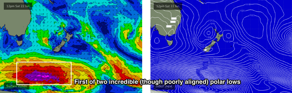
At this stage we’re looking at inconsistent but strong 4-5ft sets at most south facing beaches at the height of the event (Tuesday) with some offshore bombies and reliable south swell magnets (i.e. the Hunter) likely to push north of 6ft+ thanks to the ipressive swell periods (leading edge could be 19-20 seconds).
A second pulse is expected to trail closely behind the first pusle (originating from a powerful secondary polar low) but I have feeling both swells will probably blend into one sustained event from late Monday thru' Tuesday and perhaps early Wednesday. Expect much smaller surf at beaches with less southerly expxosure. And it'll be inconsistent too.
Local conditions look better on Tuesday (than Monday) but still not amazing, with light to moderate winds tending variable but probably S/SE for a period. Light variable winds will then play out for the second half of the week as this southerly swell progression eases back in size.
There’s nothing of any great interest in the long term, outlook at this stage, but I’ll have more on that in Monday’s update.
Have a great weekend!
Comments
Glad the southerly change was behind schedule today didnt switch til 130 got a good hour of clean surf and not that crowded for a change. Double thumbs up.
Hey Ben. Question re land & water temperature differential - water is hovering around 20, early mornings are 9-10c and the maps have a obvious SE flow for which the model is calling a 10knot onshore. Due you have any rules of thumb for wind differences between forecasted winds and actual?
Whoops! Sorry, missed this. No state-wide rules of thumb as it's site specific. But the weaker the synoptic flow, the better your chances for terrestrial influences.
Good day for Hang-gliding in Newy today

At least someone’s enjoying it...