Wide range of swells on the way

Sydney, Hunter and Illawarra Surf Forecast by Ben Matson (issued Monday 24th June)
Best Days: Tues/Wed: fun mix of S'ly and SE swells with improving conditions. Sun: fun E/NE swell with offshore winds. Next week is on target for an extended, solid E/NE tending E'ly swell.
Recap: Strong southerly swells were present over the weekend, and conditions were a little better than expected with most locations seeing morning offshore winds from the W/SW thru’ SW; the Northern Beaches held from this direction for much of Saturday too. However many coasts still fell under the influence of a broader synoptic southerly flow and this pattern has persisted into today. Wave heights reached 4-6ft early Saturday, easing to 3-5ft early Sunday and we’ve see a slight reinforcement of S/SE swell today with 3-4ft sets at south facing beaches. The leading edge of a new long period S’ly swell expected this evening is yet to show across the region’s buoy network.
Next week (June 25 - 28)
Today’s Forecaster Notes are brought to you by Rip Curl
We’ve got two swell sources for the next few days.
The current S/SE swell will ease in size but tend more SE into Tuesday, originating from the weakening remnants of the Tasman Low that generated the most recent S’ly swells. Most open beaches should see 2-3ft sets, with smaller surf at protected southern ends.
There will however be a stronger S’ly groundswell in the water. The polar low responsible for this upcoming long period event displayed some amazing wind strengths over the weekend. Though, we have to be mindful when assessing ASCAT data because the map projection distorts the width of the fetch (making it look bigger than it is).
Still, because there were a passage of intense lows one after the other, generating a sustained, active sea state, I’m confident that we’ll see some impressive long period energy arriving this evening - providing solid waves at south facing beaches. It'll be very inconsistent at times but anywhere in the 3-5ft range at south facing beaches, with occasional sets pushing 6ft or more at reliable south swell magnets (such as the Hunter) and offshore bombies. Expect much smaller surf at beaches not open to the south.
Local winds are expected to throttle back into Tuesday, though without a synoptic offshore there’s still likely to be some wobble at exposed spots. And bear in mind the significant inconsistency of this swell - there’ll be very long breaks between waves.
Wave heights will then trend down through Wednesday, though still occasional 3-4ft at south facing beaches early, a shade bigger at swell magnets but much smaller at beaches not open to the south. We may see isolated regions of light to moderate onshore winds at times but in general it’ll be variable under 10kts with minimal affect on surf quality.
Surf size will become small through Thursday and Friday though it won’t go completely flat, as a slowly developing ridge through the central/northern Tasman Sea will kick upon small east swell for exposed beaches. I doubt we’ll see much more than a weak 1-2ft but this will keep exposed beaches active. However with mainly light winds there’ll be favourable conditions for a quick beach break session.
This weekend (June 29 - 30)
We’ve got a significant E/NE swell on the cards for next week, and the weekend should see an increase from the early stages of the same broad scale parent system, though surf size will be much smaller.
At this stage we’re looking at increasing size into the 2-3ft+ range across open beaches (posisbly a lag Saturday morning), with early NW winds on Saturday freshening from the north throughout the day as an unrelated cut-off low pressure system passes across Tasmania. This will then swing the wind to the west on Sunday.
As such, we’re on track for clean offshore winds for Sunday with plenty of fun peaky E/NE swell. Well worth booking this into the diary.
Next week (July 1 onwards)
The E/NE swell for next week will be generated by a slow moving tropical low expected to develop near New Caledonia later this week, and strengthen into the weekend (see chart below).
The length and strength of the associated fetch looks very impressive in the current model runs, but what I like even more is its stationary position, which should push surf size above model guidance (4-5ft), with occasional 5-6ft+ sets likely at exposed beaches through Monday afternoon and Tuesday.
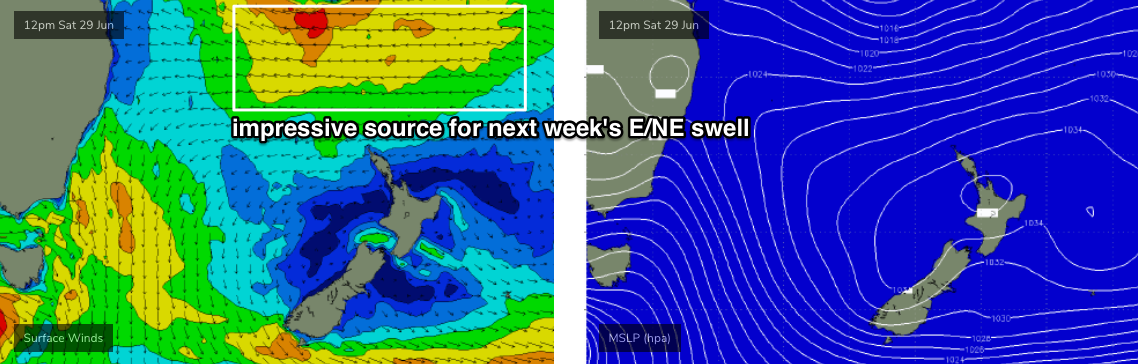
In fact, it looks like a regional blocking pattern will allow this low to push into the Tasman Sea into next week, bringing the E’ly fetch more into our direct swell window, swinging the swell direction more to the east, then south-east as the week progresses. This could maintain elevated E'ly swells for quite some time across our region.
Additionally, we’ll see small underlying long period S’ly swells next week from a series of intense though poorly aligned polar lows moving under Tasmania later this week and into the weekend.
So.. it’s shaping up to be quite an active time frame ahead. More in Wednesday’s notes.
Comments
At last some lovely East swell
Nice for a change
Sunday sounds good. So many options. Consider it booked. Hashtag Crosses fingers double thumbs up.
Solid S'ly groundswell set at Queensy..
Surfing mid-late morning at North Steyne the south groundswell noticeably increased in size and power with strong 3ft to nearly 4ft sets. Curly would be solid.