Put the diary aside for next week, will ya?

Sydney, Hunter and Illawarra Surf Forecast by Ben Matson (issued Wednesday 26th June)
Best Days: Sun: fun E/NE swell with offshore winds. Mon/Tues: large E/NE swell with offshore winds. Wed-Sun: plenty of E/NE swell; tricky winds Wed though and maybe an additional S'ly swell.
Recap: Another long period S’ly swell pushed up the coast on Tuesday, offering 4-5ft sets at south facing beaches and occasional 6ft+ bombs at a handful of south swell magnets. Conditions were lumpy clean early with light winds but southerly winds redeveloped during the day. Wave heights eased from 3-4ft to 2-3ft today with mainly light variable winds swinging onshore throughout the day.
This week (June 27 - 28)
Today’s Forecaster Notes are brought to you by Rip Curl
There’s no major surf expected for the next few days. However, it won’t go flat either.
The current S’ly swells will continue to ease into Thursday, and we’ll see some residual E’ly energy from a modest ridge developing through the northern Tasman Sea. It’s not particularly strong in our direct swell window but we should still pick up peaky 1-2ft waves both days, with a chance for a few slightly bigger sets very late Friday.
Local winds should be generally light and variable both days, with just a late northerly tendency cropping up south of Sydney on Friday afternoon. So, expect reasonable conditions but nothing spectacular.
This weekend (June 29 - 30)
There's no change to the weekend outlook at this stage.
Saturday should start off clean, but winds will freshen from the north as a front approaches from the west, so we’ll see bumpy conditions develop throughout the day, maybe even some small N/NE windswell showing late afternoon and overnight.
A W’ly change is expected in the early hours of Sunday morning, so this will brush the ocean clean.
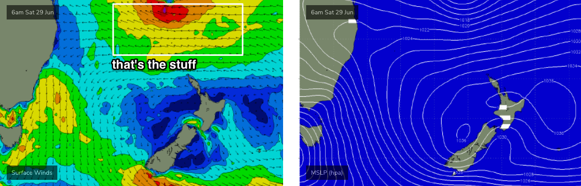
As for surf, aside from the small NE windswell mentioned above (which may hold into early Sunday but ease rapidly through the day), the primary swell source is a broadening, strengthening easterly fetch in the northern Tasman Sea later this week in conjunction with a significant low pressure system developing between New Caledonia and Fiji.
Whilst we’re not expecting a peak from this event until Monday and Tuesday, the early stages of this synoptic cycle will kick up a fun mid-range E/NE swell through Saturday into Sunday with peaky 2-3ft+ sets across the region (expect smaller surf early Saturday ahead of the increase). Our model has an easing trend through Sunday afternoon but I think this is incorrect, and we should see some great waves all day.
The leading edge of the main swell is expected to reach our coast on Sunday night. There’s a chance this could be brought forward by Friday’s update, but even if that happens it’ll probably only allow for an hour or two of (rapidly increasing) new swell before sunset at best (thanks to last light being much earlier this time of the year). Had this situation been positioned in late December, then the chances of a late session from the new swell would be higher.
Anyway, I’ll reassess the timing in Friday’s notes. But for now, the real juice will be in the water for Monday morning.
Next week (July 1 onwards)
There’s a lot to get excited about with this tropical low - it’ll be broad, very strong, slow moving, and aimed in a really nice part of our swell window for quite a while. Large E/NE groundswell events are not as common as we’d like to see, and in my humble view it’s actually one of the better directions for Southern NSW. This swell should light up most locations with quality, sizeable surf.
At this stage I’m still pushing above model guidance (4-5ft) and expecting solid 5-6ft+ surf at exposed locations, peaking later Monday and probably early Tuesday before easing slowly into the afternoon and Wednesday. Light variable winds are expected both days, trending W’ly if anything, so there’ll be quality options everywhere.
The models have shifted the long term position of this system a little since Monday’s outlook, but it’s still going to remain a very good spot: slightly further east, and stationary, probably until the middle of the week at least. This should fluctuate wave heights between 3ft and 5ft range from Wednesday through Saturday morning, easing a little into the weekend but likely to remain somewhere in the inconsistent 2-3ft range.
The only other swell source is a short-lived, poorly aligned (though very powerful) low south of Tasmania on Sunday - linked in with the W’ly wind change across Southern NSW - that may deliver some small S’ly swell on Monday and Tuesday. It’ll be hard to spot beneath the E/NE groundswell though.
Wednesday is at risk for a developing SW tending S/SW airstream as a front pushes into the Tasman Sea and forms a low towards New Zealand; we may also pick up a short range S’ly swell from this pattern (late Wed/Thurs) but let’s take a closer look on Friday.
Comments
Wow so the swell will essentially start this weekend and continue right through until the end of next weekend.
And E/NE swell as well.
Offshoreys.
Bonus!
Now that's some cranking good news right there!
Geez... I hope this forecast stays true..it will be game on !! FROATHING
Nothing like post trip backlog to postpone customers again