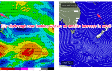
We’ll see several different sources of swell from this system, most of which will overlap at some point so it’ll be hard to distinguish them all (and kinda pointless really, seeing how rapidly surf size will increase). But let’s take a look at a few of ‘em.
Primary tabs
/reports/forecaster-notes/sydney-hunter-illawarra/2025/05/26/coupla-large-south-swells-ahead-plenty
thermalben
Monday, 26 May 2025
/reports/forecaster-notes/sydney-hunter-illawarra/2025/05/22/improving-conditions-plenty-swell-nor
freeride76
Friday, 23 May 2025
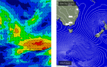
We’ll see plenty of swell from this low-carb nor-easter, with a slow easing trend over the weekend, more pronounced on Sun.
/reports/forecaster-notes/sydney-hunter-illawarra/2025/05/21/mid-strength-black-noreaster-the-boil
thermalben
Wednesday, 21 May 2025
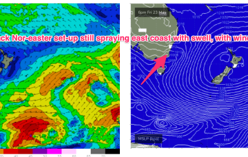
This synoptic set up is akin to a mid-strength black nor’easter, with an impressive fetch stretching all the way from Far Southern NSW to Fiji and Tonga.
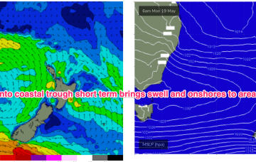
/reports/forecaster-notes/sydney-hunter-illawarra/2025/05/19/wild-and-wooly-weather-ahead-still
freeride76
Monday, 19 May 2025
A very unstable, dynamic synoptic chart this week with a large high (1034hPa) moving from the Bight through Victoria, with a coastal trough deepening off the Mid North Coast on the leading edge of the high directing very moist onshore winds across Central NSW, extending up into the sub-tropics.
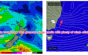
/reports/forecaster-notes/sydney-hunter-illawarra/2025/05/15/tasman-sea-gets-rowdy-next-week
freeride76
Friday, 16 May 2025
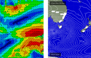
We’ve got good model agreement now that through Mon we’ll see a deep trough develop from the Coral Sea down to a terminus somewhere on the MNC to lower North Coast with good odds we will see a surface low develop at that terminus.
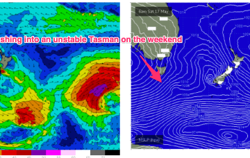
/reports/forecaster-notes/sydney-hunter-illawarra/2025/05/14/fun-beachies-continue-short-term-the
freeride76
Wednesday, 14 May 2025
Next week still looks dynamic with potential for a deep trough or low in the Tasman, although we are going to have to play it day by day due to poor model to model and run to run consistency.
/reports/forecaster-notes/sydney-hunter-illawarra/2025/05/12/clean-beachies-until-mid-week-dynamic
freeride76
Monday, 12 May 2025
The recent pattern of very strong highs moving through the Bight into the Tasman then resets over the weekend with a high likelihood of another surge of S-SE swell during this period

/reports/forecaster-notes/sydney-hunter-illawarra/2025/05/09/fun-waves-and-dynamic-synoptics-abound
thermalben
Friday, 9 May 2025
There’s actually a couple of E/NE swell sources for early next week. And a S'ly swell too!
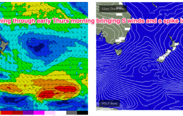
/reports/forecaster-notes/sydney-hunter-illawarra/2025/05/07/spike-in-s-swell-short-term-another
freeride76
Wednesday, 7 May 2025
In between, a trough and cold front are currently approaching Tasmania, expected to bring a vigorous S’ly change o/night, bringing a spike in short range S swell short term.
/reports/forecaster-notes/sydney-hunter-illawarra/2025/05/05/spell-small-clean-surf-the-next-large
freeride76
Monday, 5 May 2025
We’ll see the current dominant high (1034hPa) over New Zealand which is directing a broad trade fetch through the South Pacific and into the Coral Sea slowly migrate eastwards this week with an E’ly dip form a trough of low pressure due E of SEQLD mid week.