Know Your Product: Why The Tides?

Given a few years surfing, most surfers develop an intuition for tidal movements. We understand how high and low tides effect the waves, how long it is between tidal shifts, and how they all link to lunar phases. This knowledge helps us get good waves, but when it comes to explaining what tides are, how they form, and how they propagate around the world, it's a vastly incomplete body of knowledge.
Getting right back to basics, tides are bulges of water that circle the globe caused by the gravitational pull of the moon, and to a lesser extent the sun. The sun is the greater body – it's diameter is 400 times that of the Moon's - but because of its distance from Earth its effect is greatly diminished. Hence, the moon is the main driver of our tides.
If Earth were totally covered with water it'd be relatively easy to track and map the movement of the tides. Two bulges of water would follow the moon, one on the side facing the moon, the other on the exact opposite side due to centrifugal force. The bulges would rotate with rhythmic consistency and the changes in tide level would clearly mesh with the moon phase – from full moon to new moon and back again.
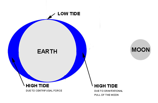
In simplest terms, the tides are bulges of water that follow the moon
The tidal range - calculated in vertical metres - changes with the monthly lunar phase. The range is greatest during the full moon and new moon because the Sun, Moon, and Earth are all in a line and hence working together. The tidal range is lowest when the Sun is at 90° to the Earth and Moon (when half the Moon is visible)
Imagining the Earth as a watery planet is more than a mental exercise, it shows that for all their complexities the basis for tides is really quite simple - amphidromic points notwithstanding, but we'll come to that later.
Tides begin to get complicated when those bulges of water begin to interact with coastlines, the underlying bathymetry, and with water from other ocean basins. It's then that water starts behaving unusually and tides can no longer be explained in simple terms.
Hawaii is one place where tides are easy to understand and predict. The simple explanation is that the Hawaiian Islands are small, have no continental shelf, and are located far away from any land mass, meaning there is very little interference with the passing tidal bulges. The tidal difference in Hawaii is surprisingly small, just a few feet separate the highest and lowest tides of the year and average daily differences are in the order of two feet.
At the other extreme are coastlines that have long continental shelfs which both slow the tides and and exaggerate the tidal difference. In Australia's north-west lies the resource rich North West Shelf which extends hundreds of kilometres out into the Timor Sea. The North West Shelf augments the tidal flow so by the time it reaches the coast it's far greater than it would otherwise be. Tides of several vertical metres are not uncommon in north-west Australia, same as other places with lengthy continental shelfs such as England, France, and parts of the US east coast.
Continental shelfs aren't the only geographic feature that can increase tides. Bays, estuaries, rivers, and sounds can do the same. The common link of the aforementioned features is that they're semi-confined bodies of water; linked to the ocean and thus tide dependent, but small enough to create their own tidal environment.
Just as an inclining shelf amplifies the tide, so to does a narrow body of water, particularly a funnel-shaped bay or sound. The top spots for tidal difference in the world are the Bay of Fundy in eastern Canada and Derby in north-west WA. Both have large continental shelfs and large bays – Derby is located at the southern end of King Sound – and both have tidal differences that peak over ten vertical metres.
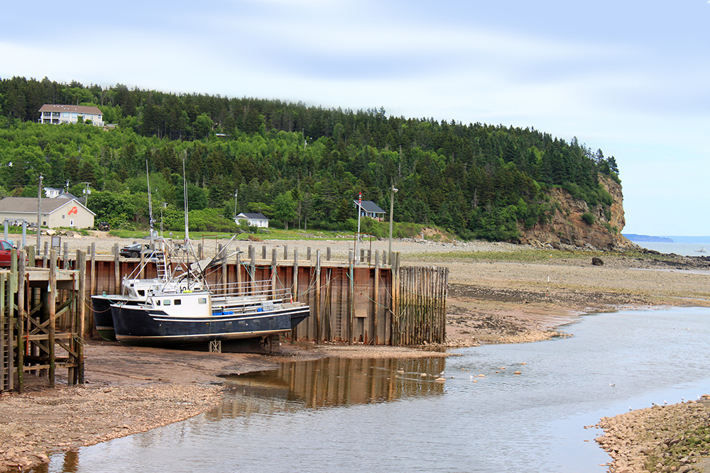
Fishing boats dry docked by the outgoing tide in the Bay of Fundy
Between the barely-there tides in Hawaii and the three storey tides in Derby lies a wide range of differences, and they're all due – or at least mostly due – to nearby geographic features. Water acts weird when it's interfered with...and that brings us to the timing of the tides.
Most locations around the world have two highs and two lows in a day – what's known as semi-diurnal tides – though some coastlines, generally in regions with large tidal differences, have just one tide – called a diurnal tide. Things get complicated when regions of semi-diurnal and diurnal tides meet. When that happens you can forget trying to predict the tides day by day as they rarely follow a calculable path and instead are dictated by a seemingly random methodology. Western Australia's South-west is one place with a mix of diurnal and semi-diurnal tides.
It's not random of course, rather there are multiple drivers influencing the timing of the tides so the pattern they follow is harder to ascertain.
And speaking of difficult patterns: when it comes to understanding tides, the elephant in the room is the amphidromic system, and this is where things get really weird.
To understand the amphidromic system we have to revisit that image of the watery planet with tidal bulges circling it. Imagine that those rotating bulges are actually waves with massively elongated wavelengths inexorably moving around the planet. When the continents are accounted for and the unseen bathymetry below, all of which diverts and influences the rotating waves of water, the result is scattered points on the ocean where there is almost no vertical movement. They're called amphidromic points and they're best described by the mathematical field of wave harmonics: amphidromic points are created by the cancelling out – or the interference – of opposing waves.
Even better, when viewed on a global scale the tides no longer move east to west, they actually rotate around amphidromic points. Check the next image and the following video to make sense of it.
First the image, which shows amphidromic points around the globe - see the converging lines in areas of blue - and arrows showing the direction the tides rotate around them.
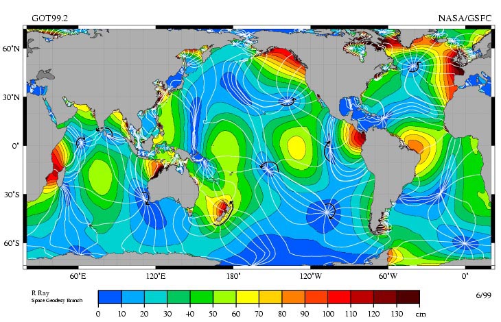
(With Permission R. Ray, TOPEX/Poseidon)
Now the video. The colour yellow denotes zero height and note how the amphidromic points stay yellow the whole time. Choose an easy one such as the point offshore from south-west WA. As surrounding waters turn blue (low tide) and orange (high tide) it stays yellow. If our imaginary watery planet model were real everywhere would experience high and low tides, yet it isn't the case.
Earlier I gave you the simple explanation for Hawaii's meagre tidal range: no continental shelf, no land mass. The other reason is that it lies fairly close to an amphidromic point in a region that sees little vertical movement.
Another amphidromic point worth looking at is New Zealand. The whole country is considered an amphidromic point as the tidal bulge rotates around the North and South Island (see video) in a counter-clockwise direction. Unlike, say, Australia's East Coast where places on the same longitude share similar tide times, neighbouring regions in NZ can have greatly differing tides. Best you keep a tide chart handy.
On Australia's East Coast we're a little spoilt for tides. The range is great enough to service an array of waves yet not so great that conditions change radically. We have permanent semi-diurnal tides, and, as mentioned above, most of the coast experiences similar tide phases making it easier to keep track of tides while on a road trip.
Before we make for the exit it's worth noting that the tidal predictions you read in the newspaper/website/fishing chart are just that - predictions. Aside from the influence of the Sun and Moon, plus the coastal geography and the bathymetry, tides are also effected by the Coriolis Force, the tilt of the Earth's equator, the inclination of the lunar orbit, and the elliptical shape of the Earth's orbit of the sun. Then there are the real time factors such as barometric pressure which can lower or rise the sea surface, and local winds that can 'pile up' water against a coast, both of which can alter tidal readings.
It's a chaotic system with many different agents influencing the outcome, and it's a marvel that scientists have managed to maintain the accuracy they have.
Past articles:
Know Your Product: Real Buoys vs Virtual Buoys
Know Your Product: Wave Period
Comments
Fascinating... And I imagine that was a very basic summary that barely scratched the surface.
You got it. When I began this article I figured it'd be a breeze, but it quickly became clear you can follow the study of tides as far as you wanna go and it extends way beyond what general readers could comprehend (or care about).
There's some amazing reading out there for those so inclined.
If anyone could explain the central west WA tides to me I'm all ears.
tbh I never bothered about tides in formative years over in WA, just surfed. Only developed understanding of them in travels over east. NW Coast of Tassie was the most stark differences I've seen.
Cute story but it's an absolute crock. Believe whatever you want but Bill O'Reilly explained the facts much clearer than you.
Tide goes in, tide goes out, never a miscommunication:
?t=110thank you! so good
well done stu! i love this stuff but I agree with Benski - if you're implying that there is no invisible man in the sky with this convoluted explanation i'm going back to the church surf forecasting website thing
Good read, but I'm puzzled by how the centrifugal force in the left of the first diagram relates to the pull of the moon.
Are you referring to the centrifugal force from the earth's rotation that causes the equatorial bulge? That is responsible for differences in sea levels, but would be a separate force to the gravitational pull of the moon, especially as the moon's orbit is not aligned with the equator.
The diagram seems to conflate the two.
Or is there another force at work that I'm not aware of?
Not counting bearded sky-men....
"Good read, but I'm puzzled by how the centrifugal force in the left of the first diagram relates to the pull of the moon."
Well yeah, it is puzzling and I came across a few different explanations for the bulge on the opposite side of the moon. None were definitive so I went on the most common explanation, that the bulge was the balancing effect of centrifugal force.
Another explanation was that the bulge was gravitational, that gravity takes a path of least resistance and so flows through the earth causing another, lesser, bulge on the opposite side. See following pic:
It's possible that it's a combination of the two; gravity causes the bulge on the Moon-ward side and the other bulge is caused by an equal and opposite force.
Apologies for being unclear. Like I said, I couldn't find a definitive explanation for it.
The Moon doesn't actually rotate around the centre of the Earth. The Earth and Moon both rotate around the centre of gravity of the Earth-Moon system. This point is known as the 'barycentre' (which is very close to the centre of the Earth in this case).
Think of the two bodies as a binary system.
This rotation around a common centre of gravity is what induces the outward centrifugal force. The centrifugal force is equal to the gravitational force (the inward centripetal force in this system), this balances the system. The result of this balance is that we get a back bulge on the other side of the Earth causing a secondary tide equal in strength to the primary gravitational tide, and, that the Moon doesn't collide with the Earth due to the gravitational pull.
Nice one Tfo. You dropped my penny. So to speak.
It was a light bulb moment for me too when I learnt this. Something that's really obvious in hindsight.
That was a much better explanation than my oceanography professor gave at Sydney Uni.
His explanation when I asked was basically "when you add up all the vector sums of the centripetal and gravitational forces this is what you get". Thanks Tfo
Great article Stu. I was over in the U.K three weeks ago and was staying down at St. Ives, Cornwall which is on the South West tip of England.
It was during the last full moon and the tides were massive! The harbour would go from completely dry to almost flooding the town over a couple of hours. If a huge storm and swell coincided with a full moon tide there I wonder what happens to St Ives?
Here's two pictures taken on the same day.
Great shots YS. How's the top one? Get to the bottom of the boat ramp and the water is still waaaay over there.
That's cool YS. It's possible to walk out of the (dry) boat harbour at Newquay in Cornwall to surf the town beaches on a big day: you get a little white water just after the harbour entrance.
Great article Stu, thanks. A non-surfing Canadian mate who I shared it with wasn't happy about you handing the Bay of Fundy over to the US though.
Yorkesurfer - I've been in that part of the world. Some of the beaches around there are really wide (at low tide) and flat too so you can watch the tides come rolling in literally by the second. Beautiful coast.
Heh heh...whoops. Those Canucks are sensitive of misappropriation at any time but with all the election craziness going down they really want to distance themselves from their southern neighbour.
Error fixed.
Croyde is really interesting as it has deeply scalloped sand bar formations, you walk a long way out on low tide, right over these and know you'll be surfing over them in a little while. Agree, cracker of a coast.
A bit more here : Swellnet - Nick Bone -Tides
Eh?
A thread you started on tides
Couldn't agree more Swellnet! Eastcoast spoilt for tides we are. Top read!
How best to surf these tides ?
Body language of tide-turning! Ever expanding.....
(Hands on guide for fellow swellnetonians.)
Following applies to Surfing natural RIGHT HAND waves...in either hemisphere .
Many know how to race a high line or stall a tail into a hard 'n' heavy pit.
Lets advance those options utilising full tidal effect.
(Use Incoming tide to):
Accelerate up-face vorticing counter- clockwise down with lip for barrel-roll rushing with incoming tide to fly faster out from out your barrels in a spiral manner.
(Use Outgoing tide to):
Stall 'n' reverse up-face corkscrewing clockwise back up with lip for barrel-roll using outgoing tide to re- enter your barrels.
(Top of the tide-turning) Eye-up outward backwash for your aerial counter-clockwise round the world or over the top comb-over maybe back slam a christmas beetle.
(Back of the tide-turning)Cocoon drop several wave-faces pod deep in the funnel spiralling clockwise to harness more outgoing wave power the deeper and lower you go.
(Reverse osmosis for goofy/LEFT HAND breaks). Hooroo! Happy to share.
.
[BEACHSIGN]
Says- Riding the tides in/out/roundabout/upside down/back to front is dangerous.
.
That video is great! Its a real shame that sw WA doesn't get more tidal variation.
Hey all,
I was under the impression that the tidal high on the opposite side of the earth to the moon was due to the difference in gravitational field strength with distance from the mass of the moon. I.e. The water on the moon side is being pulled towards the moon more than the earth and the earth is being pulled towards the moon more than the water on the far side of the moon... proportional to the inverse square of the distance from the mass of the moon... it also makes sense to me that it could be due to centripetal forces and/or the fairly well established oscillation of the tides.
Sheesh... this whole time i've thought it was pretty much just rotational bulgy movements - now that amphidromic points are in my life i'm gonna sound a whole lot better in the parking lot. ha... thanks for the great article..
Haha, love to hear that dropped in the car park!
Isnt the inverse barometer effect a big feature also?
Much smaller feature, less predictable.
East coast surfcraft riders and SUPS from 1820's onward mastered local tidal patterns.
When The Big Fresh flooded the The Big Scrub...upon king-tide. It became time for shootin' the rapids. No rules applied !
Next building then anchoring your surfcraft required know-how,so not to have it crushed by tides.
Next surfing the Ebb Tide out thru the Tweed River mouth was a unique skill.
Top of the tide surfing back in thru the point lineup by riding incoming tides.Then banking coastline north off littoral current backed by southerly swell.
(note) Any misreading of the tides here... would see surfers cast out to sea and drifting helplessly south or wiped-out on rocky point breaks.(Todays... Gold Coast surfing reserves)
Flood tides were ridden back in to enable surfing thru South Passage(Nerang Heads... Seaway).
(note) Any misreading of the tides here... would see surfers swept north to Moreton Island or wiped-out on the smashed craft littered heads.
Inside the estuary- tides transported all from as far as Nerang to Ipswich for over a century.
(note) Any cross river ebb current could easily take your surfcraft back out through river mouth.(No Jumpinpin Bar meant water moved faster then)
Tidal Punting once a way of life along all eastcoast rivers.( SUP Couriers are not new! )
Awesome stuff, Stu n Swellnet. As I commented before, I hope you are syndicating these articles into the inflight magazines of the various airlines that fly into surf destinations. Hell, they could go into any of them ;)
Be such a shame to invest the time into researching and writing to only have it published once.
Or, are you going to put all these "know your product" articles into a coffee table book, released just prior to a key retail event (i.e. fathers day or Christmas)?
Fuck, I've gotta say it ... MORE OF THESE and less reproduced ABC articles!
Venice > (3 Extreme record Tides in 15 months) + 2 Aussie Tide Anomalies
Nov 2019 > [ + 1.87cm ]
https://www.abc.net.au/news/2019-11-18/venice-suffers-record-flood-for-t...
Jan 2020 > [ - 45cm ] below sea level
https://www.abc.net.au/news/2020-01-14/venices-canals-dry-due-to-low-tid...
March 2020 - Dolphins & Swans in Crystal Clear Venice Canals (Nope!)
Feb 2021 >[ - 48cm ] below sea level
https://www.independent.co.uk/news/world/europe/venice-canals-low-tide-v...
................................................................................................................................
Recent Oz E/W coasts Tidal Anomalies (Not Major Storm surges!)
WA (Perth) Canning River Weir Saltwater breaches...
Nov 2009 - Oct 2010 > 3 breaches
Sept 2010 - May 2011 (La Nina) > 66 breaches (Note: Not a lot higher just constant!)
Weir was refurbished 2017 (n/a)
Tweed River ( 2 Significantly Higher than predicted East Cost tides)
Bray Park Weir (1983) Above Murwillumbah- Salt Water breaches
Weir has had some "minor" salt incursions but 2 larger recent episodes.
21/22nd Aug 2017 - Oz Tweed River Weir was well & truly topped
25/26th May 2020 - (320mm above predicted tide / 15ML flow-in before Toppers).
Shows recent record tides repeatedly rise/fall for 2 years approx' at specific sites.
How do these far reaching locales relate....need more research into more sites!
2020 NT / North Qld had a lot of Mega Whales up small creeks.(Not normal)
Anyhow...it gives crew a window into rough mechanics of wild tide anomalies.
Kinda hints that if a site has one tidal anomaly it either returns or over compensates.
That sure seems like natures way...it's not always gonna run by our tide charts.
Certainly would be a revelation if we could link more 1-3 year anomalies.
Science would say our sample is pure coincidence at this stage & they'd be right.
Antartica 2020/21
https://www.nbcnews.com/science/environment/two-giant-icebergs-broke-ant...
https://www.nationalgeographic.com/environment/article/world-largest-ice...
This just happened
All good Stu, very good article. I’ve been thinking about it for about 30 years, but still haven’t fully understood why some parts get only two tides a day as opposed to our four. Gulf of Carpentaria is a good one to think about because so much water has to move around to get into the Gulf, a fkn large body of water, but don’t fully comprehend why it is still the case in NW WA.
Re the bulge at the back, yeah, better explained above by proper sciency person, but it’s just gravity, although that says nothing because it’s all gravity really, isn’t it.
Funny, I was going to write a long piece on how being a surfer brings you into tune with the natural world, weather, tides, barometric pressure, winds. All the essential things. For those who haven’t considered it, for a certain indigenous group that has been here somewhere around 40 to 60K years, yeah, they passed down some observed knowledge. Freaking goldmine in indigenous knowledge, if only we weren’t so stupid not to look.
Know a thing or two about our local climate too.
And I’m sure many on here watch where the full moon rises, and see how vastly different it can be. Goes from south of east to quite north of north east, and the wobble is significant.
Also loved it when I learned that the tides they tell us are just predictions, and as TBB offers, can vary substantially.
It’s a freaking wonderful world.
NT Tide strands 600 Intoxicated teens on shrinking sandbank in Croc Territory.
Oh the Humanity...Tinnie Carnage...[Vote Now] Oz most fucked up Piss Head Gromz
or Bestest Covid Freedom Party Ever...."Please can we be Quarantined now!"
Luv Darwin...Farkin' Classic!
https://www.9news.com.au/national/coronavirus-updates-nt-darwin-party-sa...
https://www.abc.net.au/news/2021-09-13/sandbar-party-darwin-lives-at-ris...
Neap tides?
Why the difference between the two low tides on these same day? E.g today’s lows at Port Phillip Heads 0.19 and 0.54
Probably the same reason why the two high tides in a day are not the same. Isn't it because the bulge the moon side is a bit bigger than the bulge on the non-moon side, so the same forces pushing water in are pulling water away just at different rates depending if it's on the moon side or not. Just my guess.
Great tide guide
animation explanation of spinning earth & ocean motions
https://moon.nasa.gov/resources/444/tides/
West coast of Tassie has two tides a day. Outgoing during the day, incoming at night. Please explain.
Not entirely sure about that, Doc. West Coast Tas can have long periods - weeks and sometimes months - when the tides appear fixed in a certain phase, such as high tide through the early hours of the morning. However, roll forwards or backwards a few months and the phases appear to change. Lows through the early mornings, for example.
Note: I'm making this assessment off tide tables while sitting 2,000kms away from Tassie, so if you're on the ground and seeing something different then, as long as you're rigorous, trust your own observations first.
What I do know is west coast Tas has a mix of diurnal and semi-diurnal - so a mix of one full tide phase and two full phases - and that makes it very hard to discern any sort of pattern. As I wrote above:
"Things get complicated when regions of semi-diurnal and diurnal tides meet. When that happens you can forget trying to predict the tides day by day as they rarely follow a calculable path and instead are dictated by a seemingly random methodology."
Wish I understood it better.
Great explanation. Thanks, Stu.
It's hell when you think that the surf's going to be good on high, and the tide just goes out all day!
Great article Stu, intriguing and informative as usual. Can you explain the low tide predictions for me as we never hit a low of 0.00M. For example Sydney just had its lowest low tide of the year I believe at 0.18M and in all my years I have never seen a 0.00m low.
Cheers
Squidy
The average Sydney sea level is rising; as measured at Fort Denison for the last 100 years
https://psmsl.org/data/obtaining/stations/65.php
https://psmsl.org/data/obtaining/rlr.annual.plots/65_high.png
..... it was in some of the papers, radio & TV; refuted as greenwash by Murdock & oily mates
Very interesting Intel there bbb. Why would that only include up to 1990?
Permanent Service for Mean Sea Level (PSMSL) is the global data bank for long term sea level change information from tide gauges and bottom pressure recorders.
The PSMSL is based at and supported by the UK's National Oceangraphy Centre, but have no ongoing external source of funding.
Reference: https://psmsl.org/
Worldwide Trends: https://psmsl.org/products/trends/
Interesting variations in sea level around the world: https://psmsl.org/train_and_info/geo_signals/
Tide data has to be sent by Govt staff, then uploaded & calculated in a database, GIS & websites maintained.
Many Govt Depts have reduced overheads by reducing experienced, qualified staff on their payroll.
(eg. CSIRO; Aust Museum, Fisheries, Dept Ag, Soil Con, Landcare, etc)
PR is however booming in this climate of efficiency & colouring in the knowledge vacuum.
" if either the crust subsides or the sea surface uplifts, the tide gauge will measure a sea level rise. Therefore, these two effects cannot be separated with tide gauge data alone. Using GPS receivers near tide gauges to measure land motion provides additional information "
A can of worms with cans of worms inside. Chuck a giant undersea volcano in and good luck measuring anything.
I just thought this was all set in stone. Mind blown
Great question Squidy..
The 0.0 point, known as the tidal datum is Mean Lower Low Water mark.
It's calculated not just from a yearly cycle but an entire epoch and takes the average of all the lower of the two low water heights seen through the day (ie average of the lowest daily tide). Hence you can get slightly negative tides.
If historical data is used to calculate an average but that data is lagging behind real time progressive change then they can't really be very accurate can they?
There must be charts of actual tide heights like bbb shared above. With all the variables interacting, how do they compare?
I learned a lot from this article thanks and greatly appreciate your efforts to make sense of it all
Not historic, they update the tidal forecasts all the time, based on the tidal constituents changing regarding the planets, moon and sun's gravitational pulls.
Also there are observations of tidal height at certain locations around the country, and then the difference to this forecast owing to pressure influences, storm-surges etc.
https://www.swellnet.com/news/swellnet-analysis/2016/04/19/inverse-barom...
Yes of course that's much more scientific if they update the data regularly.
So over time are they continually predicting higher high tides but the predictions are being regularly exceeded by real time data ???
I'm amazed to realise how seemingly 'analogue' this all is. Big number crunching is based on assumptions
.
Gravity is relative to size & motion; part of Einstein's theory in 1905
https://cdn.jwplayer.com/previews/0OSUcXLt
this may confuse or elaborate
Great read.
Can anyone explain: when I see predictions of a 0.2 metre low and a 1.6 metre high.
I am assuming there is a 0.0 point and the above measurements are done in reference to that said 0.0. How is this zero calculated/ estimated? What does it represent? If it is a low point, how are there tidal predictions which are negative numbers?
Thanks
The 0.0 point, known as the tidal datum is Mean Lower Low Water mark.
It's calculated not just from a yearly cycle but an entire epoch and takes the average of all the lower of the two low water heights seen through the day (ie average of the lowest daily tide). Hence you can get slightly negative tides.
Thanks Craig.
Nicely explained. Like your surfing - precise and simple.
I’m learning a lot from Swellnet about so much around the ocean and weather.
Next question - Is thunder the sound of clouds bumping into each other?
Ha, thanks!
Nah the sound is made from the rapid expansion of the air from heating by lightning, then rapid contraction as the air cools again following the lightning. This warps the air creating the sound.
Was serious about your surfing and not about the clouds but still know more than I did before re thunder.
Thanks
Cheers!
Is this rapid warping/expansion of air creating a sonic boom?
Yep!
Maybe you called the top 10 articles too soon?
Can't see the can for the worms on this one (no apologies for mixing)
My old local (fair way up the Bristol Channel, UK) has roughly 6 different surf spots on the same day
There are a lot of variables, with the sun & planetary movements being the most predictable
Bureau of Meteorology monthly maximum and minimum tides for Sydney
http://www.bom.gov.au/ntc/IDO70000/IDO70000_60370_SLD.shtml
UK tides
https://ntslf.org/tides/hilo
Barometric pressure tides eg Macquarie Harbour in western Tassie.
Greatest incoming tide :) in ancestral memory:
https://www.giss.nasa.gov/research/briefs/2007_gornitz_09/
"Climate warming is expected to result in rising sea level. Should this occur, coastal cities, ports, and wetlands would be threatened with more frequent flooding, increased beach erosion, and saltwater encroachment into coastal streams and aquifers. Global sea level has fluctuated widely in the recent geologic past. It stood 4-6 meters above the present during the last interglacial period, 125,000 years ago, but was 120 m lower at the peak of the last ice age, around 20,000 years ago. A study of past sea level fluctuations provides a longer-term geologic context, which can help us better anticipate future trends.
Massive ice sheets covered parts of North America, northern Europe, and several other regions during the last ice age. This huge volume of ice lowered global sea level by around 120 meters as compared to today. "
"After the ice sheets began to melt and retreat, sea level rose rapidly, with several periods of even faster spurts. The first such spurt may have started about 19,000 years ago, at which time ocean levels rose 10-15 m in less than 500 years. However, this event is not seen in all past sea level records and new evidence suggests that ice melting may have begun much earlier. A more clearly-defined accelerated phase of sea level rise occurred between 14,600 to 13,500 years before present (termed "meltwater pulse 1A" or "MWP-1A" by Fairbanks in 1989), when sea level increased by some 16 to 24 m (see Figure 1). Although the meltwater was previously believed to have come chiefly from Antarctica, a recent reconstruction by Tarasov and Peltier of ice sheet retreat using a glacial model calibrated by a variety of data points instead to a largely North American source. Furthermore, diatom fossils in sediments from fjords in East Antarctica show that ice melting there began perhaps 3000 years later, thus ruling out Antarctica as a likely source."
I’ve had a bit to do with all the acronyms they use for mean and extreme tides and always thought the zero was LAT. (lowest Astronomical tide for anyone interested)
Whilst doing a bit of searching to see if I had it arse about I came across an interesting article from the MHL (link below). One thing that interested me were the graphs that show how rarely the tidal prediction is actually correct and often seems out by enough that I think we might feel the difference in the surf. (Pg30 on).
Some other interesting stuff in there too that is not too high tech for us L plate readers to get our head around.
Suggestion for a new year article “can you surf a coastal trapped wave?” !!
Happy new year gents!
https://s3-ap-southeast-2.amazonaws.com/www-data.manly.hydraulics.works/...
Thanks Dawn!
Yes looks like in Australia they use lowest astronomical tide LAT, not mean lower low water MLLW.
Another inconsistency across countries.
MHL has lots of sway with NSW Water, yet they're 2 state government funded bodies within a small part of australia. They catch 2m diurnal tides forever, there's nothing left to study!
((sorry Ben))
Great intro article thanks.
Looking forward to the next in the series. Will you cover why we have different tide heights? that will be a good read.
What makes high tides vary in height?
It's not just full and new moon that influence tide heights or every month the tide chart would be the same?
NSW here, finally appreciating the moon is running around us at full eqinox. That moon is always doing it's own thing in the sky, but now we got the 2.1m tides!
I guess I didn't know shit about SW Albany tides, but the waves were awesome for boog!