Indian giving: Western and South Australia to receive huge swell

Last week Swellnet announced that the biggest swell for the Indonesian season was expected to hit later this month. This swell is still well on track, but after looking closely at the storm that's creating the swell it becomes evident there'll also be a lot of joy for Australian surfers. As the storm evolves, circumstances are lining up to deliver one of the biggest, cleanest swells in a long time for Australia's west and south coasts.
With a node (peak) of the Long Wave Trough currently strengthening through the southern Indian Ocean, a deep and powerful polar low has developed under its influence, bottoming out at 924hPa.
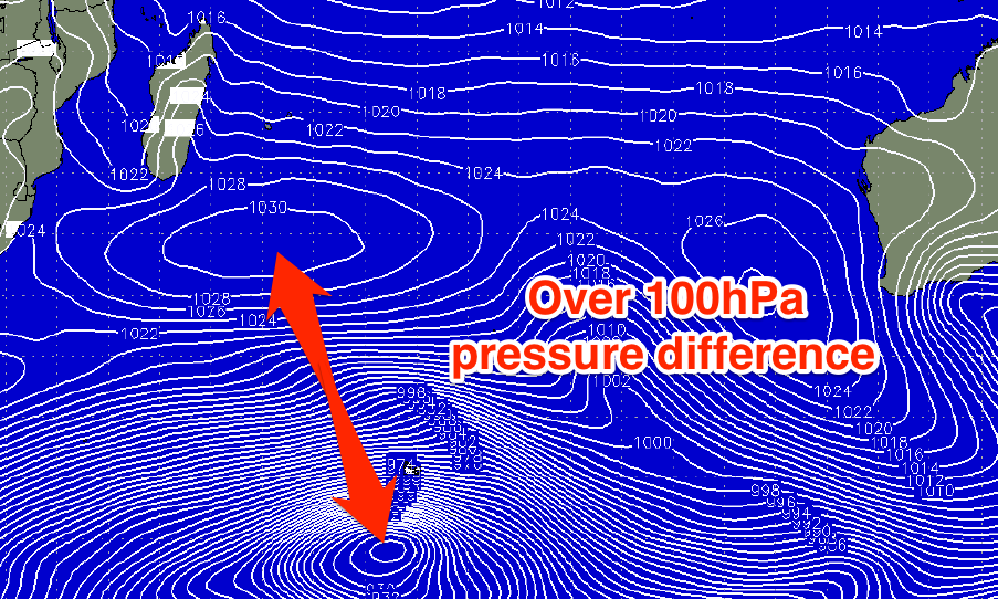 South-east of Madagascar, a strong high pressure ridge is sitting at 1030hPa, with the difference in pressure between the two being greater than 100hPa, resulting in a fetch of severe-gale to storm-force winds (reaching up to 60 knots) at the low's core. This has already been confirmed by satellite observations.
A large and active sea state has been set in motion for a slightly weaker but much more broader – almost the size of Australia - fetch of severe-gales to operate on.
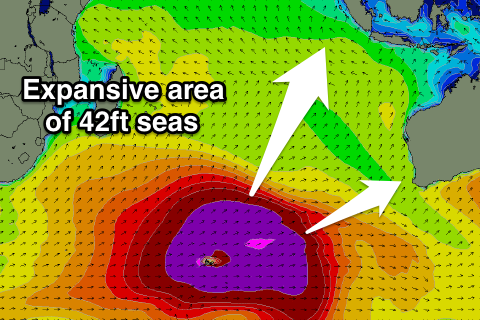
What will result is one of the most expansive swells we've seen for years. At its peak the swell will encompass the entire Indian Ocean basin.
And this is where the really great news for Australian big wave surfers. Just before the swell impacts Western Australia on Friday, a ridge of high pressure will slip in from the west, resulting in variable winds (likely tending offshore, we'll update the wind forecasts in the comments below).
 Margaret River is due to reach 12-15 foot across exposed breaks, while offshore reefs and bommies will be much bigger.
The same swell will then push into South Australia on Saturday under what at this stage looks to be favourable winds from the north-eastern quadrant. Victorian and Tasmania will also receive the swell though the further east the swell goes the smaller and less consistent it will be.
The other amazing property of this swell will be its longevity, with large surf due to be sustained for at least several days due to the magnitude of the frontal progression generating it.
This swell will even impact New Zealand (with no real size or consistency), meaning it will be surfed from as far west as the Madagascar to as far east as New Zealand.
We'll continue to track and document this swell as it develops and provide updates in the comments below. //CRAIG BROKENSHA
Comments
Hey Craig - What kind of swell size could we expect in Vicco ?
Hi Steve,
Forecast is nearly done, and it's super tricky.
The peak looks to be Sunday afternoon with that secondary reinforcing pulse, coming in at a very inconsistent 4-6ft at Bells/Winki. Probably more so 4-5ft with the odd 6ft bomb.
Cheers Craig. Will check out the forecast shortly.
Love ya work !!
Is Mark Matthews going to the right?
Why are you saying its so inco?
Inconsistency is a product of distance from the swell producing storm to the coast you're at.
Western Australia won'e be inconsistent, but from SA eastwards, the swell will become more and more inconsistent.
Oop
Oh no im starting to get that feeling that i need to be somewhere important . The same feeling as when wa got a huge swell last year .
Ha, it's a good feeling.
Back to the womb?
Very exciting!
Craig can you explain if a large period has an effect on the size of surf? eg 2m @ 13s compared with 2m @ 20s? If there is such an explanation.
Cheers!
For sure it does.
Larger period swells contain more energy below the sea surface than lower period swells, and when the swell approaches the shore, all the energy gets compressed, resulting in larger wave heights.
A 2m swell @ 20s is going to produce a lot larger waves than a same size 2m swell @ 10s.
This is the sort of swell that u can get the wave of your life . Swell of a decade . How many spots are going to be bigger and better than ever before
Craig this feeling is not pleasant . When you know your missing something . Now , heard about this thing called croudfunding ?...haha
Craig how about the storm that sparks up sth of sw wa ? Will that give much of a rise in swell ? Its borderline imo at this stage , will it give a spike in swell to wa-sa-vic ? Some sites are showit it . Im mostinterest in is what angle that pulse will come into where im at
Craig imean the fri & sat a front goes into bight giving a boost to swell height
Yeah Camel, that pulse for Sunday morning is the best of the event for your area, fetch is closer and the swell will be bigger, more consistent and also have that boost in size form that storm tracking east-northeast under WA Friday.
Ok well had a closer look using SN wams those things , pretty sure by using the height & periods maps i can see a pulse due to its blue colour flnked by orange / red mostly . You can see massive area of swell in indian . Some of those reefs up there ....
Yeah that kick in period to 19s or so Sunday (purple).
Ok craig thanks did u see the angle ? Borderline loss of swell zone . Will the swellnet site show that boost tmoro ? Cos it doesnt tday right ?
Yeah, should do, and correct, not the best angle with that west in it, but size and period will hopefully override this? Hard to know.
And now the latest from bw , wg ,ww are now showing a sweet boost in size sun
Aha craig , there y are 0k . Wow i wont be crossing the border . Sorted
As this storm passed below Sth Africa did they get monster clean waves ?
Nah, it's only formed south of Madagascar, so too far east and out of its swell window.
Another ski fight caml?haha
Wat sort of ski fight do u mean barley ?
Tides for indo ? Neap tides when this swell arrives there
Nah not neap, shifting between half to one metre or so between highs/lows.
Craig ok right i was told "not good for suk" so thats low at 1pm etc as days go past 2 - 3 pm during this event . Perfect for kuta beach
Paddle v ski..i can see alot of waterhorses sunday..down my way too
Have u seen direct evidence of these guys chomping at the bit ?
Wordis the heroic xxl tow team are going to tow the bombs at a certain big wave where they had to be dragged to by photographer jamie scott last year to surf biggest day in years. They had preferred to eat bacon egg lattes and hope the swell arrived later
Might add that world reknowned j mitchell & mr jeep vis were going on a groundbreaking mission to paddle this wave bigger than ever before possibly to rival the size of jaws peahi by paddling into australias biggest wave.
Trades look light for the peak of the swell too in Indo on Sunday.
Jarryd foster said last month on the oakley asl xxl awards thread . He has "yet to see anyone paddle into a proper cows bomb "
No solid evidence caml..just fb chatter at this stage..
So Craig it's not just the LWT node but more so the adjoining big high pressure system that creates the 100 hPa pressure difference and massive fetch. How can one see this from the LWT plots if at all?
It's a hard one Don, looking purely at the LWT charts, the ridges either side could be looked further into as well, much like the surface pressure but more monitoring in this area has to be done.
Southey, AAO/SAM is actually positive, which is opposite to what you'd expect (negative = westerlies pushing further north in latitude). But this is a global indicator so can't figure out how to apply it regionally..
The positive SAM will let the High maintain its place , strength within the mid latitudes on the average .
So with that the regional /nodal activity will see a compression/pinch in the frontal activity as fronts /lows pass under the LWT node . ( you tend to see long westerly fetches in these setups . They also can elongate out the far( Eastern side ) of that node or in this case drag the nose forward with it a little .
As for the node itself , I tend to look at its off centre axis plus the pulsing (reduction) of it's centre core . There is no tech to that second one , and just observation . The first was gleaned from a snow guru . Where they got disappointed , in a " wasted strong node /2node sequence " where the cooler air didn't track up due to suppression from the SAM . This is when my eyes light up , for surf . As often the high will hold in and even make fronts slide down .
barley wat sort of chatter hmm one guess ok . is he coming to the zoo ?
SST's don . ?
I don't think a big high makes much of a difference as that might only vary 20 hPa .
The depth of the low is more important ( LWT influence ) especially the location . As this also fuelled last weekends swell .
I remember a guy once talking of the strength of the Glaam /SAM index , MJO and LWT . The upper trough will also effect the surface high .
What will this swell do for the Maldives Northern Atolls - is the swell direction right? S - SE?
You're going to get your Willy Wallbridge slotted up there, Cam.
In my personal experience, the North Male atolls don't normally pick up any SW/S groundswell which is the swell direction from this super storm, however given the amazing size and swell period this storm is likely to create, I wouldn't be surprised if you see some highly refracted SW/S groundswell hitting the south swell magnets of the North Male atolls.....probably more so after the forecast peak arrival as that swell swings that touch more south.
Craig,
always fascinated by your comments on these events - many thanks
Heading to Maldives this Saturday - is the system going to move east as per usual and will that mean for the time it crosses under West oz, that the back/western side of the low will pump SE swell up to the Maldives? Any size guess - the forecasts I've seen just show a generic 3ft the next 10 days as if there's nothing happening at all ?
This is a really interesting analysis, thanks. However I find the catchy title "Indian giving" offensive. Bad Swellnet.
Clivus - no Wallbridges a Simon and a couple of Super boards will do the trick!! Need a clue as to identity tho!!
Your old mate from the south now over in the west. Still waiting for you and Al W to visit.
Montalicious. Leaving for the Maldives on the 4th - Al on the way to the Sunny. Some swell on the way - Thursday on here looks good just about everywhere for a few days. Maybe next year a trip west??
Half your luck old boy. I trust you're flying via Goa for some wild times off the end of the jetty.
craig you know that little front that boosts the swell , its aimed at tassie , the models show a swell increase from it . its borderline . wat do u think will it push some swell up my way ?
Would love to - maybe you could show me the ropes. Boring Singapore unfortunately. You in the water much??
The longer period and strong kick Sunday morning is from the huge fetch of severe-gale W/SW winds east of Heard Island tomorrow.
The front heading towards Tassie, is producing a third pulse which is hard to see, for later Sunday.
hard to see you say craig ! not hard mate i been watching it for days. its my business to spot things like that. thats what u need to know about if your hunting big waves .
Yep, onto it!
Change to wind forecast for this swell at its peak - looks like the tradewinds will be strong as per normal
Yeah Mick, strong trades kicking in Saturday, easing off slightly through Sunday.
yeah thats wat i mean craig . that will boost sun arvo where im at
mick are you surfing indo this swell ? nothing wrong with trades is there ?
Hmmmm latest ascat as a fair whack of this fetch quite zonal aligned. Will west Indo and places like the Maldives areas come in under forecast?
I've never really felt this will be an " Indo Swell " .
yeah they will get good waves , but for me WA is primo on this pattern .
There's also one or two things which I won't mention , that have me thinking this . One of them is to do with the SAM index , along with the MJO . Timings wrong .
well from what i can see i dare say outside corner could have #0ft (edit) big waves . isnt this about as big as storms get ?
Alignment is fine for most of Indo, and the sheer magnitude and associated directional spread also helps override the need for it to be perfectly aimed towards the region.
the synoptic chart ( bom ) has plenty of wind aimed at bali . and b.w. has it at 12-16 ft which are the numbers i never saw bigger . (12-16) at bali is usually the biggest of indo swells when g.land is maxed out . rare & fickle breaks come alive .
magicseaweed has a story called "fly to indo now" i thought there was a law against such blatant warnings . anyway they claim the fetch is perfectly aligned .they do say its not the biggest ever indo size foecast. surflines kevin wallis has uluwatu foecast at 15-20 in morning & 20-25 ft in arvo .
Their forcasts are face feet though remember camel, so more 10-12ft+ or so our scale.
Which is around what I'm expecting.
With a unheard of 28 second period.
What size does Gland hold ? are there any offshore bombies along the Java coast ?
Seven waves . Forget G land , would be a mess .
Not sure where the 28s is coming from.
We've got 25s max fore-runners in Indo but with no size, ie 0.2-0.6m.
Then the better 22s stuff at about 1m, but dropping back to 18s as the bulk of the swell fills in.
That's rubbish . ( 28 secs ) especially over 2M height. .
The biggest I've seen is 24-26secs , and that was in the Pacific with a storm created below Tassie sending waves literally half way around the world to Nth America .
Yeah, as my comment above.
Craig,
always fascinated by your comments on these events - many thanks
Heading to Maldives this Saturday - is the system going to move east as per usual and will that mean for the time it crosses under West oz, that the back/western side of the low will pump SE swell up to the Maldives? Any size guess - the forecasts I've seen just show a generic 3ft the next 10 days as if there's nothing happening at all ?
All depends on which part of the Maldives you're heading too.
http://www.swellnet.com/forums/crystal-ball/289021
thanks Don,
am going to North Male Atolls - been to Indo about 8 or 9 times but never really taken much notice of where the Maldives source their swell - I assumed it was the same stuff just bigger period would allow it to bend in there (looks like I chose the wrong time to go Maldives!)
So when you see the photos of largish Maldives waves, is the swell generated from systems crossing further north with the centre bumping straight into WA?
- and your forecast seems to dispel my hopes that the backside of this system will send us something at Nth male At. when it sits under WA?
North Male atolls generally only pick up S/SE swells. They're main source of swells is large semi stationary high pressure systems parked off WA, and whilst these fetches generally aren't overly strong in terms of peak winds, the sheer length and duration (if semi stationary) means they produce some fun waves for the North Male Atolls.
I haven't looked at the backside fetch of that monster storm as it passes under WA to see if it will shoot something up to North Male atolls. I'll take a look at lunch and let you know, but the issue is these fetches are generally not stationary and hence for a decent S/SE groundswell to be produced off the backside of the low, it's gonna be difficult with the low travelling westwards. (If that makes sense).
Based on the latest GFS forecast, there's a brief intensification on the SW/W side of this low pressure system as it approaches WA longitudes, but as I mentioned above, given the low is moving away (to the west) from this fetch on the W/SW side of the low, this fetch has to work on a new section of the ocean, thus requires much more energy to generate anything substantial S/SE swell wise back up to the North Male Atolls of the Maldives. (see brief intensification of the fetch around Friday morning in link below)
http://www.stormsurfing.com/cgi/display_alt.cgi?a=sindi_slp
It's also a relatively compact fetch and a long long way from the North Male atolls, but in saying all of the above, the models are showing a relatively south (190 odd deg) swell to arrive in the Maldives around Thursday 2nd July. Nothing huge but possibly some more powerful 2-3ft+ refracted S'ly groundswell on Thursday 2nd at the North Male south swell magnets. You'll definitely notice the big increase in power in these waves compared to the much lower period SE swell in the water.
You've got a much much better chance from the W/SW flank of the semi-stationary low developing in the central Indian Ocean around Mon 29th/Tues 30th June IMO. This swell looks to arrive in the North Male atolls around Sat 4th July. Based on current forecasts (again, these are just forecasts and haven't actually occured yet, I reckon the south swell magnets of the North Male atolls could see some fun 3-4ft+ from this low pressure system storm around Sat 4th July (if the storm comes to fruition).
cheers Don
Welly, if your still in contact with 'Nganhurra' captains some readings from this sat sun would be good.
udo i dont think g.land will hold on west swells it maxes at 8-10 but south swells it holds 12-15 ft . the wave called chickens down the end will be good tho . craig yeah i see kevins surfline forecast is face size . you call the average height tho but for
me i often call the size of the single most biggest wave of the day because when u are targetting those sets that is the potential size u could surf . so my call of 20ft ulus means maybe just one wave biggest one all day / all swell . remember the photo of jim banks on an ulus monster ? well how bigs that ? that sort of thing might roll in saturday
Ah yes, same for WA, I think most exposed breaks will be in that 12-15ft range, but offshore bommies are likely to see 25-30ft sets.
Is there a new indo forecast coming? Looking at after this event...
Hi Gibbsy, sorry was a little busy yesterday, yes there'll be another one tomorrow.
Cheers mate, trying to make plans between swell froth n mrs time, few spots wanna get to in next couple weeks :)
Camel yep I'm in Bali. Got compressed on Saturday so I've done my medial ligament just a strain. Struggling to get on it but will try. I can probably go straight eh. Lot of talk of crew going to Nias and bailing to other breaks. Tides not that low for the Outside Corner. At the lowest its only 0.6m Sunday - its perfect Ulu Bombie swell, with a bit of water on it all day.
I'm worried about the winds when the midday low tide...the biggest waves always seem to come with the wind here - old Myth
Size wise these photos from October 2013 3.2m @ similar period
Also Camel I was thinking of the right hander in the Gili's but the window will be tight - one sessions first thing Sunday and then winds will be onshore.
that right is a nice little escape mick . your knees gotta get better fast !!! winds arent a problem when your surfboard has the paddle power to claw your way into the swells .have u checked out the desert storm models yet ? they paddle into anything ! the best & biggest advantage for paddling into heavy waves youll find .
Haha I know was thinking a little 6 foot wave as opposed to 15 foot would be better for the knee. I have heard that right is one of the amazing waves in Indo but needs huge SSW swell, wet season winds (sits on SE side). Plus I left 8'6 and 10'1 at home but have my Bushman 7'7 Camel, so a lot of froth ! yes and that desert storm model board looks incredible.
Who is paddling Cow?
That you mick?
Yep! What's happening? you been getting waves down your ways?
Nice pics! I'd love to surf outside corner. What size board are you on there?
Yeah had a couple good days here and there.. Few little day trips too. Can't complain. Hope the knee heals up in time for you!
Sorry mate that wasn't me surfing by the way. I thought you were talking about meeting you that day out at Sunset. You're from Mornington Pen eh? Think I said gidday. Photos are from a mate Tim Morry of unknown surfer. I was surfing indicators in Java same day so was good to see the size difference on the day. Outside corner was 12-15 and where we were surfing was 10-12. So like Camel says its a magnet eh? That day being a 3.2m swell and that's 4x overhead. I guess with 3.9m swell it's going to be legitimate 15-18 feet so 5x overhead.
mick theres a few crew hoping for a paddle but the wind is favoring tow only . hopefully the wind eases at some stage. plenty of big waves in indo like ulu & java & many more . remember the pic of tom carroll on that left (said to be enggano) & rcj had a two wave hold down .? that one will be doin its thing . funny how indo is mostly known for small waves these days
That's quite cheesy sales pitch for your own model on the forum . Just saying ,fairly amusing :)))
funny you say that Shaun, you come across as the type of person who would have a shower shot of yourself covered in Frank body scrub somewhere in ur Insty, maybe in-between the coconut water drinking pic and SUP action photos.
Oohhhh no, even to ugly for my càmera yocal ,
Craig /or others, what effect will the strong easterlies from northern WA have on this swell in indo? It's probably going to be 20+ knots easterly blowing. Accompanied with maybe 2 metres of Easterly swell. I was just wondering if this has much of an influence when the smaller swell meets the larger one at right angles? Does it chop the larger swell up or anything like that?cheers
Zero to nil effect in terms of the easterly windswell affecting the solid groundswell marching up to Indo.
Thanks don!
west oz already has 22 sec fore runners finishing their marathon race to the finish line . e.t.a. was correct for these guys to arrive
Yep, here they are Cam!
If I'm reading that right is it saying 2.35m@22 sec? And that's the forerunner!!!
No, it's a mix of short-range W/SW swell also on the build and the fore-runners.
Hard to seperate the two unfortunately.
Since then though the groundswell has really kicked with east 8ft sets across the Margaret River region.
How's the direction difference and size between Naturiliste and Rottnest wave buoys . ?!?
Yeah crazy, more west at Rottnest than Naturaliste. Bathymetry steering it more west into Perth??
Margaret River..
A lot of motion in the ocean at Margs. Seems quite west - heaps of Big ones at Bombie - almost closing with Boat ramp already. If this is the start and its going to get heaps bigger, the SW will be a wash out.
Crikey, will have to bust out the 9'0 in Bunghole!
Well and truly on the pump now!!!! What's tomorrow going to be like?
how does 5.25 m @ 20 sec sound this morn ? suppose that secret offshore bombora 15 km off augusta named "seldom breaks " will be breaking ! where are there going to be rideable waves today ? would be cool to cruise the cape region having a look tday. there could be a few more "seldom breaks " to be seen
With it kicking so strongly yesterday, be worth keeping an eye out for a late one over your way for sure.
Winds have gone light SE at Cape Naturaliste this morning but were still fresh onshore until about 10pm last night. And, it's still gusting 20kts from the S/SW at Cape Leeuwin right now. So I'd expect rather lumpy conditions across exposed spots north of Margs this morning, and bumpy/choppy south of Margs (but with an improvement during the day).
Some big sets pouring through Yalls late yesty arvo.
yes craig im on way .it seems to be arriving with more size and earlier than predicted where im at . albany has just dived a metre atm . looks like the forecasts wont be spot on so we just have to see as it pans out . stay safe surfers wear your floaties
How's this smoker, captured randomly from our Yalls surfcam.
Some huge sets pushing through on the Margarets cam too.
Quick question for those who know the area - it looks like there's some white water on the horizon just to the right of centre when the cam is pointing at Main Break (?). Is that one of the offshore bombies breaking in this big swell?
Hmm, I'll have to check it out. Certainly haven't seen any cloudbreaks on the Margs cam before, but if it's gonna happen, this is the swell for it!
There are a few odds and bobs that break out from, and North of the Box, plus out the back of Mains. These may be showing up. Plus, roughly where the channel is between Box and Mains is a shallower reef where the swell definitely feels the bottom. It may have something but it would have to be huge. When we have travelled through there on the ski, the swell stands up a bit, although I have never seen it even close to breaking. The odds and bobs have surf able waves, but are really shifty and break onto super shallow reef, or just in front. I have done a fair bit of tow surfing in the area and we have never really considered any of them as they are a little too dangerous and hectic for us.
Jeez, it's big at Yalls.
Lol. Yals was going to be where I was hiding from the brunt of it. Looking at that I may have to reconsider the after work surf.
West coast S.A. bombies ...........Craig , Ben or Caml care to put a size on what YB may be over the next few days ?
Im calling much bigger than that steamroller that Dean Bowen straightened out on in the Noodles comp.
North Point ooking solid http://iconosquare.com/p/1015505560252488329_43389645
That was a sic one!!!! I read Taj & co were on it early towing........
Yeah solid, but this news hype talking 1 in 10 year swell is not right.
It's big and pro-longed but there's been larger swells in the past 5 years, plenty.
Here's a solid one taken from our cam, looks 4-5x overhead!
Look very closely to see the surfer, and a little scale I put next to him.
Totally agree Craig. The media over here have gone berserk on this swell. Glad you used the word "hype", last time I used it I got howled down.........
Thanks for great forecast on this one and those pics!!
This whole forum topic is hype..what do you mean craig? You guys have talked it up...
Big swell yes, 1 in 10 year event no.
Barley I'm pretty sure that SN is a lot more factual in their reporting .
They also have some form of " social conscious " when it comes to delicate topics .
( especially facebook ) . But let's not start self felating !
SN is often one of the first to often " ignite " the fire with inside tech. knowledge far exceeding many other sites . [ they could also point out that the informed readers contributors in here don't expect any less than excellence ] ......
But whilst this fire is lit they may not be fueling the rampant bushfire that has appeared today , throughout all media including MSM . So I think they are the less of the present evils , but would fall short of them being deemed a Fire retardant . That my friend is up to us Joe Publics like you and I , to condemn and belittle some of the more outlandish comments being made in this topic . I think I might even start a Forum thread .
TB ( taj ) is first in my firing line ..........
Spill your beans Southey. I heard him say there were some fun ones......
.
I must of missed it Barley. What do you mean by SN talking it up beyond what we're actually seeing? Enlighten us mate.....
If the break in front of my shack gets to 6ft..then all is right..atm its 2-3 but very fun
Sounds like a case of one surfers 6ft being another surfers..............
If the title isnt enough..re read the rest of the article..huge swell..amazing..madagascar to new zealand...technically they might not of said 'swell of the decade' but if you had to pump tyres up its a fair way to go about it...dont ya reckon?
Rabbits if the break in front is 2-3 the one over the hill is 5-6ft and the next hill is 8-10
I like the sound of your shack Barley. Enjoying the view no doubt mate :-)
SA its ok - vimeo......Barley those bastards have been over the hill ...again.
An incident at Cow bombie earlier, any news ? ?
According to Twitter, Justin Holland broke his left leg
https://instagram.com/p/4awYUiJ93d/?taken-by=mysurftv and the wave that did it
Fwark, people saying it's the femur.
ABC online have a bit of blurry footage of Justins mow down.
Snaketales instagram pic of Ulu today.
by the looks of that wave wat have u got to say now naysayers
Craig/Ben,
I notice during this event the huge distance from west to east of the high pressure sitting above the low that traversed the Indian ocean and it's shape in general.A flattened out high pressure with a wide west to east point as opposed to a lot you see in a synoptic chart that are more round in shape and smaller in width.
Can this be a factor in the massive fetch?
A high pressure of similar shape in some models over the south Atlantic in the next week or so?
Thanks
About dozen guys having a dig at Ulus at anyone time.


The missus got a couple of snaps.
Ist one Phil Carson, 2nd one Rahtu. Johnny Dee got a crazy one giant barrel.
Built during the day with 10 - 12 foot with bigger ones.
Also I bailed from Ulus at 2:45 so I'm not sure if it came up to 15 foot as per the forecast. It's been howling trades. Tomorrow may be a little less windy
trades are good mick . great pics thanks mick . i saw some other epic ulus pics lookin so perfect . sorrell buoy is on the up . w.a. buoys offline fuckit bastards haha now i cant predict so good for tdays session.
Mike Hunt taken by Jamie Scott.

wow, that Ulus looks beautiful. How were the lulls between sets Mick?
Watched Balibelly wave cams Bingin, Kuta, Keramas and Canguu thru most tides yesterday and sets seemed to be every 15-20 mins and nothing in between....saw the pack at Bingin moving quickly to the right of the screen for deeper water then Bam a dozen or so 8- 10ft plus bombs go thru....awesome.
Where was that photo taken camel?
Ding D, Cow bombie.
Lots of W.A. Indo pics on surfline.
Righto looks hectic
Thats a big wave alright. but then again it's a big state! Go earplugs!
Anyone help out on where this is in. Tassie . Travelling solo there so I won't really effect the crowd
Don yesterday 20min lulls reckon today 40mins. Far from perfect but occassionally the waves were just crazy. Same size today with the Bombie some legit 15 footers but barrells still collapsing. Its difficult because you never know what you going to get. Back peak is the best. Tide too high even at low tide for the corner - shame
Seen the photo of the broken femur....heavy
http://tenplay.com.au/news/perth/2015/6/27/swell-of-the-decade