Incoming swell for Indo: largest of the season
 At the end of this month the largest swell of the year thus far will hit Indonesia. It's impact will be felt the length of the archipelago from Aceh to Rote Island, and even Australia's west and south coasts all the way to Tasmania, will receive swell. It is, by any standard, a huge system.
Last year Indonesia had a banner season with a consistent run of large swells making landfall. In contrast, this year is best described as 'fun' with plenty of moderate sized swells under favourable winds.
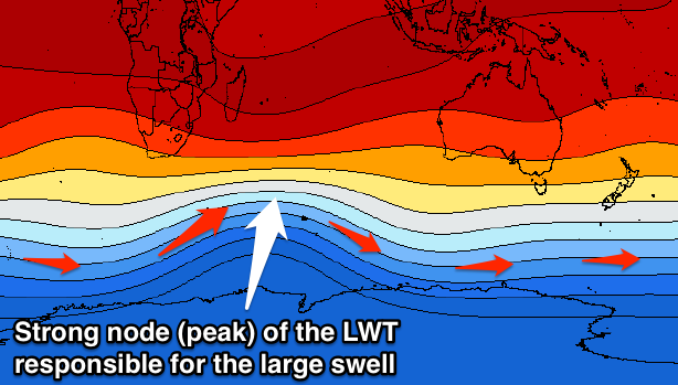
This swell will break the pattern and it's all linked to our good friend the Long Wave Trough (LWT).
 A strong node (peak) of the LWT is forecast to move into the south-western Indian Ocean from Sunday. What this effectively does is strengthen and steer polar frontal systems up along a similar track to where the node is positioned. And this, fortunately, is plum centre for Indonesia's prime swell window.
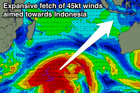
This is what the weather models are currently forecasting, with an initial burst of storm-force winds setting in motion an active sea state for a much broader and elongated fetch of severe-gale to move over.
The fetch will span over 2,000 kilometres and be slow moving, resulting in a large, long-period SW groundswell for Eastern Indonesia (The direction will be more S/SW in Western Indonesia).
There'll be several embedded pulses within this large swell event, but a peak is due over the weekend of the 27/28th of June, more so Sunday to the 10-12ft range with 15ft bombs at exposed breaks.
The large swell period will likely focus the swell into selected regions, and away from others, but where these areas lie is still an area for further research.
We'll continue to monitor this storm as it evolves and provide any changes to the size and timing in the comments below. //CRAIG BROKENSHA
Uluwatu Forecast Graph
Uluwatu WAMs
Mentawai Forecast Graph
Mentawai WAMs


Comments
Forget Indo, what's this going to be like when it hits SA later in its life?
Very inconsistent, but still large and strong when it comes.
Craig, aside from this can you please explain why Perth doesn't receive much swell and the Margaret River region does?
This is mainly due to the blocking effects of the various outer reefs and shoals along with Rottnest Island. The swell also has to travel more distance compared to Margaret River resulting in more swell decay, and also slight loss of size from frictional effects from the continental shelf (ocean floor).
Awesome! Thanks Craig :)
The sheer length, intensity and duration of this fetch is very impressive!!!
Would like to know how this LWT node is different to others. Is why is this fetch so long and intense.
Cool your jets people. At this stage it's just a forecast and the storms don't actually exist yet. Predicting wave heights 10 days out is a tad premature.
Having said that, if these storms become a reality (3-4 days from now), it might be a good time to throw down the cash for a plane ticket and dust off my 7'8". It sure as shit hasn't been getting wet in Vic for the last 2 years.
I see why you'd think this.
But 10 days for Indonesia is quite easy, especially when as you said the storms are due to only develop in 4-5 days time, along with the favourable upper level steering indicating a very large polar frontal progression.
Timing and size is harder at this stage, but there'll be a very large swell at the end of the month with this forecast setup.
Call me old fashioned but I still want to see an actual storm before making predictions that far out. See you point re Indo being easy to predict. It's not like there's a lot of land mass blocking any swells before they explode on those beautiful reefs.
Totally, me too.
4 days out with ECMWF and GFS in agreement.....I'd say it's a pretty safe bet. Put a few feet +/- on heights but either way it's going to be a big swell.
What I see in this one compared to others is the stronger overall gradient between the thickness levels and it's broad and drawn out coverage over the southern Indian Ocean, instead of a more pronounced northward protuding node.
I think this is why the storm is so broad and expansive.
Will it get to Victoria or is it going to fizz out at WA?
Yeah it will get to Victoria but be smaller and less consistent. Still looking at a moderate to large W/SW groundswell.
Thanks
W/SW from this far out in the swell window will barely register on the Surf Coast. Looks like one of those sets every 20 minute swells. I've found that those 16 sec + swell periods are so inconsistent on the Surf Coast. Better value elsewhere.
This will be a little better than that, as the secondary stages of the frontal progression will continue with strength to at least WA and likely further.
Craig, It's way too early to be calling a Vic swell from this forecasted system. Indo dubious, Vic? Pulease. Sorry but Swellnet regularly overcall swells for Victoria from storms way to the west of WA. This storm hasn't even formed yet, and you're calling swell for Vic multiple thousands of kilometres away ten + days out. Our lineups are crowded enough as is. You guys make it so much worse with crazy OTT surf forecasts like this.
Not saying it's a great swell at all, as you've said W/SW, inconsistent and from a long way away. But I think it'll be better than you think, as the storm actually continues with intensity under WA.
Just pointing out that it will be better than an inconsistent 20 minute wait between sets swell. But also a lot can change for Vicco this far out, hence your warranted hesitation.
Will belt the east coast though with W/SW it is direct. Sounds like it is going to be way too big for the beachies.
craig this is a tad off track though do you see any scope for this swell affecting the Maldives region (will be there late june and first fews of july)
How late June? You'd want to be there 26-28th. The Southern Atolls for sure. Male region, small, inconsistent refracted groundswell.
Am there 22 june to 2nd july - doing central atolls though some spots do well on SW swell winds permitting. thanks for the feed back craig - fingers crossed
Craig, How do you think Simeulue will fare with this swell size wise, we arrive there Sat 27th in the am, cheers mate.
Very big there as well, luckily you're getting there in the morning, swell's due to really kick through the afternoon.
Good luck with the crossing......hope youre going by air.
Ooooh yeah, nasty...
haha. fuck yeah. i spewed last month on it and it wasn't even solid. just stormy hahaha
How'd you go out there Mibs?
Scored some pretty sick waves. My slack ass grommy mate was supposed to give me his fav shots to pass onto you. I cbf'd chasing it up now. I got a few pics on my Instagram @its_mibs have a look mate
Ha ha...too many barrels!
Too many and barrels shouldn't be used in the same sentence unless it's followed with 'are going unridden'!!!
Hoping to get a sequence sent thru from the last day at ht's. Or if any lads who may read this were on the dbora got some hook us up!
What a bummer I just happen to be on my way to Bali next Thursday. With two
new boards.
Frothing!
Craig, Im in the mentawais this week.. What day is it going to hit Playgrounds area? and how big you reckon?
Building rapidly on Sat peaking Sunday.
Get in on Monday. Trying to change ticket.
So what's the info on this swell, can someone tell me about the crossing from bali to nusa Lembongan. I've got An idea on what it could be like. But I'm meant to cross on next Tuesday. Then off to gillis 3 days after with the mrs.
Swell will still be large Tuesday but on the downwards trend and nothing like later Saturday/Sunday.
Not sure what the crossing's like, but I think you should be OK.
How quick you think it will drop, and to what sort of size you think? Still tossing up throwing the dosh at a flight change from monday to saturday.... i too gotta fit/try to get out of some gilis time with the missus at some point....
fuck i've only got a 6'5 at the moment ..........
Right in the path of this Indo bound swell lies Cocos Island, Who's surfed it ?
Diego Garcia should also get some.
Cocos is amazing. You should go there.
Ah ha I new you would be the man to comment on Cocos, have seen lots of pics from a friend that lived there for a few years.........that lefthander ye ha.
This system looks impressive on Earth Null...tis about the size of Aust.
Aaron Hawke tumblr, pic of a wave at lacerations from a 19 sec period swell in 2014.