Good swells inbound
Monday, 14 April 2025

Good swells inbound
Monday, 14 April 2025
Persistent winds from the north-eastern quadrant and fun swells are due all week.
Persistent winds from the north-eastern quadrant and fun swells are due all week.
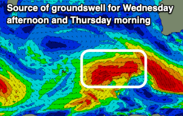
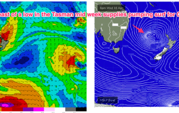
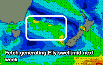
We’ve got a very dynamic week ahead, anchored by very strong high pressure moving into the far-southern Tasman and acting as anvil for a deep low which is expected to form in the tropical South Pacific between New Caledonia and Vanuatu o/night into tomorrow before drifting SW into the Tasman as a deep, extra-tropical low pressure system. This system intensifies through the week and is now expected to generate a large E’ly quadrant swell for the Eastern Seaboard heading into and over the Easter weekend.
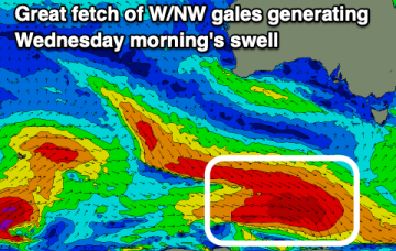
Wednesday morning is the pick of the week as the incoming swell builds, best in protected spots as it eases.
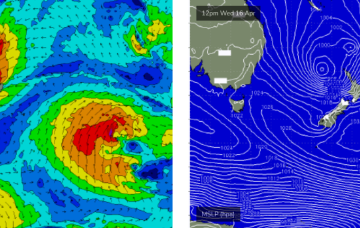
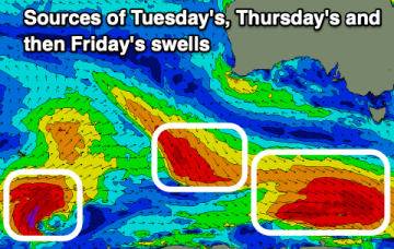
Certainly by Thurs the synoptic chart should look insane with a deep low (970-980hPa) retrograding into the Tasman, positioned inside the North island with plenty of space for severe gale to low end storm force winds to be aimed up at the east coast.
Conditions will be great this week across the South Coast with plenty of fun sized surf, with a small west swell to end the week inside the gulf.
The coming period will be cleanest on the beaches with better swells than what appear expected.
The Sunshine Coast is best positioned for this swell (relative to the fetch alignment) and so will pick up the most size.
It's a bit of a tricky weekend of waves, but the short version is there should be something fun and it’ll be clean on top.
The coming period is a bit hit and miss but the middle of next week should offer a wave.
The weekend looks fun each morning ahead of a good pulse of S/SW groundswell Tuesday.