Fun tomorrow, slower thereafter
Wednesday, 20 July 2022
Fun tomorrow, slower thereafter
Wednesday, 20 July 2022
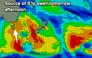
The best, most consistent swell is due tomorrow ahead of more distant, west energy on the weekend and early next week.
The best, most consistent swell is due tomorrow ahead of more distant, west energy on the weekend and early next week.
There is tons of swell inbound for the state but the South West will battle with onshore winds.
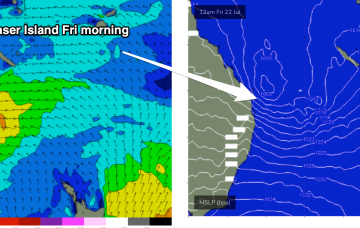
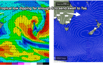
By Friday we’ll see the Coral Sea low looking very impressive on the map and an E’ly fetch extend down into temperate latitudes. The low centre is expected to be NE of Fraser Island with E’ly gales aimed straight at SEQLD.
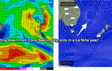
The basic building blocks as we described them in Monday's notes are now in place for (another!) dynamic La Niña mediated surf/weather event. A dominant high pressure system (1034hPa) is strengthening as it slowly crosses Tasmania, a typical Summer latitude for high pressure. The remains of a low near the South Island are continuing to send south quadrant swells our way and most notably a trough of low pressure in the Coral Sea is deepening and expected to activate into a fully fledged Coral Sea surface low as an upper trough moves over it from inland QLD tomorrow.
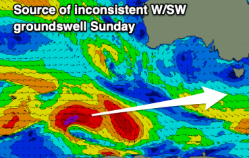
Smaller pulses of swell for the coming days ranging from south to west, with larger surf developing out of the west next week.
Fun swells with clean, lined up conditions and decent options right through until Monday.
Surf comes from a wide variety of sources this week as a typical strong winter cold front gets shunted aside by a very La Niña looking synoptic pattern, more reminiscent of Feb/Mar than July. This will see a very strong southwards located high pressure system set up a strong ridge along most of the Eastern seaboard, acting as an anvil for a tropical low to push against later in the week
Improving weather and winds with plenty of energy hanging in from the south.
Typical winter set-up gets shunted aside by a very La Niña looking synoptic pattern this week, more reminiscent of Feb/Mar than July.
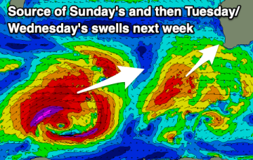
Tomorrow will be the cleanest before we see a series of strengthening lows and cold fronts pushing up into us, bringing XL swell next week with workable winds.