Plenty of swell with varying winds
Monday, 11 July 2022
Plenty of swell with varying winds
Monday, 11 July 2022
Lots to choose from this period with varying winds and swell pulses.
Lots to choose from this period with varying winds and swell pulses.
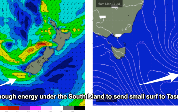
The remnants of the Tasman Low (ex ECL) are now drifting near the South Island, on top of a large high which is slowly moving out of the Tasman Sea. A high is approaching from the South Australian interior, with a trough expected to form off the coast later Tues and develop a broad, relatively weak low in the Central/Northern Tasman.
The remnants of the Tasman Low (ex ECL) are now drifting near the South Island, on top of a large high which is slowly moving out of the Tasman Sea. A high is approaching from the South Australian interior, with a trough expected to form off the coast later Tues and develop a broad, relatively weak low in the Central/Northern Tasman.
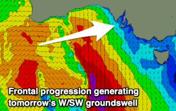
A new westerly swell with cleaner conditions is expected on the Mid Coast tomorrow, with options down South.
The remnants of the Tasman Low (ex ECL) are now drifting near the South Island, on top of a large high which is slowly moving out of the Tasman Sea. A high is approaching from the South Australian interior, with a trough expected to form off the coast later Tues and develop a broad, relatively weak low in the Central/Northern Tasman.
Nothing stands out this period but there'll be a few small days for the keen.
Poor tomorrow but better Sunday with a rare E/SE groundswell and OK winds.
Building wind and surf on the weekend, largest Sunday afternoon but improving quickly while easing Monday.
Improving tomorrow with a mix of swells, best Sunday with easing size. A windy change is due Tuesday with some new westerly swell.
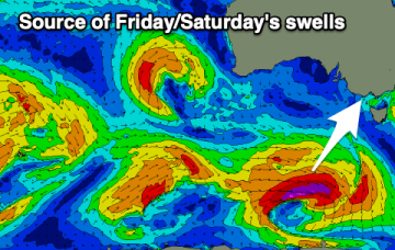
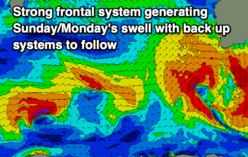
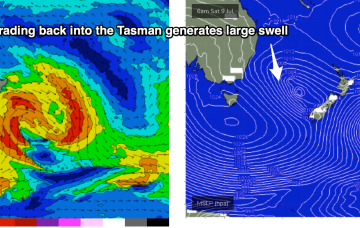
The new trough/low is generating gales out of Bass Strait and up towards the South Coast. The main low is drifting towards the South Island and intensifying today, with gales to severe gales expected to retrograde NW back into the Tasman Sea (see below), generating a large swell for Sun/Mon.