Fun tomorrow, slower thereafter

Southern Tasmanian Surf Forecast by Craig Brokensha (issued Wednesday July 20th)
Best Days: Tomorrow, Friday morning beginners, Sunday, Tuesday for the desperate
Features of the Forecast (tl;dr)
- New S/SW groundswell tomorrow AM, easing into the PM and further Fri
- N tending E/NE winds tomorrow, fresher N/NE Fri
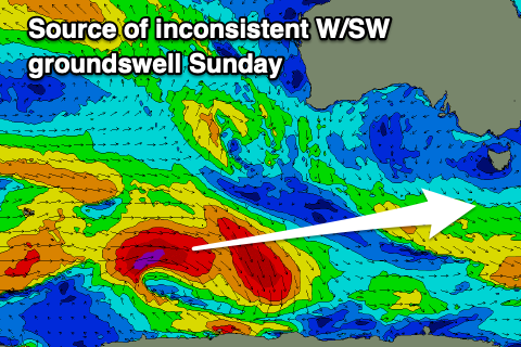
- Inconsistent, small W/SW groundswell Sun with NW tending light S winds
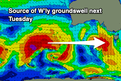
- Inconsistent W groundswell Tue with N/NW tending W winds
Recap
Great conditions yesterday and plenty of swell out of the S'th continuing at 3-4ft, with a reinforcing pulse for the afternoon maintaining 3ft sets. Today it's dropped right back in size but was nice and clean again.
This week and weekend (Jul 21 - 24)
 Tomorrow morning will be the pick of the end of the week with a new pulse of S/SW groundswell and offshore winds.
The source of this swell was a polar fetch of W/NW gales and we should see 2-3ft sets in the morning, easing through the day and back down from 1ft to possibly 2ft on Friday.
Conditions will be favourable with a N tending E/NE breeze tomorrow, then fresher N/NE on Friday.
Moving into the weekend, Saturday looks tiny, but a small, inconsistent W/SW groundswell should be seen on Sunday. This was generated by a distant but strong polar low to the south-west of Western Australia today and should provide infrequent but fun 1-2ft sets across Clifton.
 Winds look nice early Sunday and light N/NW but a trough looks to bring a shallow change through the day, though only weak onshore into the afternoon.
Longer term we've got a flurry of significant polar storms projecting up towards Western Australia but through our western swell window.
This isn't ideal but infrequent levels of W'ly groundswell are due through next week from Tuesday, with a possibly larger, local source of swell Wednesday/Thursday. More on this Friday though.