Large to extra-large swells inbound

Western Australia Surf Forecast by Craig Brokensha (issued Wednesday July 20th)
Best Days: Early Friday for the keen Perth and Mandurah, Perth and Mandurah Sunday, protected spots in the South West Sun AM, Wednesday, Thursday
Features of the Forecast (tl;dr)
- Weak windswells tomorrow with strong S/SW winds, abating
- Easing W swell Fri with W tending W/NW winds in the South West, N/NE-NE early in Perth
- Strong NW tending W/NW winds ahead of a PM change Sat
- Moderate sized SW groundswell Sat AM
- XL W/SW groundswell building later Sun (large AM) with moderate S/SW winds, easing and tending W/NW into the PM (E/SE tending NW winds Perth and Mandurah)
- Easing swell Mon with strengthening NW winds
- XL SW groundswell building Tue PM with strong W/NW winds
- Easing swell Wed with E/NE tending S winds (Perth and Mandurah), S tending S/SE in the South West
- Easing surf Thu with E tending SW winds
Recap
A small start to yesterday with clean conditions but 3-4ft waves max across the South West, 1-2ft in Perth and Mandurah but fun. A new, inconsistent W/SW groundswell didn't really come up to the size expectations across the South West into the afternoon and this morning we've got wind affected and deteriorating 4-5ft waves. Mandurah was a bumpy 1-2ft with a little more size reported across Perth to 2ft.
Conditions are now deteriorating across all locations as winds strengthen from the N-N/NW.
This week and weekend (Jul 19 - 24)
The end of the week looks poor for surf across the South West, with a strong S/SW change due tomorrow morning as the trough moving in from the west crosses us.
It looks even poorer for swell generation with no decent swell due across either region.
Friday will see a weak mix of easing windswell and mid-period energy with lingering onshore W tending W/NW winds across the South West, NE-N/NE early in Perth and Mandurah. Size wise expect a peaky, weak 2ft wave.
From the weekend we'll see a much stronger and more significant polar frontal progression developing under the influence of a strong node of the Long Wave Trough to our west.
Firstly, a new SW groundswell is due Saturday morning, generated by a strong polar low that's currently south-west of us but the first in the more significant fronts will be approaching us, bringing poor, strong NW tending W/NW winds ahead of an afternoon SW change.
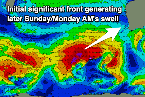 This front will begin its life as a polar low, west of the Heard Island region tomorrow, generating a fetch of severe-gale W/SW winds while projecting slowly east-northeast towards the state, across us on Saturday evening.
An XL swell is due from this front on Sunday afternoon with building sets to the 12ft+ range in the South West by dark, 4-5ft in Mandurah late and 4ft Perth. Conditions will be best to the north of Margs with E/SE offshore winds, shifting NW into the afternoon but only light. Protected spots in the South West look workable but ahead of the peak of the swell with a moderate S/SW breeze in the morning, easing and then tending W/NW into the afternoon, strengthening later.
The strengthening NW'ly will be ahead of the next significant front with easing surf but poor conditions due on Monday across all locations.
The next frontal system will produce another great fetch of severe-gale SW winds more in our south-western swell window, generating another XL pulse of SW groundswell for Tuesday afternoon.
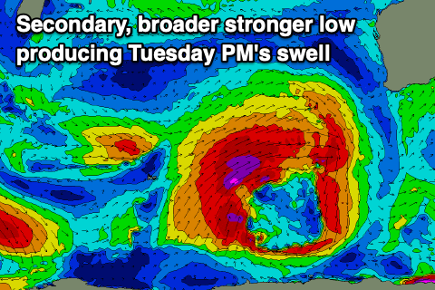 It looks to possible be a touch bigger than later Sunday's but winds will again be poor and strong from the W/NW.
Conditions should improve and clean up from Wednesday as a high slides in from the west, bringing S tending S/SE winds in the South West with light E winds for Perth and Mandurah along with easing 10-12ft surf in the South West, 4ft across Mandurah and 3ft in Perth.
Thursday could be even cleaner as the swell continues to drop but we'll have a closer look at this on Friday.
Longer term, the fronts will move back in later week bringing more large surf and onshore winds into next weekend and beyond. More on this Friday.