Great run for the beaches

Victorian Surf Forecast by Craig Brokensha (issued Wednesday 20th July)
Best Days: Beaches today and tomorrow, Friday exposed beaches, Sunday and Monday exposed beaches
Features of the Forecast (tl;dr)
- Inconsistent S/SW groundswell tomorrow with N/NE tending E winds
- Easing S/SW groundswell Fri with strengthening NE winds
- Low point in swell Sat with strong N/NE winds
- Possible very small W swell showing later Sat
- Inconsistent SW groundswell Sun with fresh N/NE winds, easing Mon with stronger N/NE winds
Recap
Monday afternoon's large pulse of S/SW groundswell was still solid across selected breaks yesterday morning on the Surf Coast, but mostly 4ft around Torquay and with a poor easterly breeze.
To the east the swell was too big for the beaches but cleaner, better into the afternoon with a little less size and better tides.
This morning we've got cleaner conditions across all breaks but there's lots of south-easterly lump and roll mixed in with the easing longer-lined swell. Sets are easing from 3-4ft on the Mornington Peninsula and 2-3ft to the west.
This week and weekend (Jul 21 - 24)
Tomorrow morning should be much cleaner and more lined up across the beaches as the localised windswell signal fades and better N/NE offshore winds blow across the regions. Winds are due to swing light E into the afternoon, keeping conditions fun east of Melbourne.
Swell wise, we should see a new pulse of tricky S/SW groundswell, generated by a healthy but poorly aimed fetch of gale-force W/NW winds on the polar shelf. There'll also be a very long-range W/SW groundswell in the water but this hasn't shown well across Western Australia so keep your expectations low.
The Surf Coast should be mostly 2ft with the odd 3ft'er on the magnets tomorrow, 3ft to occasionally 4ft to the east.
The swell is due to ease Friday from 2ft and 3ft respectively to the west and east as NE winds blow all day, a little stronger into the afternoon.
 Looking at the weekend and the swell will bottom out on Saturday with tiny Surf Coast waves, maybe 1-2ft to the east and strong N/NE winds will favour the exposed beaches.
A small, flukey pulse of W'ly swell from a low dipping south-east from the Bight looks very minimal in size. Late in the day Saturday the Surf Coast magnets may see a 1-1.5ft wave, with 2ft to possibly 3ft sets showing to the east.
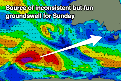
A more reliable but inconsistent SW groundswell is due on Sunday, produced by a distant polar low that's currently south-west of Western Australia.
A fetch of gale to severe-gale W/SW winds have been generated and this should provide infrequent 3ft sets on the Surf Coast magnets Sunday, with 4-5ft waves to the east. Conditions look to remain great for the beaches as winds ease and hold from N/NE all day, stronger on Monday as the swell eases.
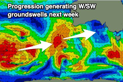 Longer term, a progression of strong polar storms will push up towards and then under Western Australia under the influence of a strong node of the Long Wave Trough, bringing moderate sized pulses of W/SW groundswell for us from Tuesday.
Winds look favourable and out of the north-western quadrant but we'll have another look at this Friday.
Comments
Da Bone and GF you're on!
the east is having an all time winter!!
Don’t count ya shacks till they pitch. Seeeshhh!!
Do have some mighty fine beach breaks. Get shacked ya lucky bastards