OK surf tomorrow with larger, mostly onshore surf developing from the weekend

Western Australian Forecast by Craig Brokensha (issued Wednesday May 22nd)
Best Days: Tomorrow morning in the South West, Perth and Mandurah early Sunday, Monday selected spots
Features of the Forecast (tl;dr)
- Inconsistent, moderate sized W/SW swell tomorrow with moderate E/NE tending NE then N/NE winds
- Easing swell Fri with strengthening N/NE tending N/NW winds
- Large mid-period W'ly swell building Sat with a SW groundswell also into the PM
- Strong W/NW winds in the South West, a little weaker to the north Sat
- Large W/SW groundswell building Sun, peaking overnight with strong N/NW winds in the South West, moderate N/NE early to the north
- XL swell likely Mon with variable S winds
- Easing swell Tue with strengthening W winds
Recap
Weak levels of windswell yesterday morning were replaced with some new W’ly swell into the afternoon, best across the South West with variable winds and 3-4ft sets.
The swell has held this morning with cleaner conditions across Margs, clean also to the north but tiny.
This week and weekend (May 23 - 26)
The westerly swell seen the last day or so is expected to become stronger into tomorrow, with a more distant source of energy due to arrive, providing better 4-5ft sets across the South West while Perth and Mandurah persist to 1-1.5ft.
Winds will shift from E/NE to NE and then N/NE during the day, favouring selected spots.
Easing surf with a quick shift in winds from the N/NW to a strong N/NW’ly will make Friday a lay day, while also signalling the arrival of the first in a series of strengthening frontal systems moving in from the west.
We’ve got a hive of activity due over the coming week to our west as a series of strengthening frontal systems push one after the other, up towards us, under the influence of a strong node of the Long Wave Trough.
This will bring a general west to north-west flow across the state with building levels of swell that look to reach a climax on Monday in the XL size range.
Initially though, a mid-latitude low come front will bring a moderate to large sized mid-period W’ly swell for Saturday, building to the 6-8ft range across the South West, 2-3ft to the north (afternoon).
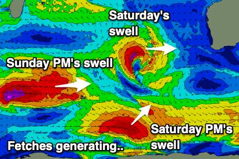
Also into the afternoon our stronger SW groundswell from a stronger but more distant polar low should arrive, offering similar sized surf but with more power.
Unfortunately winds pook strong from the W/NW across the South West, moderate to fresh to the north, creating poor conditions.
Sunday should see an OK but not great window of early N/NE winds across Perth and Mandurah, strong N/NW to the south and with similar sized surf to Saturday afternoon.
The size will quickly jump though as some larger W/SW groundswell arrives, generated by a secondary mid-latitude frontal system projecting towards us over the coming days.
Building surf to 10ft+ is likely into Sunday afternoon in the South West, 3-4ft Mandurah and 3ft Perth but with NW winds.
We’re then due to see a third, strongest of all systems firing up west of us on Sunday and this looks to generate even larger XL swell into Monday.
EC has the low a little weaker but regardless it’ll be large with winds possibly tending variable as the swell producing low slips away to the south-east ahead of the next approaching front.
We’ll have to confirm this and the sizes on Friday.
The follow up activity will continue to generate large surf through the middle to end of the week but with onshore winds as the fronts push more across us. More on this Friday.
Comments
Pretty cool seeing all those fronts starting to align on the charts.
Hefty!!!
First proper progression of the season!
Indeed! There go's our incredible run of late May warm weather and light offshores.
The LWT returns with a vengeance....and a monster swell.
gonna be in WA from next Thursday, which looks to be building to a 7.8m swell... that might be the biggest numbers i will have ever seen irl (other than nazare)
WTF it just jumped to 8.7m!??!