Average outlook continues

Western Australian Surf Forecast by Craig Brokensha (issued Wednesday February 7th)
Best Days: Desperate surfers on the South West magnets Friday morning, the South West Wednesday and Thursday mornings next week.
Features of the Forecast (tl;dr)
- Small pulse of mid-period SW swell Fri with gusty E/NE winds ahead of mid-late PM sea breezes
- Fading swell on the weekend with E/NE-NE tending fresh N/NE then NW winds Sat, S/SE tending S/SW
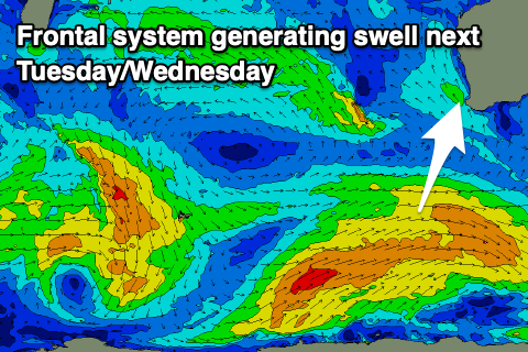
- Moderate sized, mid-period S/SW swell building Tue with strong S/SE-S winds, peaking Wed AM with gusty SE tending S/SE winds
- Easing swell Thu with E/SE winds
Recap
Great conditions yesterday morning but with a small, fading swell from the 3ft range in the South West, tiny to the north. Today is even smaller with a stronger offshore wind.
This week and weekend (Feb 8 - 11)
The current poor outlook is due to continue into the end of the weekend.
Tomorrow morning looks to be a low point in swell but with clean conditions again and relatively weak afternoon sea breezes.
Our small pulse of mid-period SW swell for Friday is just that, generated by a weak, south-east tracking tropical depression with no healthy fetch aimed towards us. A small bump to 2-3ft may be seen across the South West magnets under gusty E/NE winds that will go variable ahead of mid-late afternoon sea breezes.
Saturday looks smaller and slower with waves to 2ft to maybe 3ft in the South West, fading through Sunday. Winds will be best Saturday morning and E/NE-NE in the morning, freshening from N/NE and then NW into the afternoon as a trough moves across us. In the wake of the trough, less favourable S/SE tending S/SW winds are due on Sunday so it'll be average.
Next week looks a little more active as a couple of stronger polar storms fire up in our southern swell window, though a little to late and east to generate any major surf.
The first system will generate a broad fetch of strong W/SW winds through our southern swell window, with a moderate sized, mid-period S/SW swell due to arrive later Tuesday but peak Wednesday to 4-5ft in the South West, tiny to the north.
Winds as the swell builds look unfavourable and S/SE, with Wednesday offering gusty SE tending strong S winds.
Thursday looks smaller but nice and clean again with an E/SE offshore ahead of sea breezes.
A secondary pulse of possible larger SW groundswell is on the cards for Friday but the models diverge on this source. More on this Friday.
Comments
Thanks Craig. Any long range forecasts for the Indian ocean basin for Autumn?