Smaller surf with dicey winds

Western Australian Surf Forecast by Craig Brokensha (issued Wednesday January 31st)
Best Days: No great days
Features of the Forecast (tl;dr)
- Easing surf tomorrow, slowed by a reinforcing mid-period SW swell, smaller Fri
- Fresh S/SE-SE tending SW winds tomorrow, moderate S/SE Fri AM ahead of sea breezes
- Moderate sized mid-period SW swell for late Fri, peaking Sat AM
- Strong S tending S/SW winds Sat, similar Sun (S/SE early to the north Sun)
- Easing surf Mon with S/SE tending SW winds
- Small, clean waves Tue with E/SE tending S/SW winds
Recap
Great conditions yesterday morning with a temporary drop in swell across the South West to 4-5ft, before things started to build again into the afternoon but with sea breezes. Mandurah saw 2ft sets, with inconsistent 2ft waves across Perth, and this morning provided some good, clean conditions as the swell held in nicely.
Margs was in the 5-6ft range with 2ft surf continuing across Mandurah, 1-2ft in Perth.

Good sized sets still in the mix this AM
This week and weekend (Feb 1 - 4)
The current swell has peaked and will ease into this afternoon, further tomorrow across the state.
The trend will be slowed slightly by the arrival of some mid-period SW swell tomorrow, generated by a strengthening frontal system that pushed past our south-west yesterday.
Surf to 4ft is due across the South West, tiny and to 1-1.5ft to the north, then easing Friday.
Winds will be less favourable but doable tomorrow and S/SE-SE in the morning across the South West, E/SE to the north, not great Friday and more S/SE in the morning though light in nature.
Moving into the weekend, strong S-S/SW winds will move in as a weak front pushes under our south coast, squeezing a strong high to our west.
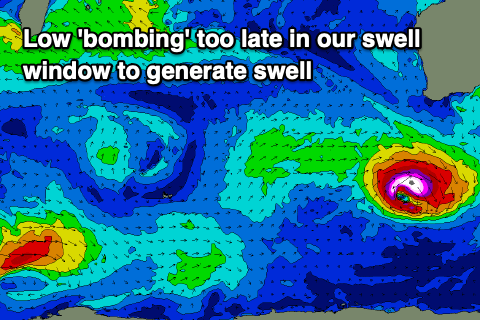
This will spoil a new mid-period SW swell that's due to fill in later Friday, peaking Saturday morning, generated by a broad fetch of strong W/SW winds to the north-east of the Heard Island yesterday.
The additional S/SW groundswell due from a 'bombing' low forming late in our swell window looks minimal now, with the low not reaching any real strength until east of our swell window.
Size wise, Saturday morning should come in at 4-5ft+ across the South West, easing through the day with 1-1.5ft sets to the north. As touched on above, strong S tending S/SW winds will create poor conditions on Saturday, with similar winds due Sunday as the swell eases in the South West, more S/SE to the north.
The improvement in local winds looks slow next week with weaker S/SE breezes due Monday morning, offshore Tuesday from the E/SE but with small, fading levels of background S/SW swell.
Longer term the outlook remains wishy-washy with tropical developments in the Indian Ocean expected to drift south-east and meet with frontal systems, but only late in our swell window.
So all in all I hope you got a couple in the last two days.