Moderate swell pulses continue with tricky winds

Western Australian Surf Forecast by Craig Brokensha (issued Monday January 29th)
Best Days: Tomorrow ahead of sea breezes, Wednesday and Thursday mornings
Features of the Forecast (tl;dr)
- Reinforcing moderate sized, mid-period SW swell for tomorrow PM, easing from a similar sized Wed AM
- Fresh SE tending E/SE winds tomorrow ahead of strong sea breezes, moderate S/SE tending strong S/SW-SW winds Wed
- Small-mod sized, reinforcing swell Thu with S/SE-SE tending strong S/SW-SW winds
- Smaller Fri with early S/SE tending SW winds
- Mix of mid-period SW swell Sat with building S/SW groundswell into the PM
- Strong S/SE winds Sat and Sun AM
Recap
Fun surf across the South West on Saturday morning with an easing 3-4ft of swell but with great conditions. Perth and Mandurah were tiny.
Yesterday was a lay day across all locations with smaller surf and less favourable winds.
Today some new mid-period SW swell has filled in with a lift in size to 4-5ft across the South West, 1-2ft in Mandurah and 1-1.5ft across Perth with better, cross-offshore winds.
This week and weekend (Jan 30 – Feb 4)
Today's bump in mid-period SW swell is due to be followed by a secondary pulse of better swell tomorrow, generated by back to back fetches of strong W/SW winds through our south-western swell window over the weekend and today.
The secondary pulse should fill in during the day tomorrow, peaking into the afternoon to 5-6ft in the South West, 1-2ft across Perth and Mandurah, easing back from a similar size Wednesday morning.
Conditions look good and improving tomorrow with a fresh SE tending E/SE breeze ahead of strong afternoon S/SW-SW winds.
Wednesday looks a little less favourable with weaker S/SE-SE winds, shifting strong S/SW-SW earlier rather than later.
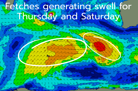
Similar winds are due into Thursday but with smaller surf, though the easing trend will be slowed by a small-moderate sized reinforcing mid-period SW swell generated by a strengthening front pushing in tomorrow to our south-west.
Friday looks to be a lay day with smaller surf and early S/SE winds that will quickly strengthen from the S/SW.
Into the weekend we've got a mix of mid-period SW swell and S/SW groundswell due Saturday, with the former generated by a broad but short-lived fetch of W/SW winds, north-east of the Heard Island region tomorrow.
The tricky, S/SW groundswell will be produced as the remnants of Tropical Cyclone Anggrek drifts south-east through the Indian Ocean, combining with a cold air injection on Thursday resulting in the rapid intensification of the low.
The low looks to deepen late in our swell window, with a fetch of severe-gale to storm-force W/SW winds only just generating a small spike of swell for Saturday afternoon.
Size wise, the mid-period energy looks to come in at 4-5ft+ across the South West, 1-1.5ft to the north on Saturday with the S/SW groundswell not likely to get above that. The southern coast should see larger surf though.
Unfortunately winds look unfavourable for this swell as strong S/SE-S/SW winds kick in on Saturday, a touch weaker but still S/SE into Sunday with easing surf.
Into next week, the swell will ease as winds improve Monday/Tuesday though we'll have a closer look at this on Wednesday.