Slower period with workable windows

Western Australian Surf Forecast by Craig Brokensha (issued Friday January 26th)
Best Days: South West swell magnets for the keen tomorrow morning, South West for the keen Monday morning but more so Tuesday morning
Features of the Forecast (tl;dr)
- Easing swell Sat with moderate E/SE-E winds ahead of sea breezes
- Small pulse of SW groundswell Sun with SW winds
- Small-mod sized mid-period SW swell for Mon with E/SE-SE tending strong S/SW-SW winds
- Slightly stronger moderate sized mid-period SW swell for Tue, peaking in the PM with gusty SE tending E/SE winds ahead of sea breezes
- Easing swell Wed with S/SE tending SW winds
Recap
Yesterday's large SW groundswell came in right on cue with 8-10ft sets in the South West, building surf to 3ft across Mandurah and 2-3ft in Perth through the afternoon. Conditions were cleaner than expected across the South West in the morning ahead of strong sea breezes, while Mandurah remained good in protected spots until mid-afternoon.
This morning the surf is cleaner and on the ease but still a solid 6ft+ across the South West magnets, 2-3ft in Mandurah and 2ft across Perth.

Good, clean surf this AM
This weekend and next week (Jan 27 – Feb 2)
The current swell will ease off rapidly into tomorrow with tiny surf due across Perth and Mandurah, best in the South West but only 3ft+ or so.
Winds tomorrow will be great, moderate from the E/SE, tending E through the day ahead of sea breezes.
Our small pulse of SW groundswell for Sunday is on track, generated by a very short-lived fetch of W/SW gales that were dipping south-east ahead of a frontal system in the Heard Island region tomorrow.
It'll only provide a small bump in size, building to 4ft through the day and winds now look onhsore from the SW as a front clips the state.
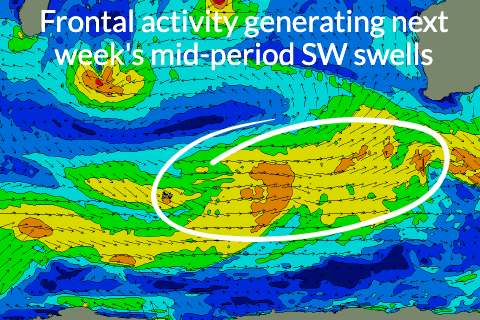
This front now looks to arrive earlier than forecast on Wednesday and with it, a pulse of mid-period SW swell for Monday, followed by a stronger increase on Tuesday.
A broadening fetch of strong W/SW winds projecting towards us should generate these pulses of swell, with Monday's coming in at 3-5ft across the South West, 1-1.5ft to the north while a secondary pulse of swell for Tuesday should reach 5-6ft across the South West magnets into the afternoon with small 1-2ft sets to the north, easing back slowly through Wednesday.
Winds should shift back E/SE on Monday morning creating clean conditions ahead of strong S/SW-SW sea breezes, SE tending E/SE on Tuesday morning.
Winds on Wednesday might tend a little more S/SE in direction but we'll review this Monday.
Similar S/SE winds are likely into Thursday and Friday with smaller pulses of reinforcing energy. Have a great weekend!