Improving, easing XL surf

Western Australian Surf Forecast by Craig Brokensha (issued Monday October 2nd)
Best Days: Tomorrow morning Perth and Mandurah (protected spots South West), Wednesday morning all locations, Thursday ahead of sea breezes all locations, Friday ahead of sea breezes all locations, Saturday and Sunday mornings in the South West
Features of the Forecast (tl;dr)
- XL groundswell peaking early tomorrow, easing gradually, large but becoming smaller Wed
- Strong but rapidly easing S/SW winds in the South West tomorrow, S/SE in the AM to the north
- Light E-E/NE winds Wed AM (E/SE to the north) ahead of sea breezes
- Large building S/SW groundswell Thu with moderate E/SE winds ahead of sea breezes
- Steadily easing S/SW groundswell Fri with E/SE winds ahead of mid-PM sea breezes
- Reinforcing moderate sized SE groundswell Sun with NE tending NW winds
Recap
Poor surf all weekend with easing onshore winds through Saturday, strengthening through yesterday as a vigorous frontal progression started to move in.
Today we've got strong to gale-force onshore winds, rain and an XL building swell across the South West with stormy waves developing across the metro locations as the progression pushes up and across us.
This week and weekend (Oct 3 - 8)
Today's strong and shifting winds are thanks to the slow moving frontal progression linked to our coming XL groundswell moving in. We're due to see winds shift more W/SW-SW while easing a touch later today, abating more noticeably tomorrow while shifting S/SW.
Winds will be strong early in the South West but back off to moderate through the afternoon while Perth and Mandurah should see S/SE breezes through the morning.
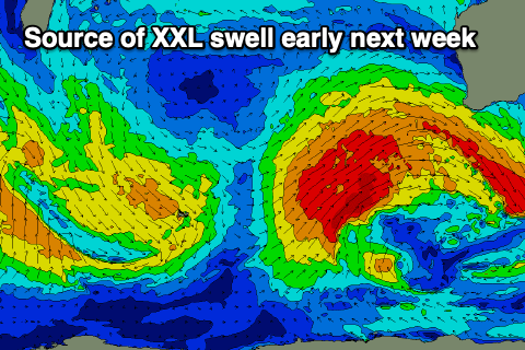
Swell wise the groundswell energy is due to fill in overnight tonight proper and peak early tomorrow morning, easing steadily thereafter.
The South West should be around 15ft tomorrow morning on the exposed reefs and bombies, with 4-5ft+ waves across Mandurah and 3-4ft surf in Perth, all easing through the day.
Wednesday looks cleaner across the South West but still likely lumpy under a light E/NE offshore, E/SE to the north ahead of afternoon sea breezes. The swell will be large but easing with 8ft sets early across the South West, 2-3ft Mandurah and 2ft Perth.
Thursday should be clean again in the morning with an E/SE offshore wind and we'll see a very temporary low point in swell ahead of some new, large S/SW groundswell building rapidly through the day.
The source is a 'bombing' low forming around the Heard Island region today, with the rapid drop in central pressure resulting in a fetch of gale to severe-gale NW winds to be followed by severe-gale to storm-force W'ly winds on the polar shelf, south-southwest of us.
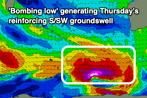
The groundswell looks beefy and should build to 8-10ft on the South West magnets into the afternoon, 2-3ft across Mandurah and 2ft in Perth but with those sea breezes.
Friday will see the swell easing back in size from 6ft to possibly 8ft early in the South West 2-3ft Mandurah and 2ft Perth along with E/SE offshore winds, holding ahead of mid-afternoon sea breezes.
Saturday looks smaller and fun across the South West with morning offshore winds, while a reinforcing SW groundswell on Sunday should bump wave heights back up though with deteriorating conditions thanks to a trough which will bring NE tending NW winds.
Next week looks small and windy so with the dicey outlook, make the most of the coming days and improving conditions with the significant swell sources.