Fun surf to end the week, tricky into the weekend

Western Australia Surf Forecast by Craig Brokensha (issued Wednesday May 24th)
Best Days: Tomorrow, Friday in the South West and Mandurah, Saturday morning in the South West, Sunday afternoon Perth and Mandurah, Monday morning Perth and Mandurah
Features of the Forecast (tl;dr)
- Mod-large mid-period S/SW swell peaking tomorrow AM with E/SE-SE winds, tending SE into the PM
- Easing swell Fri with E tending variable winds
- Smaller Sat with morning offshore winds, shifting W
- Large S'ly groundswell Sun, with a small-mod W/SW groundswell building into the PM, easing Mon
- Mod-fresh W winds in the South West Sun/Mon, NE tending NW to the north Sun/Mon
- Easing surf Tue with strengthening NW winds
Recap
Poor, deteriorating surf across all locations yesterday while today a strong mid-latitude frontal system has brought with it poor, strong S/SW winds. Mandurah saw more favourable S/SE winds and a lumpy 1-2ft of swell for the keen. Winds have also gone S/SE across Perth now but with a rapid drop in swell.
This week and weekend (May 23 - 28)
We've got much better surf due over the coming days as the mid-latitude frontal system linked to the recent poor winds and weather generates a moderate-large mid-period S/SW swell for tomorrow along with improving winds as it clears to the east.
The South West looks to now reach 8ft tomorrow morning before easing through the day with 2-3ft sets across Mandurah and 2ft waves in Perth.
Winds are due to swing E/SE-SE tomorrow morning across all locations, favouring most spots and only tending SE into the afternoon.
Friday will see straighter E'ly winds, tending variable into the afternoon along with a steady drop in size, back from 5-6ft in the South West, 1-2ft in Mandurah and 1-1.5ft across Perth.
Saturday looks smaller and early light offshore winds will create clean conditions ahead of an afternoon W/SW change which unfortunately looks to linger out of the W through Sunday.
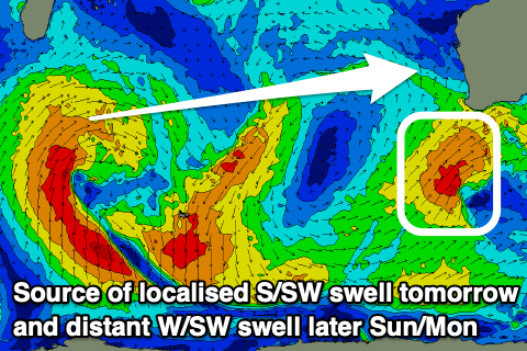
This will be as a strong new S/SW groundswell arrives, generated by a significant polar storm firing up to the south of the country. It'll be late in our southern swell window but we should still see a fetch of severe-gale SW winds generated, producing decent size on the south magnets in the South West.

Surf to 8ft is due across most south swell magnets but very inconsistent thanks to the direction (bigger across exposed south facing coasts). There might be the rare bigger one and to the north, it'll hardly make a dent. Small, inconsistent 1-2ft sets may be seen at Mandurah with 1-1.5ft waves in Perth. Winds will be better across these locations and light offshore from the NE, tending NW through the day but without any strength.
Also in the mix for the metro locations on Sunday afternoon and Monday morning will be an inconsistent but fun W/SW groundswell.
This is being generated by a slow moving mid-latitude low that's formed south of Madagascar, producing a fetch of strong to near gale-force W/SW winds. The low will dissipate tomorrow leaving the swell to decay while pushing east. It'll be inconsistent but surf to 2ft is due Sunday afternoon and Monday morning in Perth and Mandurah.
Monday looks similar wind wise, onshore from the W/NW in the South West with easing 6ft sets and NE to the north with the easing W/SW swell.
Longer term there's nothing too major on the cards for the region but check back here on Friday for the latest.