Good swell tomorrow with average winds, better opportunities next week

Western Australia Surf Forecast by Craig Brokensha (issued Monday January 23rd)
Best Days: Protected spots tomorrow and Wednesday morning in the South West, Thursday morning in the South West for the keen, Monday morning, Tuesday morning
Features of the Forecast (tl;dr)
- Moderate sized + SW groundswell tomorrow with strong S/SE tending S/SW winds
- Easing swell Wed with strong S/SE tending S/SW winds
- Smaller Thu with fresh E/SE-SE tending S/SW winds
- Small Fri with strong S/SW-SW winds
- Small mid-period SW swell for Sat/Sun with gusty SE morning winds, S/SW into the PM
- Mod-large S/SW groundswell building Mon with fresh SE tending S/SW winds
- Easing surf Tue with gusty SE tending SW winds
- Reinforcing surf for Tue/Wed
Recap
Clean conditions each morning but with small to tiny surf, biggest Saturday morning but only to 2ft or so in the South West.
This morning we've got similar small to tiny surf but a new SW groundswell should build into this afternoon but with sea breezes.
This week and weekend (Jan 24 - 29)
The coming week revolves around this afternoon's building SW groundswell with a peak due tomorrow. It was generated by a strong and healthy low with a fetch of W/SW gales produced from the south-southeast of South Africa to the Heard Island region.
Good 6ft sets are due across the South West 2ft in Mandurah and 1.5ft across Perth along with less than ideal, strong S/SE tending S/SW winds in the wake of a trough sliding in from the south-west this evening.
Protected spots will be the best through the morning so target those locations but expect a little less size.
Winds will unfortunately remain strong from the S/SE on Wednesday as the swell starts to drop, with easing 4-5ft sets in the South West, tiny to the north.
Thursday will become cleaner with a weaker E/SE-SE offshore wind but smaller, fading swell from 3ft to occasionally 4ft on the South West magnets, tiny to the north.
Friday looks smaller and a trough will bring strong S/SW winds, creating poor conditions.
Winds should improve on the weekend, shifting SE on Saturday morning before strengthening Sunday but swell wise we're only looking at small levels of mid-period swell.
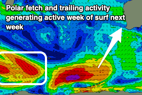
Of greater significant is a strong polar low generating a fetch of W/SW-SW gales through our south-western and then southern swell windows late week and into the weekend
This should generate a moderate sized + S/SW groundswell for Monday with building sets to 6ft+ due across the South West, 2ft in Mandurah and 1-2ft across Perth along with fresh morning SE winds.
Healthy trailing frontal activity is likely to keep wave heights up through Tuesday and Wednesday as winds slowly improve but we'll take a closer look at this in the next update.