Windy weekend with fading surf

Western Australia Surf Forecast by Craig Brokensha (issued Friday September 2nd)
Best Days: Today, tomorrow South West magnets, protected spots Tuesday morning Perth and Mandurah, Thursday morning
Features of the Forecast (tl;dr)
- Easing SW swell Fri with strong E tending slightly weaker E/NE winds
- Easing surf on the weekend with strong E/NE tending NE winds Sat, gusty NE Sun then easing and tending N
- Strong S/SW winds Mon
- Building W/SW groundswell later Mon, peaking Tue AM with fresh S/SW tending stronger SW winds (S/SE early Perth and Mandurah)
- Easing W/SW groundswell Wed with SW winds
- Reinforcing moderate sized SW swell Thu AM with variable morning winds
Recap
Pumping surf across all regions yesterday with the arrival of a strong SW groundswell during the day, pulsing to a strong but inconsistent 8ft in the South West, 3ft across Mandurah and 2ft in Perth.
Today the swell has eased and conditions are still great but windy in the South West with easing 5-6ft sets, 2-3ft early in Mandurah and 1-1.5ft across Perth. Winds will ease a touch this afternoon while tending E/NE, so make the most of the current swell before it fades over the weekend.

Flawless yesterday afternoon
This weekend and next week (Sep 3 - 9)
Get stuck in this afternoon for a surf as the weekend is looking smaller and slower across all regions, becoming tiny across the metro locations and best across the magnets in the South West.
A low forming north-northwest of us will bring strong E/NE tending NE winds tomorrow with easing 3ft surf early across the South West, 1-1.5ft Mandurah and 1ft Perth.
Sunday will be smaller again along with fresh but easing N/NE tending N winds as the low weakens and starts to move south-east.
We'll see the low push east across us in the form of a weaker trough early Monday, bringing strong S/SW winds to all locations along with a morning low point in swell.
The low point will be short-lived, with a large, long-period W/SW groundswell set to arrive during the day, building into the afternoon though peaking through Tuesday
On Wednesday the swell generating system looked a little bit suspect, but the models have resolved the storm which has formed north-west of the Heard Island region.
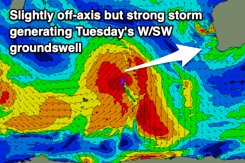 A healthy fetch of slightly off-axis gale to severe-gale W/SW winds are forecast to be generated today and tomorrow morning before weakening on approach to us.
Sets to 6-8ft are due across Margs on Tuesday with 2-3ft sets in Mandurah and Perth but with lingering S/SW winds in the South West, strengthening from the SW into the afternoon. Early S/SE winds are due in Perth and Mandurah which will favour protected spots.
The strengthening and swing in winds to the SW during Tuesday afternoon will be linked to a weak low forming off our South Coast, directing SW breezes up and into us. These may persist Wednesday as the low remains semi-stationary and with a drop in swell from Tuesday.
Variable winds will hopefully be seen on Thursday and a new pulse of reinforcing mid-period SW swell is expected to peak in the morning, generated by a fetch of strong to gale-force W/NW winds expanding north-east towards us on the weekend.
The South West should see 6ft sets, 2ft in Mandurah and 1-1.5ft across Perth, easing Friday as winds go back onshore with a trough.
Longer term there's nothing too major on the cards, so again make the most of today.