Great end to the week

Western Australia Surf Forecast by Craig Brokensha (issued Wednesday August 31st)
Best Days: Thursday, Friday, Saturday morning in the South West, protected spots next Tuesday
Features of the Forecast (tl;dr)
- Large SW groundswell tomorrow, easing later with fresh E winds, tending variable most spots and S/SE later in the South West
- Easing SW swell Fri with strong E tending E/NE winds, easing a touch but then back to a strong E/SE'ly later
- Easing surf on the weekend with strong E/NE winds Sat, gusty NE Sun then easing
- Strong S/SW winds Mon
- Building W/SW groundswell later Mon, peaking Tue AM with strong S/SE-S winds
Recap
The run of great surf continued into yesterday morning with clean, easing 6-8ft sets across Margs, 2-3ft in Mandurah and 2ft+ across Perth. A reinforcing pulse of SW swell due into the afternoon and this morning looks to have come in sightly under expectations in the South West but on size in Perth and Mandurah. A trough brought less favourable winds to the South West this morning, cleaner to the north.
This week and next (Sep 1 - 9)
While today was a little off across the South West, tomorrow and Friday look much cleaner as a high moves in from the west, swinging winds E'ly tomorrow morning, variable into the afternoon but S/SE-SE late in the South West.
 Stronger E'ly winds are due Friday, easing and tending E/NE before strengthening later from the E/SE again
Swell wise, we've got a good new SW groundswell due tomorrow, generated by a healthy, persistent polar frontal system that originated from the Heard Island region and projected north-east towards us. The front is now passing south of us, linked to today's shift in winds and we should see the swell peaking tomorrow in the 8ft range across the South West, 2-3ft in Mandurah and 2ft across Perth.
The swell looks to ease into the afternoon with Friday dropping back from the 6ft range across the South West on the sets, 2ft+ in Mandurah and 1-2ft in Perth.
Looking at the weekend and the surf will continue to ease in size as winds remain strong and E/NE owing to a low forming to our north-northwest. Winds are due to swing fresh NE on Sunday as the low moves further east but weakens.
The remnants of the low are expected to move across us Monday bringing a fresh to strong S/SW change as the swell reaches a low point.
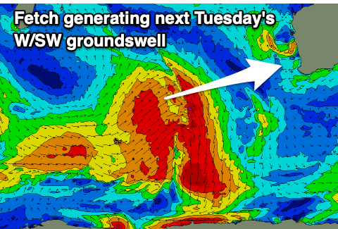 Into the afternoon, a new W/SW groundswell should arrive, generated by a mid-latitude low being absorbed into the westerly storm track north-east of Heard Island, with a fetch of gale to severe-gale W/SW-SW winds due to be generated through our swell window.
While relatively short-lived, the intensity and eastward projection of the low should produce a moderate to large sized W/SW groundswell for later Monday and more so Tuesday.
Good 6ft to possibly 8ft sets are due in the South West, 2-3ft in Mandurah and 2ft+ Perth but with strong S/SE-S winds in the wake of Monday's change. Wednesday looks to be a little cleaner as the swell eases but we'll have look at this in more detail Friday as the models diverge a little.