Good surf next week

Western Australia Surf Forecast by Craig Brokensha (issued Friday August 19th)
Best Days: Keen surfers Margs tomorrow AM, Perth and Mandurah tomorrow AM, later Sun in the South West, Monday through Thursday in the South West, Perth and Mandurah Monday, Tuesday and Thursday
Features of the Forecast (tl;dr)
- Moderate sized, mid-period SW swell for Sat with variable tending W winds in the South West, E/NE tending NW Perth and Mandurah
- Easing surf Sun with S/SW tending strong S/SE winds in the South West, S/SE tending S/SW further north
- Mid-period SW swell building later Sun
- Mod-large SW groundswell Mon AM, easing with strong SE tending E/SE winds, easing Tue with strong but easing E tending E/NE winds
- Smaller Wed with E/NE tending NE winds
- New mid-period SW swell Thu with E/NE tending NE winds
Recap
Great waves across Perth and Mandurah yesterday morning with 3ft of W'ly swell and great conditions through the morning, decent into the afternoon in Perth, bumpy in Mandurah. Margs was average and onshore without any major size.
Today conditions are less than ideal with a drop in size and variable winds across Perth and Mandurah with average onshore surf in Margs.

Solid surf yesterday AM
This week and weekend (Aug 20 - 26)
Moving into the weekend and winds are looking variable across the South West tomorrow morning but with no true offshore or strength to any that develops we'll see a bit of lump across the South West. Perth and Mandurah should be cleaner with E/NE offshore winds and a new, reinforcing SW swell is expected, generated by a fetch of strong W/NW tending W winds swinging in from the west-southwest the last two days.
 Sets to 6ft are due across the South West, 2ft+ in Mandurah and 2ft in Perth.
This swell will ease into Sunday and unfortunately S/SW winds will create average conditions in the South West, improving across protected spots into the afternoon as winds shift S/SE and strengthen. There'll be no size though. Looking at Perth and Mandurah, morning SE winds are due but with easing 1-2ft sets.
Next week will provide better opportunities for a surf in the South West as a high moving in Sunday afternoon continues to push further east, bringing strong SE winds, shifting E/SE through the day Monday.
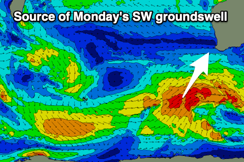
Swell wise a good new SW groundswell is due generated by a slow moving and slightly fractured polar low that's currently just east of the Heard Island region. The low will be strongest to our south-west and we should see a late pulse of size Sunday ahead of a peak Monday to 6-8ft across the South West, 2-3ft in Mandurah and 2ft+ in Perth, easing through the day.
 Winds will be strong from the E on Tuesday morning, easing and tending E/NE as the swell eases back in size from 4-6ft in the South West, 2ft in Mandurah and 1-2ft Perth.
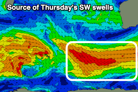
Wednesday looks smaller with E/NE-NE winds, similar Thursday but with a new pulse of mid-period SW swell filling in.
The source of this and an additional swell later afternoon will be a progression of polar fronts generating a broad fetch of strong to near gale-force W/NW winds. Size wise the South West will benefit the most with surf to 4-5ft+, slow and 1-2ft max in Mandurah if that and tiny in Perth.
Following this we're looking at a new SW groundswell for next weekend but with dicey winds. We'll have a closer look at this Monday. Have a great weekend!