Improving conditions from tomorrow

Western Australia Surf Forecast by Craig Brokensha (issued Wednesday August 17th)
Best Days: Later today Perth and Mandurah, Perth and Mandurah tomorrow and Friday, all locations Saturday, Perth and Mandurah Sunday morning, all locations Monday and Tuesday
Features of the Forecast (tl;dr)
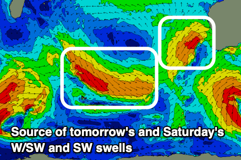
- Moderate-large W/SW swell for tomorrow (more so PM for Margs)
- Increasing W/SW winds in the South West tomorrow, morning E/NE-NE tending NW Perth and Mandurah
- Easing W/SW swell Fri with W/SW winds in the South West, E/NE Perth and Mandurah
- Moderate sized, mid-period SW swell for Sat with variable E/NE tending NW winds
- Easing surf Sun with W/SW winds in Margs, SE in Perth and Mandurah
- Mod-large SW groundswell Mon with strong SE winds, easing Tue with strong but easing E/SE winds
Recap
Terrible surf across all locations as expected yesterday with a strong mid-latitude front pushing into us bringing strong onshore winds and some localised, poor swell.
Today a trough was expected to bring improving conditions to the metro regions but it's been delayed. We should still see winds ease off considerably and tend more variable this afternoon across all locations so don't write it off completely for the day.
This week and weekend (Aug 18 - 21)
Looking at tomorrow and the current localised swell is due to ease in size ahead of some new mid-period W/SW energy due to arrive into the afternoon across all locations. In saying this Perth and Mandurah may see an earlier increase in size due to the final stages of the mid-latitude front linked to the swell pushing north and across their regions this afternoon and evening.
 Perth and Mandurah should reach 3ft with building sets to 6-8ft in the South West.
Locally Perth and Mandurah should be decent with light E/NE-NE breezes, shifting more N'ly through the day and then NW into the afternoon.
Pre-dawn variable winds are due in the South West, though tending W/SW at dawn and strengthening through the day. Not ideal at all.
Onshore W/SW winds are due to linger into Friday across the South West as the swell eases, clean again in Perth and Mandurah through the morning with variable E/NE breezes. The surf will be easing back from 2ft to possibly 3ft on the sets.
As touched on in Monday's notes, lighter winds and more favourable conditions are due to finally develop across the South West from this weekend (apart from Sunday) as high pressure starts to edge in from the west.
We should see variable E/NE-NE winds on Saturday morning and a new pulse of mid-period SW swell, generated by a fetch of strong W/NW winds swinging in from the west today and tomorrow.
There's likely to be some new size into Friday afternoon but Saturday morning should reveal 6ft surf across the South West with those better winds. Mandurah looks to be around 2ft+ with 2ft sets in Perth.
Sunday looks dicey as winds shift back to the W/SW across Margs with a weak trough. Perth and Mandurah should see morning SE breezes and easing surf.
Moving into next week and a new SW groundswell is due to peak during the morning, generated by a polar low that's currently forming south-west of South Africa.
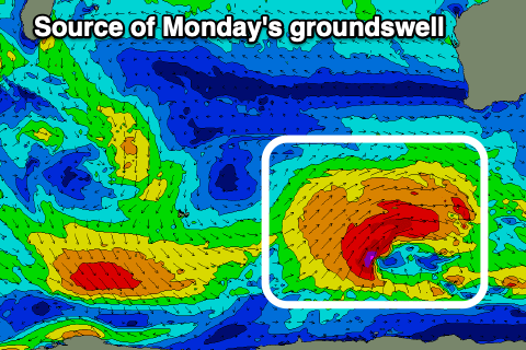 This low will produce a continuous fetch of W/SW gales while projecting east, weakening temporarily east of the Heard Island region before strengthening again south-west of us.
The swell will be mixed with some mid-period energy due to arrive into the afternoon Sunday, ahead of the less consistent groundswell Monday morning to 6-8ft in the South West, 2-3ft across Mandurah and 2ft in Perth.
A strong high moving in from the west will see winds swing to the SE but become strong on Monday morning, holding all day. Winds should swing more E/SE on Tuesday, strong in the morning and then variable into the afternoon with smaller, easing surf.
Longer term, strong polar fronts skirting the shelf look to generate fun pulses of reinforcing SW swell through next week along with favourable winds, tending more northerly later week. More on this Friday though.