Fading surf with a fun swell for Sun/Mon

Western Australia Surf Forecast by Craig Brokensha (issued Wednesday March 30th)
Best Days: Exposed breaks in the South West tomorrow for the keen, protected spots Sunday and Monday, exposed breaks Tuesday morning in the South West
Features of the Forecast (tl;dr)
- Fading S/SW swell tomorrow with strong, though abating E/NE winds
- Tiny swell Fri and Sat
- Moderate sized + mid-period W/SW swell for Sun, peaking into the PM, easing Sun
- Strong S/SE winds Sun, fresh S/SE-SE Mon AM
- Easing surf Tue with morning E/NE winds
Recap
Clean conditions with a slight bump in swell across the South West yesterday and sets to 3-4ft, tiny to flat in Perth and Mandurah while our slightly downgraded S/SW groundswell for this morning looks to have come in even smaller than expected.
The South West was a slow 4-5ft+ on the sets early this morning, since easing back to 3-5ft while Mandurah was tiny but built to 1.5ft this afternoon. Conditions are still clean but overall a bit underwhelming.
This week and weekend (Mar 31 – Apr 3)
Seeing the performance and size of the swell across the South West today, and with the swell due to ease steadily into this afternoon and evening, tomorrow isn't expected to offer much with leftover 3ft sets across the swell magnets. Perth and Mandurah will remain tiny.
 It'll be windy again with strong E/NE breezes tomorrow morning, tending lighter and more variable into the afternoon but with small levels of fading surf.
Friday and Saturday will be lay days as the swell bottoms out, with some new, mid-period W/SW swell due to Sunday and Monday.
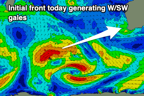
This swell is looking a little better now with the frontal system linked to it currently developing north of the Heard Island region with a fetch of W/SW gales projecting north-east. This will weaken tomorrow but a secondary intensification will produce an additional fetch of strong W/SW winds through Friday and Saturday.
 We'll see a mix of periods and swells building Sunday, reaching 5-6ft across the South West into the afternoon and 2ft sets in Mandurah and Perth, easing back slowly from 4-6ft and 2ft respectively Monday.
A trough will bring a change early Sunday with strengthening S/SE winds due through the day, leaving protected spots with the best conditions, a touch cleaner Monday with fresh S/SE-SE morning winds. Tuesday will see better E/NE morning winds but the swell will be small and fading.
Into the end of the week a mix of mid-period SW swells are due but winds look initially dicey as the frontal progression linked to it pushes up and into us. At this stage it looks to be only moderate to possibly large in size, but check back here Friday for more details.