Slow start to winter

Western Australia Surf Forecast by Craig Brokensha (issued Monday May 31st)
Best Days: Tomorrow morning all coasts, Wednesday in the South West, Thursday in the South West, Perth and Mandurah Sunday morning
Features of the Forecast (tl;dr)
- Inconsistent mid-period SW swell pulse for tomorrow with light morning offshore winds, easing Wed with variable offshore winds ahead of weak sea breezes
- Secondary, slightly smaller mid-period SW swell Thu with E/NE tending NW winds, easing Fri with fresh N/NW winds (N/NE early to the north)
- Moderate sized mid-period W/SW swell building Sat, peaking Sun with onshore winds (light E/SE Perth and Mandurah Sun AM)
Recap
Large 8-10ft surf into Saturday with fresh onshore winds across the South West that abated a little through the day, better in protected spots yesterday's but easing from 6-8ft or so.
Mandurah was a good 3-4ft with bumpy, workable conditions for the keen, back to 2-3ft yesterday and still a bit all over the place. Perth saw fun, lumpy waves to 3ft on Saturday, back to 2-3ft yesterday.
Today we've got a little less size and with less than ideal winds across the South West, better in Perth and Mandurah this morning.
This week and weekend (Jun 1 - 6)
The coming period isn't anything too special at all but we'll see some fun windows of clean waves across the South West.
The current swell is due to ease further into tomorrow, but a new mid-period SW swell should fill in overnight, steadying wave heights around 4-5ft+ in the South West tomorrow, 1-2ft further north.
This swell was generated by a short-lived polar front firing up east of Heard Island, generating a burst of W/SW gales Friday afternoon and Saturday.
Winds look like and SE-E/SE across the South West tomorrow morning, more S/SE towards Cape Leeuwin, E'ly in Perth and Mandurah ahead of sea breezes.
 A temporary drop in size is due Wednesday morning and conditions look great with variable offshore winds across all locations ahead of weak sea breezes, similar Thursday morning but with winds tending E/NE ahead of light NW sea breezes.
Later Wednesday but more so Thursday a new, mid-period SW swell is due across the state, coming in slightly under the size of tomorrow's swell. The source of this swell was pre-frontal W/NW gales moving through our swell window yesterday, weakening today with 4-5ft sets due across the South West magnets, tiny further north.
Winds will take a northerly bias as the swell eases into Friday, fresh from the N/NW across the South West, N/NE tending N/NW further north but with the tiny swell.
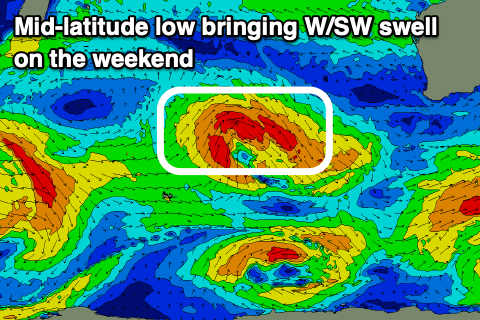
Into the weekend some new mid-period W/SW swell is due to fill in, but size wise there's nothing too major on the cards. The source of the swell will be a mid-latitude low pushing in slowly east over the coming days, generating strong to near gale-force W/NW winds.
There'll also be some SW energy in the water from the backside of the low but with average S'ly winds Saturday as the swell builds, options will be limited. Sunday looks better across Perth and Mandurah but not ideal to the south with lingering S winds and surf to 5-6ft in the South West, 2-3ft in Mandurah and 2ft across Perth.
The surf should ease into Monday but this will be the pick across the South West with offshore winds.
Longer term there's still nothing of any real interest with possible increasing frontal activity late next week but with onshore winds. More on this Wednesday though.