Good run of windy offshores and swell

Western Australia Surf Forecast by Craig Brokensha (issued Friday January 1st)
Best Days: Every day besides Monday when the swell is at its lowest, Perth and Mandurah tomorrow afternoo, Saturday morning and Wednesday morning
Features of the Forecast (tl;dr)
- Fun, mid-period SW swell for the weekend with morning E/SE winds
- Moderate-large S/SW groundswell for Wednesday with morning E/NE winds
Recap
Happy New Year! The good, though inconsistent swell seen through Tuesday/Wednesday eased back slowly through yesterday, with clean, fun, small waves in Perth and Mandurah.
Today the swell has eased further, small in the South West with 1-2ft waves continuing across Perth and Mandurah.
This weekend and next week (Jan 2 - 8)
The coming period looks fun with a couple of surf worthy swells and favourable winds.
Firstly our new mid-period SW swell for tomorrow is on track, generated by a broad though relatively weak polar frontal progression the past couple of days, and a secondary similar progression should generate a secondary slightly smaller S/SW pulse for later Monday and more so Tuesday.
Tomorrow's swell should be visible from the morning, building and reaching 4-6ft across the South West swell magnets, with it arriving early afternoon in Mandurah and Perth, kicking to 2ft and 1-2ft respectively.
Conditions tomorrow will be favourable though breezey with strong SE tending E/SE winds, easing late morning ahead of S/SE winds into the afternoon. Perth and Mandurah may remain clean all day.
 Sunday looks great with fresh, though easing E/SE winds ahead of similar winds to Saturday into the afternoon. The swell will be on the ease though and a bit smaller than Saturday afternoon.
The swell will be at a low point Monday with strong, easing morning E'ly offshore winds ahead of sea breezes.
The new S/SW swell Tuesday looks a touch smaller than Saturday's, coming in at 4-5ft across the South West magnets, tiny to the north with gusty though easing E/SE winds through the day.
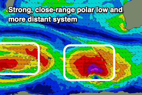
We then look at the groundswell due into the middle of the week, and this has been upgraded a little since Wednesday's outlook, with a strong polar low forecast to form in the Heard Island region Saturday evening, strengthening in our southern swell window while generating a fetch of severe-gale to storm-force W'ly winds.
A good, long-period S/SW groundswell should be generated by the low, arriving overnight Tuesday and peaking Wednesday to a great 6-8ft in the South West, 2ft+ across Mandurah and 2ft in Perth. Conditions will continue to be favourable with strong morning offshore E/NE winds, easing and tending more N'ly. Thursday looks great as the swell eases, but more on this Monday.
A secondary, more distant and weaker low looks to generate a reinforcing groundswell for next weekend, but we'll look at this in more detail Monday. Have a great weekend!