Lots of activity on the way, and increasing

Western Australia Surf Forecast by Craig Brokensha (issued Monday 6th July)
Best Days: Perth and Mandurah Wednesday morning, Thursday (protected spots South West), Friday, Saturday
Recap
A clean and fun start to the weekend though small and around 3ft or so in Margs, building through the day as winds remained favourable for selected breaks. Perth and Mandurah were tiny but clean Saturday morning, while all locations saw bumpy and deteriorating conditions yesterday as a mid-latitude low moved in.
This low is now kicking up large and stormy surf across all locations but with no quality.
This week and weekend (Jul 7 - 12)
We'll see the mid-latitude low linked to the current poor weather and surf slowly moving off to the south-east through tomorrow, but a secondary front pushing up behind it will keep onshore winds blowing across the South West until Thursday.
 All spots will be poor tomorrow with strong W/SW tending W winds, and an easing short-range swell from 3ft or so in Perth, 3ft+ across Mandurah and 8ft on the sets in the South West.
Wednesday still looks to be a low point with the surf back to 1-2ft in Mandurah, tiny in Perth and 3-5ft across the South West
Winds will remain S/SW-S across the South West, better to the north and variable E-SE.
Moving into Thursday and Friday, there's been no change to an initial and good long-period W/SW groundswell that's due to build, followed by the longer-period and reinforcing swell later Friday but more so Saturday.
The first swell has been generated by patchy though persistent and good fetches of severe-gale W/SW winds that developed south of South Africa and projected slowly east.
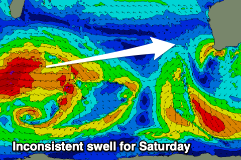
This swell should build Thursday and reach 6-8ft+ across the South West by late in the day, 2-3ft in Mandurah and 2ft+ across Perth. A slight drop in size is likely Friday morning, ahead of a late pulse of new longer-period swell, filling in properly Saturday. Now this swell will be very inconsistent, with it generated in our far, far swell window south-west of South Africa, though the remnants of it are still generating a great fetch of gale to severe-gale W/SW winds south-east of Madagascar today.
Size wise we should see the South West come in at 6-8ft+ again Saturday, 2-3ft in Mandurah and 2ft+ across Perth.
Coming back to the local winds and Thursday will be clean across Perth and Mandurah with E/SE offshores, while Margs looks a little average with S/SE tending S winds.
 Friday is much better with E'ly offshores across all locations, variable into the afternoon. On Saturday we'll see winds freshen and swing from the E/NE to NE as a strong mid-latitude frontal progression moves in from the west, spoiling Sunday with strengthening N/NE winds.
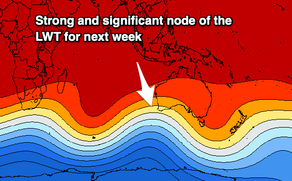
The mid-latitude frontal progression mentioned above will be quite significant, with a significant and strong node of the Long Wave Trough due to move in from the west and across us mid-late next week.
This will bring back to back, broad and very significant storms in from South Africa, across the Indian Ocean. Large to extra-large long-period swells are on the cards but also with onshore winds through most of next week. We'll have a closer look at this Wednesday though.