XXL swell developing

Western Australia Surf Forecast by Craig Brokensha (issued Monday 15th June)
Best Days: Perth and Mandurah tomorrow morning and for the desperate early Wednesday, Friday, Saturday morning
Recap
Plenty of swell for the weekend but onshore winds created poor to average conditions across most breaks, though this morning Perth and Mandurah saw lighter winds and better waves.
This week and weekend (Jun 16 – 21)
It's tough coming in a little cold off a break and not knowing the swell sources and their expected size for the coming week. Therefore I'll stick with Ben's forecast regarding the sizes of the swell pulses of the strong conveyer belt of activity that's been moving through our swell window.
A reinforcing pulse of long-period groundswell tomorrow should keep Margs around 8-10ft+, Mandurah 3ft+ and Perth 2-3ft with a window of cleaner conditions north of the South West again.
A morning NE breeze should be seen, while Margs will see light to moderate N/NW winds, strengthening through the day and tending possibly N'th at times. Perth and Mandurah will become wind affected from midday.
Wednesday looks poor with strong to gale-force N/NW winds (N/NE early Perth and Mandurah and weaker), giving into a W'ly change as a strong mid-latitude low moves in from the west.
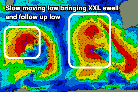 This will bring a stormy increase in localised windswell on Wednesday that'll build through the day, but an XXL W/SW groundswell is due to fill in Thursday and peak through the afternoon from the earlier stages of the low.
The earlier stages are playing out right now with a fetch of gale to severe-gale W/SW winds currently being generated north of the Heard Island region. This low will continue east with strength with even a tight embedded fetch of storm winds wrapping around its south-western flank.
This will help prolong the peak of the swell with building surf to 15ft+ due on Thursday, reaching 5-6ft in Mandurah and 3-5ft across Perth. Conditions will remain poor though with strong onshore W'ly winds, easing and tending more W/SW-SW through the afternoon.
Friday morning will remain XXL but ease with dropping sets from 12-15ft in the South West, 4-5ft+ in Mandurah and the 3-4ft range across Perth. Winds will swing offshore though as a high moves in and light E/NE winds blow across the state. It'll take a while to clean up in some locations so expect lots of leftover and lump across the South West.
As we move into the weekend the swell will continue to ease with strengthening NE tending N/NE winds as a weakening trough moves slowly in from the west.
The earlier stages of this trough will generate another large W/SW groundswell for Sunday/Monday though the stalling nature of the trough off our coast will likely continue to bring average winds. Better surf is likely mid-late next week but more on this Wednesday.