Large swells for the coming days, though with north winds

Western Australia Surf Forecast by Craig Brokensha (issued Friday 1st May)
Best Days: Selected spots tomorrow and Sunday
Recap
Much smaller surf yesterday with the swell dropping away from 3-4ft across the South West, tiny in Perth and Mandurah. Conditions were favourable all day though and this morning we've got stronger offshore winds and a building mix of long-period W/SW and SW groundswells.
Perth and Mandurah were tiny with 3-5ft waves in the South West, but we should see the swell building through the day. 6ft+ sets are no showing in the South West and we should see the swell magnets reaching 8-10ft, 3ft across Mandurah and 2-3ft in Perth. While a little slow going this morning keep an eye on the cams for this new energy.
 Sets showing and even bigger now..
This weekend and next week (May 2 - 8)
It's worth noting from the get go that the forecast models are under-representing the coming days of long-period swell with much more size than shown due across all coasts.
This afternoon's strong mix of new long-period groundswells are due to peak overnight, easing back tomorrow from 6-8ft tomorrow, 2ft to occasionally 3ft in Mandurah and 2ft+ across Perth. The possible late arrival of the swell today could help provide a bit more size on the coast into tomorrow, though we'll see.
Winds will be similar though slightly weaker than today, fresh to strong from the E/NE, tending NE through the day and then easing while tending N/NE, more variable to the north.
We then look at our larger and better W/SW groundswell due into Sunday and Monday.
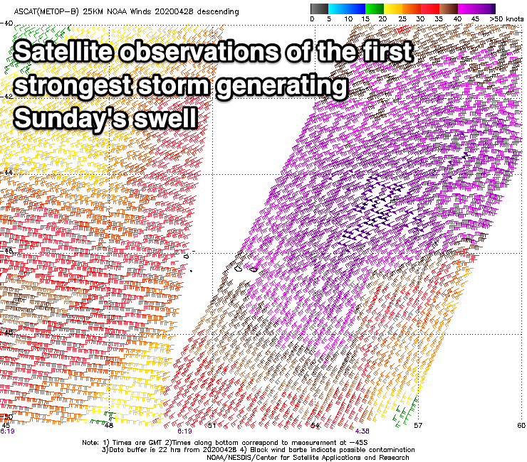
The back to back mid-latitude storms linked to these swells have already come and gone firing up south-east of Heard Island and projecting east-northeast to a position above Heard Island. The first and strongest generated a fetch of severe-gale to storm-force W/SW winds (shown on ASCAT below), while a secondary slightly weaker but broader front quickly fired up on its tail and pre-activated sea state.
Large, long-period surf should build through Sunday from the first low, likely around 6t+ at dawn across the South West but building to 10-12ft on the swell magnets, 3-4ft in Mandurah and 3ft across Perth.
The secondary swell will slow the easing trend into Monday with sets dropping from 10ft+, 3ft+ and 3ft respectively.
Looking at the local winds and unfortunately we'll be dealing with a fresh N/NE breeze from dawn Sunday swinging more N'ly into the afternoon and then N/NW later. Monday will then be poor with fresh to strong NW tending W/NW winds and then strong W/SW into the afternoon as a mid-latitude front pushes in from the west.
This will be the first in a series of not overly strong but annoying mid-latitude lows as they bring onshore winds with Wednesday looking to be large and stormy from the W/SW.
Later week we may see a stronger polar frontal progression firing up through our southern swell window generating a good swell for next weekend, but more on this Monday. Have a great weekend!
Comments
Solid sets..
Its good on Sth Coast too....looks like for next couple of days too. Yew!
It got to about 6ft if that around Margs yesty. Back to 4ft this morn.
4ft?


Actually, here's a better set that just rolled through.


Woops! Yep sorry long lulls but you guys called it. Pretty decent sets.
Phew.
Ideal winds for the south coast Mr blue diamond. Looking good up here in the north too with a bit of Westerly swell direction. Its finally cooled off too.
Fine winds indeed, after a summer of brutal Easterlies, we've got a week or so of medium to large swell and Northerlies so definitely got a spring in the step. Stoked the swells finally starting to head North and a reprieve in the weather for you crew. Enjoy!
Excellent surf today! Consistent too.
Stoked!