Large swells as winds veer north

Western Australia Surf Forecast by Craig Brokensha (issued Wednesday 29th April)
Best Days: Tomorrow in the South West when winds ease, Friday, Saturday, selected spots Sunday morning, Tuesday morning
Recap
Choppy and large surf developed across the South West yesterday, also wind affected but more surfable across Mandurah and Perth. The swell has eased into today and cleaned up across all locations with surf to 5-6ft in the South West, 2-3ft across Mandurah and 2ft in Perth.
This week and weekend (Apr 30 – May 3)
The surf will ease steadily through today and drop further tomorrow leaving tiny waves across Perth and Mandurah, better in the South West and to 3-4ft but with strong E/NE tending variable winds. Try the afternoon for a surf but expect less size.
Later in the day we may see a hint of new long-period groundswell, that being a mix of SW and W/SW energy produced by a 'bombing low' early this week.
The structure of this low wasn't ideal but the strength of the fetches generated around it and to the north significant.
 There's been no change to the expected size on Friday with building surf to 8-10ft expected across the South West, 3ft in Mandurah and 2-3ft in Perth, smaller in the morning.
Winds are due to swing a little more north Friday, strong again from the E/NE early, shifting NE during the morning and then N/NE before easing in strength.
Similar though slightly weaker but still fresh winds are due on Saturday as the swell eases.
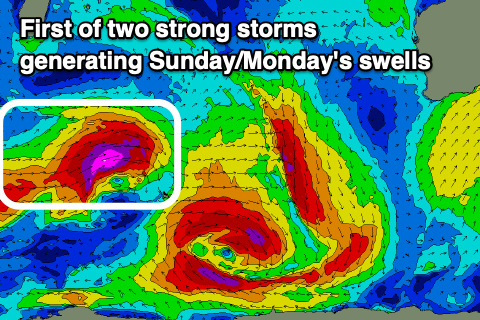
We then look at larger, long-period though slightly less consistent W/SW groundswell due across the state on Sunday.
This has been generated by a significant mid-latitude storm firing up south-east of South Africa, with a fetch of severe-gale to storm-force W/SW winds projected east on top an active sea state. The low is now weakening north of the Heard Island region, backed up quickly by a secondary broader system generating severe-gale W/SW towards us, breaking down Friday.
Back to back large, long-period W/SW groundswell should be seen from these sources, the first building Sunday with the secondary arriving later in the day and peaking Monday morning.
The South West should build to 10-12ft across the South West swell magnets into the afternoon, 3-4ft in Mandurah and 3ft on the sets in Perth later. Easing surf from 10ft+, 3ft+ and 3ft respectively is due on Monday.
Again it's worth pointing out that the models are under-representing each one of these large swells from Friday and there'll be a lot more energy and size than indicated.
Unfortunately we'll see N/NE winds Sunday morning, freshening and then stronger N/NW into the afternoon with Monday onshore under W/SW winds.
Tuesday should become smaller as winds swing back offshore from the E/NE ahead of NW sea breezes.
The rest of the week looks a bit slower on the coast, ahead of some possible new S/SW groundswell the following weekend. More on this Friday.
Comments
Very comforting reading of inbound swell. Thank you Craig.