Large swells to continue

Western Australia Surf Forecast by Craig Brokensha (issued Monday 27th April)
Best Days: Protected spots tomorrow for the keen, Wednesday, Thursday in the South West, Friday, Saturday, selected spots Sunday and Monday mornings
Recap
Lumpy and building large surf through Saturday across the South West, with the swell hanging in well yesterday morning as winds shifted offshore. Large, clean and 10t+ surf was seen for experienced chargers, with the easing trend slowed into today and back to 5-6ft.
Mandurah and Perth were solid Saturday but a bit lumpy as well, best yesterday with clean conditions and good sized sets. This morning both coasts are back to 2-3ft with great conditions continuing ahead of sea breezes.

This week and weekend (Apr 28 – May 3)
Moving into tomorrow and we've got a mix of new S/SW groundswell and some closer-range S/SW swell on the cards, generated by initially a strong burst of W'ly gales yesterday late in our swell window and tonight, a secondary fetch of strong S/SW winds.
Size wise we should see the South West kick back to 6-8ft, 2ft+ across Mandurah and 2ft on the sets in Perth, easing back through Wednesday from 5-6ft, 2ft and 1-1.5ft respectively.
 Winds tomorrow won't be ideal and strong from the S'th across the South West, S/SE to the north with Wednesday being much cleaner with E/SE offshores across the South West, SE to the north.
Thursday will be clean again with stronger offshore E/NE winds, variable into the afternoon as the swell fades, best in the South West.
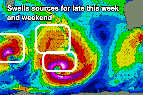
We then look to the deep and powerful low that's currently 'bombing' around the Heard Island region.
It's dropping significantly in central pressure and easily surpassing the required drop of 24hPa in 24 hours so classify as 'bomb', resulting in a fetch of severe-gale to storm-force W/SW winds being generated through our south-western swell window. The low won't be ideally structured and the fetch a little small in scope, but an additional fetch of W/SW gales north of the main low will help generate an additional W/SW groundswell into the mix.
We should see both these swells arriving late Thursday but peaking through Friday afternoon to 8-10ft across the South West, 3ft in Mandurah and 2-3ft in Perth.
Winds on Friday look similar to Thursday and fresh to strong from the E/NE, variable into the afternoon from the N/NE and then E/NE tending N/NE on Saturday as the swell eases.
We've got follow up large W/SW groundswells due on the weekend though, the first for Sunday morning and the second for late in the day, generated by a couple of strong trailing mid-latitude fronts through the Indian Ocean. The first and strongest will generate a fetch of severe-gale to storm-force W/SW winds, with a secondary system moving on the back of this, producing weaker severe-gale W/SW winds.
The models are significantly undercalling these more distant swells, with a large long-period and great W/SW groundswell due from the first storm, arriving overnight Saturday and building Sunday to 10-12ft across the South West into the afternoon, 3-4ft in Mandurah and 3ft in Perth.
The secondary swell should keep the size up through Monday, possibly followed by a third but smaller swell Tuesday.
As the fronts near closer though winds will slowly deteriorate, swinging N/NE to W/NW through Sunday, fresh NE tending N/NE on Monday. We'll have a closer look at these winds and any change to the expected swells on Wednesday and Friday.