Slow period ahead

Western Australia Surf Forecast by Craig Brokensha (issued Monday 27th January)
Best Days: Wednesday morning in the South West, desperate surfers Saturday and Sunday mornings swell magnets in the South West, Monday morning in the South West
Recap
A kick in swell from the south on Saturday but with less than favourable winds for the spots seeing the size, easing Sunday as average conditions continued. Further north conditions were cleaner but the surf tiny.
This morning the South West was cleaner with a small leftover swell to 3ft or so, tiny to the north again.
This week and weekend (Jan 28 – Feb 2)
The coming period isn't too special with smaller swells and at times less then favourable winds when they peak.
Later today and tomorrow a new S/SW groundswell is due to fill in, generated over the weekend by a slow moving polar low south of us. Sets to 4-5ft+ are due across the South West south swell magnets, tiny in Mandurah and Perth.
Winds don't look too flash for the spots seeing the size tomorrow with a moderate to fresh S/SE breeze, giving into afternoon S/SW winds, lighter and more variable on Wednesday morning out of the S/SE-E/SE but smaller and easing from 3ft to maybe 4ft.
 Onshore winds will move in on Thursday as a weak cold front pushes in from the south-west, with the earlier stages of this front generating a mid-period W/SW-SW swell for Friday.
No real size is expected owing to the fetch generating it being less than gale-force and short-lived, with Margs possibly kicking in size to 3-4ft or so. Winds won't be ideal on Friday and likely lingering from the S'th across the South West, better to the north but tiny in size.
Come the weekend, Friday's weak mid-period swell will fade as winds improve.
There's no decent size expected at all with easing sets from 3ft Saturday with a morning E/SE offshore, clean again Sunday morning but tiny.
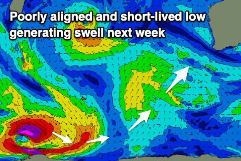
Into Monday a very inconsistent SW groundswell and mid-period S/SW swell are due, but again with no major size. The long-period energy will be generated by a tight and distant but intense polar low forming south-west of the Heard Island region this evening. A burst of W/NW severe-gale to storm-force winds will be aimed poorly through our swell window, with the swell due to build Sunday afternoon, reaching 3-4ft+ in the South West but with sea breezes, easing from 3-4ft Monday.
A smaller and weaker mid-period S/SW swell should be seen from a weak polar front just skirting our swell window on the weekend. Local winds Monday should be offshore from the E/SE, similar Tuesday morning as the swell fades.
Unfortunately longer term there's still nothing significant on the cards but we'll review this on Wednesday so check back then for an update.
Comments
These South/Southwest swells are getting the job done further south...nothing epic but a constant run of bread and butter beachies.
That's good to hear :)