Average week, large powerful swell building for the weekend but onshore

Western Australia Surf Forecast by Craig Brokensha (issued Monday 16th April)
Best Days: Early Wednesday Mandurah and Perth, Thursday morning all locations, desperate surfers across magnets Friday morning
Recap
After a large and fairly consistent increase in SW swell through Friday afternoon, Saturday was as expected slower but large and strong when the sets came, best in protected spots. Mandurah was clean and back to 2-3ft, 2ft in Perth.
Sunday was much cleaner and still in the 6ft+ range across Margs, small and 2ft around Mandurah with tiny waves in Perth. We've got a further drop in size today favouring magnets across the South West dropped from 3-5ft this morning (tiny to the north).
Today’s Forecaster Notes are brought to you by Rip Curl
This week and weekend (Apr 17- 22)
The coming couple of days aren't looking too flash across the coast with the swell easing further tomorrow while the mid-latitude low that's due to generate a mid-period W/SW swell from the central Indian Ocean moving in from the west, bringing onshore winds.
We'll see poor and fresh W/SW-SW winds all of tomorrow, SW all day Wednesday across the South West (S/SE early around Mandurah and Perth).
The W/SW swell from the low should fill in Wednesday providing fun 2ft+ waves across Mandurah, 2ft sets in Perth and 4-6ft sets in the South West.
 We'll see the mid-period W/SW swell easing through Thursday from 4ft on the sets across Margs and 1-2ft further north, with a slight improvement in winds, light S/SE across Margs and E/SE in Mandurah and Perth.
Friday will be small and weak with light morning E/NE winds swinging NW into the afternoon with an approaching front.
Now, our oversized W/SW groundswell for next weekend is still on track, but the high that would of provided favourable winds now will be pushed away by the remnants of the storm resulting in poor onshore conditions.
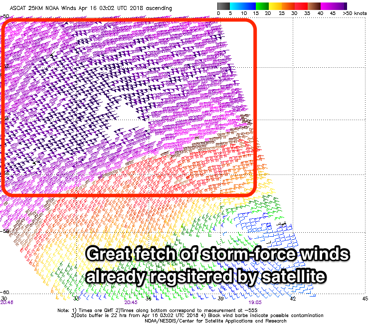
Coming back to the storm, and a large and powerful low has already formed south of South Africa, with a fetch of severe-gale to storm-force W/SW winds already picked up by satellite.
We're seeing similar strength winds projected through our western swell window today and early tomorrow while slowly projecting east-northeast, with the storm due to weaken while continuing to push east through tomorrow evening, and more so Wednesday and Thursday.
We'll see a very large long-period and strong W/SW groundswell generated by this storm, though it will be very inconsistent, with the forerunners arriving late Friday, with the bulk of the groundswell filling in Saturday and peaking into the late afternoon/evening.
Swell magnets should build to 10ft+ range across the South West later Saturday, though very inconsistent with 3-4ft sets in Mandurah and 3ft sets in Perth though the remnants of the storm will move in bringing terrible and fresh NW tending W'ly winds, SW into Sunday and a bit stronger as a secondary mid-latitude front pushes in adding some moderate sized windswell to the mix.
There's a chance of more variable breezes on Monday but we'll review this Wednesday.
Comments
Looking good at home in Exmouth from Sunday