Easing surf with clean conditions most of tomorrow, stormy swell Monday

Western Australia Surf Forecast by Craig Brokensha (issued Wednesday 10th May)
Best Days: Thursday, Friday and Saturday mornings around the South West
Recap
Onshore average waves to start yesterday with a strong and large increase in groundswell and windswell across the state through the day.
The large W/SW groundswell held into this morning with large clean 8-10ft waves in the South West, 3-4ft surf around Mandurah and 2-3ft sets in Perth. The swell has already started to ease and will continue to do so through tomorrow.
This week and weekend (May 11 – 14)
This morning's W/SW groundswell will be still a good size across the South West tomorrow morning, coming in around 6ft, if not for the odd bigger one, with easing 2ft sets to the north. Conditions look great with a straight E'ly offshore, giving into mid-late afternoon sea breezes.
Friday morning will be smaller but conditions are looking clean early with variable breezes ahead of afternoon sea breezes.
Come Saturday morning NE winds will favour swell magnets as the swell continues to bottom out.
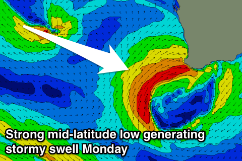 From Sunday we'll see some new mid-period swell along with stormy short-range W/SW swell filling in. The mid-period energy will be generated by weak back to back polar fronts projecting towards us over the coming days, with the secondary system forming into a mid-latitude low off our coast Saturday.
This low will then move into towards us Sunday, but isn't expected to be as strong as forecast on Monday, with a fetch of strong to gale-force W'ly tending W/SW winds slammed into us through the evening. The low should start to weaken Monday and move slowly east.
What we should see is poor levels of W/NW windswell building Sunday with the mid-period SW energy along with strengthening W/NW winds.
A peak in stormy W/SW swell is due Monday to the 10ft range across the South West and 3ft in Perth but with strong W/SW winds.
As the low slowly weakens and pushes east, we'll see the swell easing from the SW Tuesday with fresh S/SW winds, smaller Wednesday.
Longer term some inconsistent long-range SW groundswell is due late next week but winds may become a bit of a problem with some mid-latitude frontal systems encroaching from the west. More on this Friday though.
Comments
Another day, another pumping swell in Margs..