Another large W/SW swell, cleanest as it eases

Western Australia Surf Forecast by Craig Brokensha (issued Monday 8th May)
Best Days: Wednesday, Thursday, Friday morning in the South West
Recap
Pumping waves Saturday with a large clean easing swell from the 10ft range in the South West, 3-4ft around Mandurah and 2ft to occasionally 3ft on the Perth metro beaches.
Winds remained favourable all day with variable breezes into the afternoon.
Sunday was still solid in the South West with clean 6ft+ surf, easing through the day and dropping 2-3ft waves around Mandurah, 2ft in Perth.
Today the swell was much smaller and with alight onshore wind in the South West, cleaner but tiny to the north.
This week and weekend (May 9 – 14)
With the weekend's large clean swell but a distant memory this morning, we look to the next significant swell event, that due tomorrow and Wednesday.
Since late last week a very intense and broad polar storm has been moving through the Southern and Indian Oceans, generating a very large and powerful W/SW groundswell.
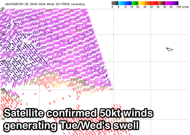 Satellite observations confirm an expansive and persistent fetch of severe-gale to storm-force winds projected through our western swell window, and this system is currently weakening while approaching us from the west-southwest.
We'll see the remnants of the progression moving across us tomorrow, bringing poor onshore W/SW winds, easing through the day as a mix of mid-period W/SW and larger W/SW groundswell fill in.
We're looking at a touch less size than forecast Friday with Margs due to build to 10-12ft later tomorrow, easing from a similar size Wednesday morning. Perth should increase to 3ft later tomorrow with 3-4ft sets around Mandurah, easing from a similar size Wednesday morning.
Winds are looking poor most of tomorrow, only easing later, but Wednesday should be good in semi-protected locations with a light to moderate SE'ly ahead of sea breezes in Perth and S/SE winds in the South West.
Thursday looks excellent with straighter offshore E/SE to E'ly winds, tending variable into the afternoon and easing 6ft+ sets in the South West, 2ft to the north.
Friday will be smaller and an early E/NE breeze will favour magnets ahead of a weak onshore change.
Moving into the weekend, Saturday will remain small but clean through the morning, while we've got a very large and stormy W/SW swell on the cards for later Sunday/Monday.
This will be due to a deep and powerful mid-latitude low forming directly off our South West coast, stalling and aiming a fetch of severe-gale to near storm-force W/SW winds into the region.
Strong to gale-force onshore winds will accompany the swell as it peaks Monday, with improving conditions Tuesday as the low moves off to the east. More on this Wednesday though.
Comments
Another great satellite pass showing how expansive the weekend's storm was..
Thats excellent craig Cheers
Very solid at Margs today. Can really see the pronounced W in the swell direction too.
Solid swell here at Jakes point today. Good winds.Might put a clip up later on.
Lurvely.
Bit of Dog action at the start. Ruined one of the waves of the day hehe.
Sick!! The start is epic, haha.
See how the swell direction comes into metro beaches from a nw direction . This is a perfect example here on the directional graph data.
http://www.transport.wa.gov.au/imarine/cottesloe-tide-and-wave.asp
Yeah saw that!! Currents affecting it?
This is from 3 days ago, but the Leeuwin Current was quite strong..
Although Rottnest Island observations aren't being steered W/NW and they are closer to the strong currents. Weird.
Hey Craig , ive been watching CB for 2 months and its wnw direction swell almost every day on the arrow . I dont believe current as much as the fact the waters too shallow in the sw direction so swell probably does come around the north of rotto .
FYi the Rottnest buoy averages a more west direction on average than any other buoy . The perth canyon , LC and bathymetry does this, according to my long term buoy obs .
The cott buoy shows pure wnw at times on the arrow but this week and today it has sw and nw direction combined . See graph )
I had never studied the cott buoy for obvious reasons before now . I plan to watch it for a year before making an official claim about it, as it could certainly (both cott and rott ) be current affected perhaps ?
http://www.transport.wa.gov.au/imarine/cottesloe-tide-and-wave.asp
Please post my picture will send it mms to you craig .
When the university did the study a few years ago . ( you still have the report craig , wouldn't mind it back if you can find it ) this was not mentioned , Ive never heard of anyone mention this before .
Yeah I've still got it somewhere. WIll try and find it online for you.