Large clean swell Saturday, bigger swell next week

Western Australia Surf Forecast by Craig Brokensha (issued Wednesday 3rd May)
Best Days: Late Friday, Saturday, Sunday morning, early Monday
Recap
Another great morning of waves yesterday across the South West with a stiff offshore wind and easing 4-6ft surf, remaining clean into the afternoon with more variable breezes. Perth eased from a smaller 1-2ft.
Today conditions were less then ideal with half the amount of swell and a fresh NE breeze that has since swung more N'th.
This week and weekend (May 4 – May 7)
Currently to our west-southwest a vigorous polar frontal progression is aiming a broad fetch of gale to severe-gale W/SW winds through our swell window.
This progression formed Monday afternoon and will continue to roll east through our western swell window while generating gale to severe-gale W/SW winds.
A large, powerful and consistent W/SW groundswell will result, with some pre-frontal swell building tomorrow but with fresh onshore W/NW winds ahead of the groundswell proper Friday.
We should see Margs building to the 10ft range by dark (2-3ft in Perth) ahead of a peak Saturday morning to 10ft to occasionally 12ft at exposed breaks, easing through the day.
Winds on Friday will remain onshore from the W/SW, tending lighter and more variable into the late afternoon.
 Saturday is still looking excellent with light offshore E/NE winds, variable into the afternoon, with less favourable E/NE tending NE and then N/NW winds Sunday.
Monday morning will be smaller again with variable winds at dawn, increasing from the N/NW during the morning.
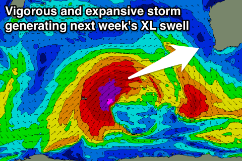
As talked about last update an even stronger storm is forecast to develop in the southern Indian Ocean later this week, with a vigorous polar frontal progression due to take a similar track to that of this week's but with stronger core winds and over a greater expanse of ocean.
We'll see a severe-gale to storm-force fetch generating a large powerful long-period W/SW groundswell which should arrive Tuesday and build rapidly into the afternoon.
The South West is expected to spike to an XL 12ft+ across the South West with 3-4ft sets in Perth. Unfortunately it looks like the remnants of the progression will move into us Tuesday bringing strong NW tending W/SW winds, lingering from the W/SW Wednesday as the swell eases.
We'll have another look at this Friday though.