Great Saturday, pumping Monday and XL late week

Western Australia Surf Forecast by Craig Brokensha (issued Friday 28th April)
Best Days: Saturday, Monday, Tuesday, Wednesday morning, Friday
Recap
Tiny waves around Perth and Mandurah, while Margs saw fun 3ft sets at magnets yesterday morning, even smaller today and back to 2-3ft.
Our new SW groundswell due this afternoon is now showing across the South West with clean 4-5ft+ sets. We'll see this swell continuing to build and reaching 5-6ft by dark but with weak sea breezes.
This weekend and next week (Mar 29 – May 5)
This afternoon's SW groundswell should hold through tomorrow with clean 5-6ft waves in the South West and inconsistent 1-2ft waves around Perth with a light E/NE offshore wind, tending variable ahead of late and weak sea breezes.
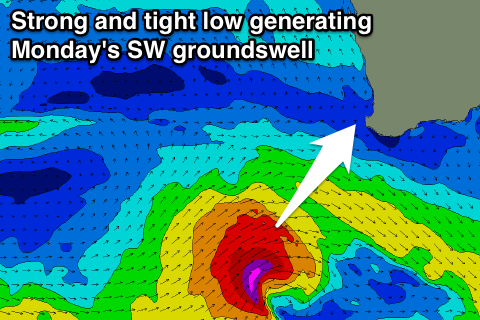 The swell should start to ease back through Sunday and conditions are now looking average as a strong mid-latitude low develops to our south-west, bringing freshening SW tending S/SW winds ahead of a late swing back to S/SE.
This low should also generate a new large SW groundswell Monday, with a fetch of severe-gale SW winds forecast to be generated directly south-west of us.
This swell looks to come in at 6-8ft across the South West and 2ft further north with offshore E/SE winds as the low clears off to the east. Tuesday will also be great as the SW swell eases off steadily under an E/NE tending variable breeze.
Also in the mix will be a long-range and inconsistent W/SW groundswell for Tuesday morning, produced in our far swell window south-east of South Africa. This should help slow the easing trend from 5-6ft across the South West and 2ft in Perth, smaller Wednesday with NE tending N'ly winds.
As talked about last update, there's some larger swell on the cards for late week, and this swell is now looking to be in the XL size-range.
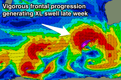 A strong node of the Long Wave Trough developing in the south-east Indian Ocean will direct a flurry of vigorous polar frontal activity up and towards us from the weekend through early-mid next week.
An initial distant polar storm should generate a moderate to large SW groundswell, but this will be overridden by a high-riding and intense mid-latitude system, projecting a fetch of severe-gale to storm-force W/SW winds over an active sea state and towards us.
This should produce an XL W/SW groundswell for Friday which at this stage looks to come in around 12-15ft across the South West and 3ft+ in Perth. A ridge of high pressure will deflect the storms away from us late week as well resulting in offshore winds, but more on this Monday. Have a great weekend!
Comments
The wind is still offshore and the surf on forecast in WA this afternoon.
Check the size of this one this guy paddled..
Iddzy