XL swell for the weekend, cleanest as it eases

Western Australia Surf Forecast by Craig Brokensha (issued Friday 17th March)
Best Days: Sunday protected spots, Monday morning, Tuesday and Wednesday mornings swell magnets in the South West
Recap
Pumping surf across the state yesterday with Wednesday's XL swell easing back under straight offshore winds. Margs saw clean 6-8ft surf with 2-3ft waves to the north.
Today the swell was half the size with clean conditions early across all coasts, but winds have since shifted onshore.
This weekend and next week (Mar 18 - 24)
We're looking at our second XL swell within a week over the weekend, building strongly through tomorrow before peaking overnight and easing Sunday.
The vigorous low pressure system linked to the swell has projected a fetch of severe-gale to near storm-force SW winds towards us the last couple of days from the Heard Island region.
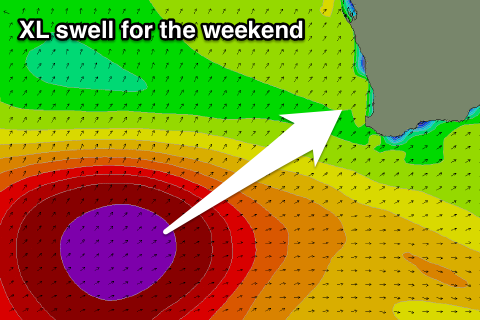 The system is currently well west-southwest of us and weakening, with two separate pulse of long-period SW groundswell due to fill in tomorrow. The first is due through the morning, with the largest closely behind it, building rapidly through the afternoon to 12-15ft by dark at swell magnets.
A slow drop in swell is expected Sunday from 10ft to occasionally 12ft, half the size by Monday.
Perth will be tiny early but a kick to 3ft is due into the evening Saturday, easing from 3ft on the sets Sunday morning.
Winds are still looking onshore tomorrow and from the W/SW-SW, but Sunday should see SE offshores across Perth, while Margs bay be S/SW at dawn, tending S/SE through the morning and persisting into afternoon. Therefore hit up protected breaks.
Monday looks much better with easing 4-6ft sets in the South West under a straight offshore wind and 1-2ft waves to the north around Perth.
For the rest of the week we're looking at offshore winds until about midday Thursday but there'll be no decent swell on offer. A small S/SW groundswell Wednesday should keep the South West topped up with 3-4ft sets.
Longer term there's nothing significant due until a moderate sized long-period SW groundswell arrives Friday and peaks Saturday, but more on this in Monday's update. Have a great weekend!
Comments
Saturday evening, solid!!