Dual XL swells incoming

Western Australia Surf Forecast by Craig Brokensha (issued Monday 13th March)
Best Days: Thursday, Saturday afternoon and Sunday protected spots
Recap
No surf over the weekend but with good conditions.
Today everywhere started onshore and small, but some new groundswell and windswell has developed across all regions but with terrible conditions.
This week and weekend (Mar 14 - 19)
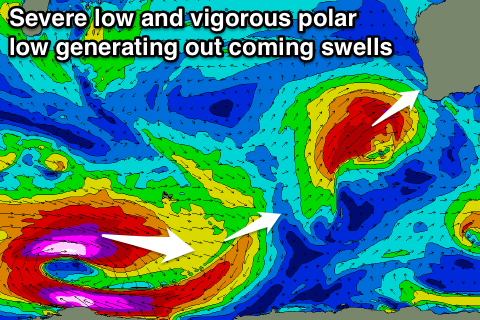
As talked about last week, we've got a severe low and large XL storm swell due across the South West mid-week.
Currently a polar front is strengthening to our south-west, with a fetch of severe-gale to storm-force SW winds due to be projected up and into us over the coming 24-48 hours.
The swell will come in from a W/SW direction across the South West, and more SW to the north, with building levels of W'ly windswell tomorrow ahead of the groundswell proper Wednesday.
Conditions will be terrible with strong to gale-force W/NW winds tomorrow, while as the swell peaks Wednesday fresh S/SW winds will ease off through the day.
 We should see XL storm surf to 15ft Wednesday across the South West, with 4ft surf around Perth.
Thursday looks excellent across all locations as a ridge of high pressure moves in quickly overnight Wednesday, swinging winds straight offshore from the E. The swell will be easing quickly from 6-8ft in the South West and 2-3ft to the north.
A low point in swell is due Friday but early variable winds should provide fun waves at magnets in the South West before another strong approaching front brings freshening W/NW winds.
This frontal system is very significant.
It's already started its life south-east of South Africa as a broad and intense polar low. We're seeing a fetch of severe-gale to storm-force and close to hurricane-force W'ly winds being generated in our far swell window, with the system due to track slowly east and the north-east through our swell window over the coming days.
We'll see an XL long-period SW groundswell generated building strongly and rapidly through Saturday and reaching 12-15ft across Margaret River by dark, bigger at offshore bommies, with 3ft+ sets in Perth.
A slow easing trend is due Sunday but onshore S/SW winds look to create average conditions through most of this swell event. We'll have a closer look at this Wednesday though.