Fun swell for the weekend with stiff offshores

Western Australia Surf Forecast by Craig Brokensha (issued Wednesday 8th February)
Best Days: Saturday, Sunday, Monday morning in the South West
Recap
Poor winds and surf yesterday, a little bigger today with a S/SW windswell but very average conditions.
This week and weekend (Feb 9 - 12)
Tomorrow, a slightly stronger mid-period SW swell is due across the South West, coming in at 3-4ft, but winds are now looking more SE in direction while also being fresh to strong.
This will limit options to slightly protected breaks. Perth is expected to ease from 1ft.
Even stronger SE winds on Friday and fading swell will create poor conditions.
 Into the weekend, our better pulses of SW groundswell are still due, but the size looks to have been downgraded slightly.
The polar frontal progression that developed west of Heard Island is now moving closer towards as, but wind strengths are due to be just below the gale-force range.
With this we're probably only expecting to see sets reaching 4-5ft into Saturday afternoon, easing from a similar size Sunday morning. There may be the odd bigger one in the mix at times, while Perth looks to come in at 1-1.5ft.
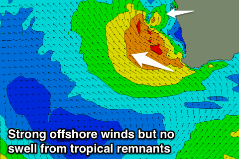
Strong E/SE breezes will blow all day Saturday as the remnants of a possible tropical cyclone forming off our north-west drifts south and squeezes a strong ridge of high pressure.
No swell is due off this system though with no considerable N-NW fetch being generated in our swell window.
Straighter E'ly offshores are expected on Sunday and also a touch weaker, with E/NE winds Monday morning as the swell continues to ease from 3-4ft or so around Margs.
Longer term a good fun long-period SW groundswell is due to fill in Thursday, generated by an intense polar low around the Heard Island region, projecting north-east towards us.
We might see 5-6ft of SW groundswell with a light morning SE breeze, but we'll have another look at this Friday.
Comments
Gutted we're not going to see any NW/NNW swell from that tropical low!
G day Craig, I'm noticing that other models are calling waves well into the 6 foot plus range for Saturday AM. I'm assuming you're calling it at 4 to 5 because of the acute southerly direction?
Thanks.