Small surf for the period

Western Australia Surf Forecast by Craig Brokensha (issued Monday 30th January)
There's only TWO DAYS left to sign up for the P-Pass competition! Sign up to Swellnet’s newsletter and receive the West Australian Forecaster Notes and latest news sent directly to your inbox. Upon signup you'll also enter the draw to win a surf trip to P-Pass for you and a mate. It doesn’t get much easier so click HERE to sign up now.
Best Days: Tuesday and Wednesday morning in the South West, Thursday morning swell magnets, similar Sunday and Monday
Recap
A fun swell across the South West Saturday with morning offshores and 4-5ft sets before a SW change moved through late morning. Perth and Mandurah were small to tiny.
Sunday saw poor conditions with lingering onshore winds, but today a good new SW groundswell has peaked with offshore winds.
Margs is seeing good 4-6ft sets with an increase to 1-2ft across Manudrah and Perth through the day.
This week and weekend (Jan 31 – Feb 5)
From this afternoon a slow easing trend is due across the state, through tomorrow and further Wednesday, bottoming out Thursday morning.
The easing trend will be slowed by a reinforcing mid-period swell generated by a relatively weak mid-latitude front currently south-west of us.
 Margs should ease back from 3-4ft+ tomorrow morning, with 1-1.5ft sets in Perth, further from 3ft Wednesday morning.
Gusty offshore E/SE winds are due tomorrow morning, tending more SE into the afternoon, with E/SE-SE winds Wednesday morning, S/SE onto the afternoon.
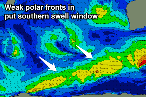
Unfortunately for the rest of the week there's no major swells on the cards with weak polar fronts through our southern swell window over the coming day preventing the Margaret River region from bottoming out.
Small inconsistent 2-3ft waves are due Thursday and Friday a touch stronger Saturday.
Conditions should remain good for exposed breaks Thursday morning, tending back to the S/SE Friday and Saturday.
Besides another small weak S/SW swell Sunday the surf will really slow down into early next week, becoming near flat on Tuesday afternoon and Wednesday.
Longer term we may see some stronger fronts forming mid-next week, generating swell for late week and more so into the following weekend, but more on this Wednesday.
Comments
Thanks Craig, so we will not get any northerly swell from the cyclone? Is that due to the swell direction generated by the cyclone or that it did not travel SW enough to impact us?
Cheers PK
Yeah see this image..
There's no decent northerly fetch at all. Just that south-east fetch on its south-western flank.