Great waves tomorrow, fun Wednesday, wind affected Thursday

Western Australia Surf Forecast by Craig Brokensha (issued Monday 22nd August)
Best Days: All regions Tuesday, Wednesday and Thursday morning
Recap
Choppy poor waves across the South West with small to moderate amounts of swell, while Perth and Mandurah were better with more favourable winds and 1-2ft surf.
Today a bit more size was seen across the South West with a building W/SW swell and gusty S'ly winds, while further north S/SE-SE winds created less than ideal conditions.
This week (Aug 23 - 26)
The large W/SW groundswell filling in through today has been downgraded just a touch but should peak overnight and ease back from 6-8ft+ tomorrow morning across the South West and 2ft+ in Perth.
Conditions are looking great for the South West now with a ridge of high pressure moving in this afternoon, resulting in light to moderate E'ly tending E/NE offshores across the South West (E/SE Perth), variable into the afternoon.
Wednesday morning should be smaller again with E/NE tending NE winds through the morning, variable into the afternoon,
Some new long-period SW groundswell is due very late in the day across the South West, generated by a pre and post-frontal fetch of severe-gale NW-W/SW winds currently east of Heard Island.
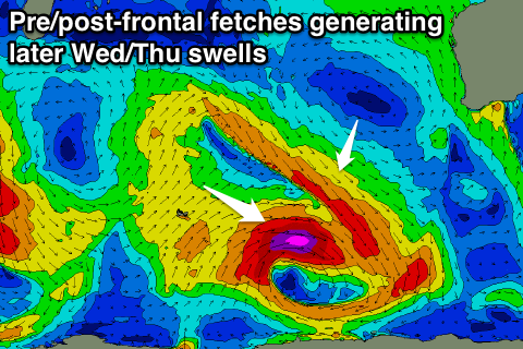 The late kick is from the pre-frontal winds, with the post-frontal fetch producing a slightly better pulse for Thursday morning.
The South West should kick back to 6ft later Wednesday, with Thursday morning seeing good 5-6ft+ sets, easing through the day. Perth isn't due to see much size, with 1-2ft sets Thursday morning.
Winds will take even more of a NE'ly bias Thursday, moderate to fresh from the NE early, tending N/NE into the afternoon.
This will be linked to an approaching mid-latitude low, with gusty N/NE tending N/NW winds on Friday and then NW winds Saturday.
This low won't be ideally positioned for swell production across our region, with the strongest winds being from the S/SE on the south-west flank of the low. As the low slowly moves into us though a strong fetch of W/NW winds will be aimed across the south of the state Saturday, kicking up moderate to large levels of W/NW windswell, veering more SW-S/SW as the low continues moving east Sunday and winds swing SW.
This low will dominate our swell window and surf into early next week before dissipating Tuesday. More on this Wednesday though.
Comments
Pumping in Margs this morning!
Yallingup also looking a treat!
https://www.swellnet.com/surfcams/yallingup
Pumping this morning!