Fun from Sunday with a large swell for Wednesday

Western Australia Surf Forecast by Craig Brokensha (issued Friday 30th October)
Best Days: Sunday morning, Monday
Recap
Clean fun waves across the South West again yesterday morning to 3-4ft or so, with tiny surf to the north. Onshores have moved in today with the swell remaining on the slow side, leaving no options for a wave.
This weekend and next week (Oct 31 – Nov 6)
Tomorrow will be another lay day with lingering onshore SW winds across Margs, while Perth may see lighter and more variable breezes but with no decent size.
Into Sunday our mix of short-range S/SW swell and long-range SW groundswell for the late afternoon are still on track. A burst of S/SW gales should be aimed through the South West's southern swell window this evening and early tomorrow, producing a short-lived pulse of S/SW swell dawn Sunday to 4-5ft across exposed breaks. Into the late afternoon a new inconsistent SW groundswell should provide stronger 6ft sets, easing into Monday from 5-6ft or so.
Perth isn't expected to see any of the S/SW swell and the long-range energy is likely after dark, fading from 1ft to possibly 2ft Monday morning.
Winds on Sunday morning will be great and moderate offshore from the E/SE across the South West and E/NE up at Perth with NW onshores due into the afternoon across Perth, and more S/SE winds in the South West.
This onshore flow is now expected to continue around Perth into Monday, with a small windswell also being kicked up, while the South West should see morning offshores before shifting SW.
Come Tuesday the surf will be smaller and easing with variable tending offshore winds likely across both regions.
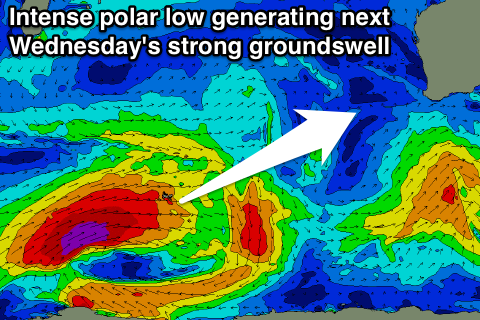 Our large and powerful SW groundswell due Wednesday is still on track, with a vigorous and favourably tracking polar low due to develop west of Heard Island this evening, projecting a fetch of severe-gale to storm-force W/SW winds towards us while tracking east over the weekend.
The low will weaken just east of Heard Island, with a secondary fetch of weaker SW winds developing south-west of us early next week. This will result in an inconsistent but strong SW groundswell for Wednesday, peaking into the afternoon, with some mid-period and more consistent SW swell in the mix.
The South West is expected to build strongly through the day and reach 6-8ft across exposed breaks, with the odd 10ft bomb through the afternoon. Perth should kick to 2ft, with the chance for the odd 3ft bomb mid-late afternoon.
Winds are looking to be light through the morning and hopefully offshore, with similar conditions Thursday morning as the swell eases, but we'll have to review this one more time Monday. Have a check back then for the latest update on the local conditions with this good swell.
Comments
The new swell is here! Looking very nice across the lower SW.
Smaller today but how are these peaks!