The out look for the end of the week still looks grim. Large swell due Saturday

West Australian Surf Forecast by Guy Dixon (issued Wednesday 9th September)
Best Days: Sunday morning, Monday morning, Tuesday
Recap:
Tuesday was on for young and old. The South West was offering pumping 6ft surf with occasional 8ft sets under light east/southeasterly winds. Once the sea breeze kicked in during the afternoon a few bumps developed on top, however winds remained light and variable further north allowing for a fun afternoon session.
Metro beaches were offering clean 2ft sets with light offshore breezes in the morning, only deteriorating slightly in the afternoon as a light westerly breeze picked up.
The swell eased back to around 3-5ft across the South West this morning, but light easterly winds kept conditions clean and groomed. Winds have since picked up this afternoon and have been slowly swinging around to the north causing the quality to drop as a result. Conditions are bumpy and the only chance of scoring a wave with any sort of shape is at a protected northern corner.
As for Perth and Mandurah, the surf has faded back to around 1-2ft with light/moderate northerly breezes only creating a few subtle bumps on top.
This week (Thursday 10th - Friday 11th):
We are looking at a slight increase in groundswell on Thursday as a subtle pulse of background energy fills in. The South West should see inconsistent surf in the 4-5ft range while Perth and Mandurah virtually miss out completely, continuing in the 1ft range.
A front will be moving over the South West first thing tomorrow so winds will be fresh/strong northwesterly, swinging through to westerly by the afternoon. This brisk air stream will add a short range wind swell into the mix providing messy low quality surf in the 2-3ft range for Perth and Mandurah.
An offshore low which has been circulating northeast of Heard Island throughout today generate a pulse due to make landfall on Friday. The surf will kick to around 6-8ft across the South West and 2ft+ for the Metro beaches.
Once again we can expect a fresh/strong northwesterly breeze throughout the day whipping up yet more wind swell and pretty much ruining any chance of a decent surf.
This weekend (Saturday 12th - Sunday 13th):
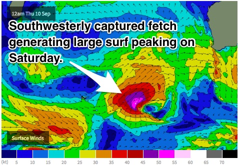
The surf will build strongly late Saturday from a well aligned captured southwesterly fetch of 45-55kt winds which will have been moving south and east of Heard Island. The South West can expect 8-10ft surf, with 12ft sets late in the day, likely peaking overnight. Perth and Mandurah will do the best off a westerly fetch off the northern flank of this system which will maintain surf in the 2-3ft range.
Unfortunately winds will continue to be shocking throughout the day. The South West will be under a fresh west/southwesterly flow tending south/southwesterly and easing marginally in the afternoon, while Perth and Mandurah will suffer a similar fate.
If you’re looking for a surf, wait for the late session when winds will be at their lightest and most southerly and head to a protected spot for the best conditions.
Sunday will see an easing trend off the back of this strong pulse, but remaining large in the morning. Winds also look to improve as a ridge builds overhead.
The South West will see surf in the 10ft (with a few 12ft bombs at dawn) for the South West with and 3ft for Perth and Mandurah.
Sunday morning looks to be the next best opportunity for a wave with light moderate southerly breezes early across the South West. There should be increasing options at the protected spots, although winds will tend southwesterly in the afternoon.
Further north, Perth will be under a light east/southeasterly breeze early tending south/southwesterly late but remaining workable. Mandurah will start off under a light southeasterly breeze tending south/southwesterly in the afternoon but also not having too much impact.
There is some model uncertainty regarding the strengths of these breezes. Some trustworthy models suggest that southerly breezes will infect be moderate/fresh, but the situation will likely come into line by Friday’s forecast notes.
Next week (Monday 14th onward):
Monday will see the surf fade further with the southwest dropping back to the 6ft range and Perth and Mandurah settling for weak 1-2ft peaks.
Winds are highly dependent on the position/timing of a front, or in other words, how long a ridge can hold on for.
At this stage, it looks as though breezes will be moderate/fresh in the morning for the South West, swinging from south/southwest early through to south/southwest in the afternoon, lighter further north.
Perth will see a light southeasterly breeze early, followed by a light south/southwesterly breeze in the afternoon. Mandurah can expect a light but workable southerly breeze early, with the same south/southwesterly breeze kicking in later.
Tuesday will see moderate southeasterly breezes prevail throughout the day right across the coast, presenting a set up much more conducive to surfing.
By then, the South West should be seeing inconsistent 4-6ft surf with background energy filling in off a prefrontal fetch in Indian Ocean. This subtle pulse looks to be generated from a system located at relatively high latitudes which would provide Perth and Mandurah with inconsistent 1-2ft surf.