Dicey days ahead, larger swell next week with varying winds

Western Australia Surf Forecast by Craig Brokensha (issued Wednesday 1st July)
Best Days: Friday morning, Sunday morning, protected spots Wednesday, Thursday morning
Recap
Fun pulse of SW groundswell to the 4-6ft range yesterday morning across the South West, 2ft around Perth and Mandurah with favourable winds for most of the day.
Today the swell was smaller and clean again early but winds have since gone more N'ly.
This week and weekend (Jul 2 – Jul 5)
A new SW groundswell due later today across the South West should be reinforced by a secondary pulse tomorrow to 5-6ft across Margs, 2ft in Perth, and coming in across the North West Friday to 4ft.
Conditions tomorrow will be average across Margs with a fresh N/NE tending N/NW breeze (NE early around Perth but tiny).
Friday morning will be better with variable winds due across Perth and Margs as the swell eases away.
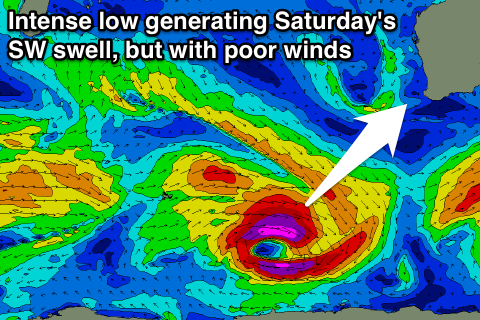 Saturday morning's pulse of SW groundswell has been upgraded a touch but winds are now looking poor.
The intense but unfavourably tracking polar low to our south-west is currently generating a fetch of severe-gale to sub-storm-force W'ly winds on the edge of our swell window, producing a good SW groundswell to the 5-6ft+ range in the South West and 2ft up in Perth. The North West should see the swell Sunday to 3-4ft or so.
Winds will be fresh onshore from the W/NW with an approaching front in the South West, with a period of variable winds possible at dawn around Perth. Sunday still looks dicey with a lingering onshore wind (possibly tending variable) and easing swell.
A small reinforcing W/SW swell isn't due Sunday from a weak low to our west, but this will just soften the easing trend.
Next week onwards (Jul 6 onwards)
As touched on last update, a strong node of the Long Wave Trough is forecast to push through the Indian Ocean later this week and weekend.
With this, initially a couple of strong polar fronts are due to fire up south-east of South Africa, in our far swell window, and then push east through our western swell window from tomorrow through the weekend and into early next week.
A mix of long-range and medium-range W/SW groundswell are due to arrive around a similar time through the day Tuesday, peaking Wednesday to 8-10ft+ in the South West, 2-3ft in Perth and 6-8ft in the North West.
Winds are looking dicey and best for protected locations as a trough and strong high pressure ridge moves in from the west, bringing strong S/SE winds.
Thursday looks better on the backside of the swell around Perth with offshores, while Margs may see another approaching front bringing W/NW winds. More on this Friday.
There's plenty of follow up energy due into the following weekend and week as the LWT strengthens further next week, but we'll discuss this in more detail Friday.