Large swell building Wednesday, easing into the weekend

Western Australia Surf Forecast by Craig Brokensha (issued Monday 20th April )
Best Days: Tuesday morning swell magnets, Wednesday, Thursday morning in protected spots, Friday onwards
Recap
Well what a day Saturday was! The final pulse of large swell filled in from the S/SW during the day offering clean 10-12ft waves across Margs with larger sets at deep water reefs. Winds remain perfect all day as expected with an offshore tending variable breeze across most breaks.
Perth was clean and around 2ft, kicking a bit more into the afternoon before easing from the 2ft range yesterday. Margs eased from 6-8ft under E'ly tending E/NE and then variable breezes.
Today the swell was much smaller again and around 3-4ft in the South West with 1-2ft sets in Perth under all day offshores.
 This week (Apr 21 – 24)
The surf should continue to drop through tomorrow with swell magnets in the South West performing best under E/NE tending N/NE winds ahead of sea breezes.
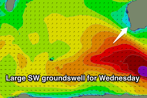
Our new inconsistent SW groundswell due Wednesday is still on track with a vigorous polar low firing up just west of Heard Island over the weekend, aiming a fetch of severe-gale to storm-force W/SW winds towards us. The low is currently weaker and to our south-west this morning, with a fetch of W/SW gales continuing to be aimed towards us this evening and tomorrow morning.
A large SW groundswell will result, arriving through Wednesday morning and building to 8-10ft+ across the South West during the day, and 2-3ft up around Perth into the afternoon. Gero should kick late to 4-5ft and easing from a similar size Thursday morning.
Winds are looking good but not great around Margs with a moderate to fresh E/SE offshore ahead of S/SW sea breezes, while Perth and Gero should see morning E/NE winds.
As the swell eases Thursday stronger SE winds are due across Margs, limiting options to more protected breaks.
The easing trend through Thursday, Friday and Saturday will be slowed by some reinforcing S/SW swell from a couple of weaker polar fronts piggy-backing on top of the initial system through the rest of the week.
Margs should ease from 5-6ft Friday with 1-2ft sets up around Perth, further down from 3-4ft+ and 1ft respectively.
Winds should improve from Friday with strong E'ly offshores through the morning, easing into the afternoon while Saturday should see strong but easing E/NE winds.
This weekend onwards (Apr 25 onwards)
Longer term we've got nothing significant on the cards at all with the westerly storm track going relatively quiet, but we'll have a closer look at this on Wednesday.