Couple of better swells but with average winds at their peak

Western Australia Surf Forecast by Craig Brokensha (issued Wednesday 10th December)
Best Days: Thursday morning Margs and Gero, Saturday morning protected spots Margs and Perth, Tuesday morning protected spots Margs and Perth
Recap
Yesterday was poor with small amounts of swell and S/SE winds across most locations. Today conditions were better across all spots but the South West and Gero were the only locations offering any decent size.
 This week and weekend (Dec 11 - 14)
Tomorrow morning will be good again across all locations with an E/NE breeze but the swell small early and best around Margs and Gero. A new SW groundswell is due to build through the day though increasing from 3-4ft to the 5ft range later in the day, peaking Friday to 5-6ft.
Perth should see inconsistent 1-2ft waves Friday while Gero is due to offer inconsistent 3-4ft sets. Unfortunately an onshore change is due into Friday with poor S/SW winds developing across all locations around dawn, ruining the new swell.
Saturday is looking better as the swell drops back a touch under S/SE winds favouring protected locations.
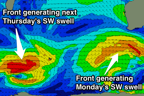
Sunday will unfortunately see a return to onshores (S/SE early around Perth and Gero) as a cold front pushing up from the south-west clips the state but this should bring with it a new SW groundswell for Monday discussed below.
Monday onwards (Dec 15 onwards)
As touched on above, a broad but relatively weak cold front pushing up from the Heard Island region into us on Sunday will bring with it a moderate to large sized SW groundswell for Monday.
The South West should see 6ft to occasionally 8ft sets across exposed breaks with 2ft+ waves into the afternoon around Perth and 3-5ft sets up at Gero into the late afternoon and more so Tuesday morning.
Winds are expected to still be onshore from the SW into Monday unfortunately but Tuesday on the backside of the swell looks cleaner but still not great under a S/SE'ly. Wednesday will be cleaner but smaller again with fresh SE winds.
Longer term another moderate sized + SW groundswell pulse is on the cards for Thursday but more on this Friday.