Good waves Tuesday ahead of large, stormy and onshore conditions Thursday onwards

Western Australia Surf Forecast by Craig Brokensha (issued Monday 5th of May)
Best Days: Tuesday, dawn Wednesday, Saturday
Recap
The weekend was best across exposed locations across the state, namely Gero and Margaret River with a moderate S'ly groundswell and offshore winds.
Today the swell has steadied in the small to moderate range as fresh offshores winds continued to create clean conditions before tending more N/NE this afternoon.
This week (May 5 - 9)
The surf should perk up a little tomorrow with the arrival of a long-range SW groundswell to 4-6ft in the South West during the afternoon, 1-2ft in Perth and 3-4ft up at Gero. Winds will continue to be favourable with E/NE offshores during the morning that should tend variable into the afternoon.
Wednesday will then be a day to miss with an easing swell and strengthening N/NW'ly as a vigorous mid-latitude front moves in from the west.
This front will see a fetch of W/SW gales pushing into the coast on Thursday kicking up a large and stormy W'ly swell for Thursday afternoon and Friday morning.
The models look to be over-forecasting the size a little with a stormy 10ft+ of swell due in the South West, 3-5ft in Perth and 6-8ft in Gero but with strong W/NW winds Thursday and W/SW tending SW winds on Friday.
This weekend onwards (May 10 onwards)
The swell from the mid-latitude front should continue to back off into Saturday but winds will remain onshore and from the West but without much strength across Margs. Further north we should see more variable winds, creating cleaner conditions.
Into Sunday though, a large and powerful SW groundswell is due, generated by a couple of vigorous polar fronts firing up around the Heard Island region.
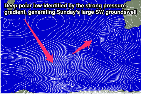 An initial broad fetch of severe-gales will setup an active sea state for a secondary polar low to piggyback over the top of (pictured right), generating an additional fetch of severe-gales and large W/SW groundswell.
This should produce a large SW groundswell that should arrive overnight Saturday and peak Sunday to 8-10ft in the South West, 3ft in Perth and 5-6ft up at Gero. Unfortunately another approaching front will bring with it increasing NW winds leaving no options for a decent wave.
Longer term the run of large swell and average winds will continue into next week with no let up likely until later in the week. Check back here on Wednesday though for clarification on this.